SUMMARY
This is AI generated summarization, which may have errors. For context, always refer to the full article.
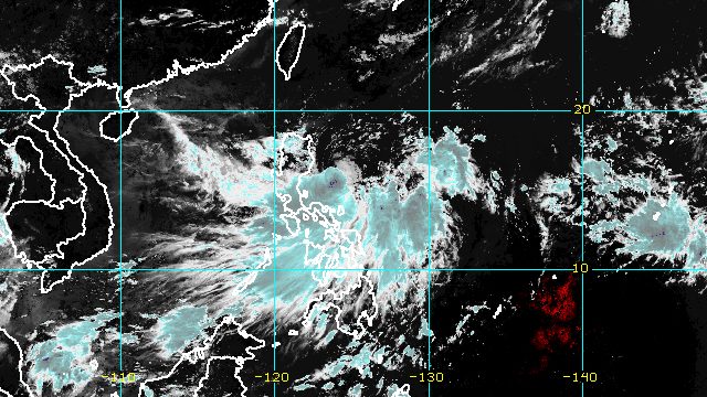
MANILA, Philippines – Florita intensified from a tropical depression into a tropical storm at 8 am on Monday, August 22, while still moving over the Philippine Sea.
In a briefing past 11 am on Monday, the Philippine Atmospheric, Geophysical, and Astronomical Services Administration (PAGASA) said Florita now has maximum sustained winds of 75 kilometers per hour from the previous 55 km/h. Its gustiness increased to 90 km/h from 70 km/h.
The tropical storm was already 215 kilometers east of Casiguran, Aurora, moving west southwest at a slightly slower 15 km/h from the previous 20 km/h.
With Florita now a tropical storm, Signal No. 2 has been raised for the first time. Here are the areas under tropical cyclone wind signals as of 11 am on Monday:
Signal No. 2 (gale-force winds, 62 to 88 km/h)
- eastern part of Cagayan (Enrile, Tuguegarao City, Peñablanca, Iguig, Baggao, Gattaran, Lal-lo, Gonzaga, Santa Teresita, Buguey, Santa Ana)
- eastern part of Isabela (Cabagan, San Pablo, Santa Maria, Maconacon, Divilacan, Palanan, San Mariano, Ilagan City, Delfin Albano, Tumauini, Santo Tomas, Quezon, Mallig, Roxas, Quirino, San Manuel, Aurora, Cabatuan, Luna, Burgos, Gamu, Reina Mercedes, Cauayan City, Alicia, San Isidro, Echague, Jones, San Agustin, San Guillermo, Angadanan, Naguilian, Benito Soliven, Dinapigue)
- extreme northern part of Aurora (Dilasag, Casiguran)
- northeastern part of Quirino (Maddela)
Signal No. 1 (strong winds, 39 to 61 km/h)
- rest of Cagayan
- rest of Isabela
- rest of Quirino
- Nueva Vizcaya
- Apayao
- Abra
- Kalinga
- Mountain Province
- Ifugao
- Benguet
- La Union
- Ilocos Norte
- Ilocos Sur
- northern part of Aurora (Dinalungan, Dipaculao, Baler, Maria Aurora, San Luis)
- northern part of Polillo Island (Panukulan, Burdeos)
PAGASA also updated its rainfall forecast for Florita.
Monday, August 22
Light to moderate rain, with at times heavy rain
- Cagayan
- Isabela
- Batanes
- Aurora
- Ilocos Norte
- Ilocos Sur
- La Union
Tuesday, August 23
Heavy to intense rain, with at times torrential rain
- Cagayan
- Isabela
- Batanes
- Cordillera Administrative Region
- Ilocos Region
Moderate to heavy rain
- rest of Cagayan Valley
- northern part of Aurora
- Zambales
- Bataan
Light to moderate rain, with at times heavy rain
- rest of Central Luzon
The weather bureau reminded the public to be on alert for floods and landslides.
Florita is seen to make landfall in the east coast of Cagayan or the northern part of Isabela on Tuesday afternoon, August 23. While it may slightly weaken after hitting land, it is expected to remain a tropical storm.
Florita is then likely to cross the Babuyan Channel and pass close to Babuyan Islands on Tuesday evening or early Wednesday morning, August 24, before emerging over the West Philippine Sea.
Florita is expected to leave the Philippine Area of Responsibility on Wednesday. Outside PAR, it could intensify into a severe tropical storm and reach a peak intensity of 95 km/h.

PAGASA also issued a separate advisory for the southwest monsoon or hanging habagat, which is being enhanced by Florita.
In its 11 am advisory on Monday, the weather bureau provided the following rainfall forecast for the enhanced southwest monsoon:
Moderate to heavy rain, with at times intense rain
- Mimaropa
- Bicol
- Quezon
- Western Visayas
- Eastern Samar
- Northern Samar
- Samar
Light to moderate rain, with at times heavy rain
- Metro Manila
- rest of Calabarzon
- rest of Visayas
Scattered floods and landslides are possible.
Gusts are also expected due to the southwest monsoon in these areas:
- Bicol
- Batangas
- Occidental Mindoro
- Oriental Mindoro
- Marinduque
- Romblon
- Northern Samar
- Antique
- Aklan
The bad weather came as thousands of schools in the Philippines reopened for face-to-face classes on Monday. – Rappler.com
Add a comment
How does this make you feel?


There are no comments yet. Add your comment to start the conversation.