SUMMARY
This is AI generated summarization, which may have errors. For context, always refer to the full article.
MANILA, Philippines – Tropical Storm Florita, which was given the international name Ma-on, could make landfall hours earlier than initially expected on Tuesday, August 23.
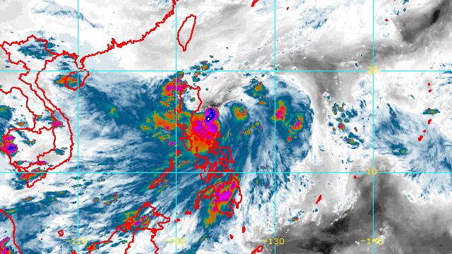
Florita was located 155 kilometers east of Casiguran, Aurora, on Monday afternoon, August 22, moving west at 15 kilometers per hour (km/h).
The Philippine Atmospheric, Geophysical, and Astronomical Services Administration (PAGASA) said in a bulletin released past 5 pm on Monday that Florita could make landfall in Isabela or Cagayan early Tuesday morning, instead of Tuesday afternoon.
As of Monday afternoon, Florita maintained its strength, with maximum sustained winds of 75 km/h and gustiness of up to 90 km/h.
But PAGASA said Florita may strengthen into a severe tropical storm before hitting land.
Florita is bringing rain not just to the Northern Luzon provinces directly in its path. Its trough or extension is affecting several other areas as well.
The tropical storm is also enhancing the southwest monsoon or hanging habagat, which is another source of rain for Southern Luzon and Western Visayas.
This is PAGASA’s rainfall forecast as of 5 pm on Monday:
Monday, August 22
Moderate to heavy rain, with at times intense rain
- Camarines Norte
- Camarines Sur
- Quezon including Polillo Islands
Moderate to heavy rain
- Ilocos Region
- Apayao
- Cagayan
Light to moderate rain, with at times heavy rain
- Central Luzon
- Batanes
- Isabela
- Occidental Mindoro
- Oriental Mindoro
- Romblon
- Marinduque
- Metro Manila
- rest of Calabarzon
- rest of Bicol
Tuesday, August 23
Heavy to intense rain, with at times torrential rain
- Cagayan
- Isabela
- Batanes
- Cordillera Administrative Region
- Ilocos Region
Moderate to heavy rain, with at times intense rain
- Aurora
- Zambales
- Bataan
Light to moderate rain, with at times heavy rain
- rest of Cagayan Valley
- rest of Central Luzon
Both Florita and the southwest monsoon are expected to trigger floods and landslides.
The list of areas under tropical cyclone wind signals was also expanded at 5 pm on Monday.
Signal No. 2
Gale-force winds (62 to 88 km/h), minor to moderate threat to life and property
- Cagayan
- Isabela
- Quirino
- eastern part of Nueva Vizcaya (Alfonso Castañeda, Dupax del Norte, Kasibu, Quezon, Bambang, Ambaguio, Bayombong, Solano, Villaverde, Bagabag, Diadi)
- Apayao
- eastern part of Abra (Tubo, Boliney, Bucloc, Daguioman, Sallapadan, Licuan-Baay, Malibcong, Lacub, Tineg, Lagangilang, Bucay, Manabo, Luba)
- Kalinga
- Mountain Province
- Ifugao
- northern and central parts of Aurora (Dilasag, Casiguran, Dinalungan, Dipaculao, Baler, Maria Aurora)
Signal No. 1
Strong winds (39 to 61 km/h), minimal to minor threat to life and property
- Babuyan Islands
- rest of Nueva Vizcaya
- rest of Abra
- Benguet
- Ilocos Norte
- Ilocos Sur
- La Union
- eastern part of Pangasinan (Urbiztondo, Bayambang, Bautista, Alcala, Santo Tomas, Rosales, Balungao, Umingan, San Quintin, Natividad, Tayug, San Nicolas, San Manuel, Asingan, San Carlos City, Lingayen, Binmaley, Basista, Malasiqui, Villasis, Santa Maria, Urdaneta City, Binalonan, Laoac, Manaoag, Pozorrubio, Sison, San Fabian, San Jacinto, Mapandan, Santa Barbara, Mangaldan, Dagupan City, Calasiao)
- eastern part of Tarlac (San Manuel, Moncada, Anao, Paniqui, Ramos, Gerona, Pura, Victoria, Tarlac City, Concepcion, La Paz)
- Nueva Ecija
- rest of Aurora
- eastern part of Pampanga (Magalang, Arayat, Candaba)
- eastern part of Bulacan (San Miguel, Doña Remedios Trinidad, San Ildefonso, San Rafael, Angat, Norzagaray, San Jose del Monte City)
- northeastern part of Rizal (Rodriguez, San Mateo, Antipolo City, Tanay, Baras)
- northern part of Quezon (Infanta, General Nakar, Real) including Polillo Islands
- northern part of Laguna (Santa Maria, Famy, Siniloan, Pangil, Pakil, Paete)
- Camarines Norte
The highest possible tropical cyclone wind signal to be raised due to Florita is Signal No. 3.
Gusts are also expected due to the southwest monsoon in these areas:
- Bicol
- Batangas
- Occidental Mindoro
- Oriental Mindoro
- Marinduque
- Romblon
- Northern Samar
- Antique
- Aklan
Meanwhile, PAGASA issued a gale warning for the following seaboards due to the effects of Florita and the southwest monsoon:
- eastern seaboards of Northern Luzon, Central Luzon, and Southern Luzon – rough to very rough seas, with waves 2.8 to 5 meters high
- western and southern seaboards of Southern Luzon, northern seaboard of Northern Luzon, western seaboard of Visayas – rough seas, with waves 2.8 to 4 meters high
Fishing boats and other small vessels should not sail.
Florita is also affecting coastal conditions in other seaboards, making travel risky for small vessels:
- western seaboards of Northern Luzon and Central Luzon, eastern seaboards of Visayas and Mindanao – moderate to rough seas, with waves 1.2 to 2.8 meters high
After Florita’s projected landfall as a severe tropical storm early Tuesday morning, it is expected to cross several provinces in Northern Luzon. Then it may emerge over the West Philippine Sea on Tuesday evening or early Wednesday morning, August 24.
The latest forecast track also shows Florita possibly weakening back into a tropical storm while crossing Northern Luzon.
But after its exit from the Philippine Area of Responsibility on Wednesday, it could re-intensify into a severe tropical storm and reach a peak intensity of 95 km/h.
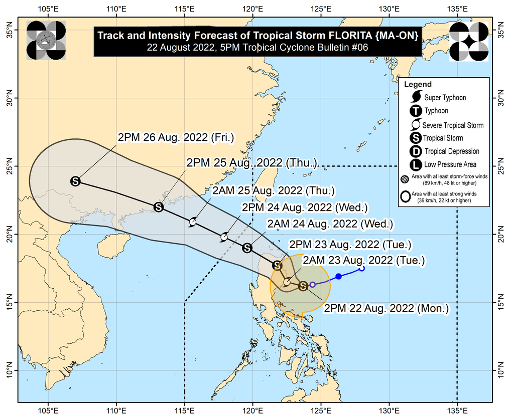
Florita is the Philippines’ sixth tropical cyclone for 2022. – Rappler.com
Add a comment
How does this make you feel?


There are no comments yet. Add your comment to start the conversation.