SUMMARY
This is AI generated summarization, which may have errors. For context, always refer to the full article.
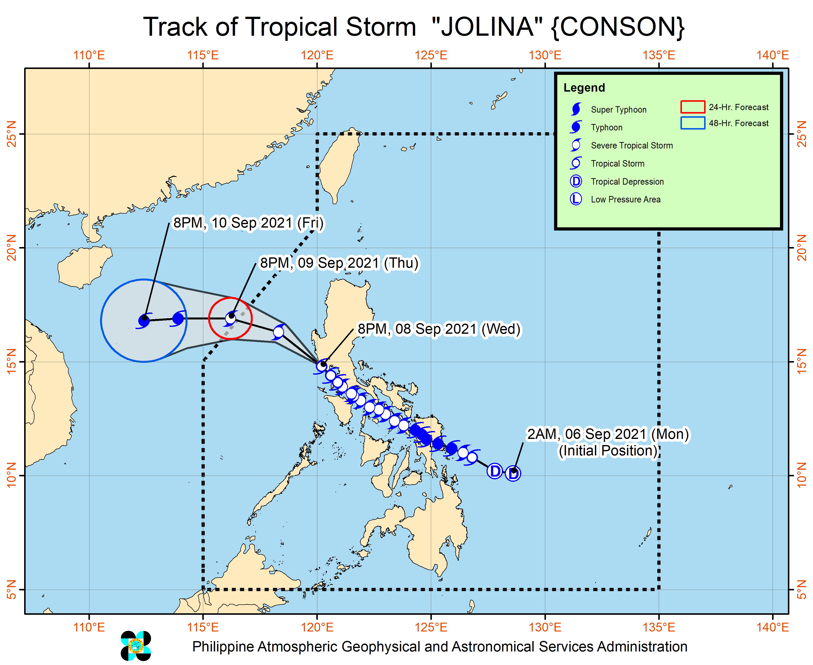
After making landfall nine times in the Philippines, Tropical Storm Jolina (Conson) left land for the final time through the province of Zambales on Wednesday evening, September 8.
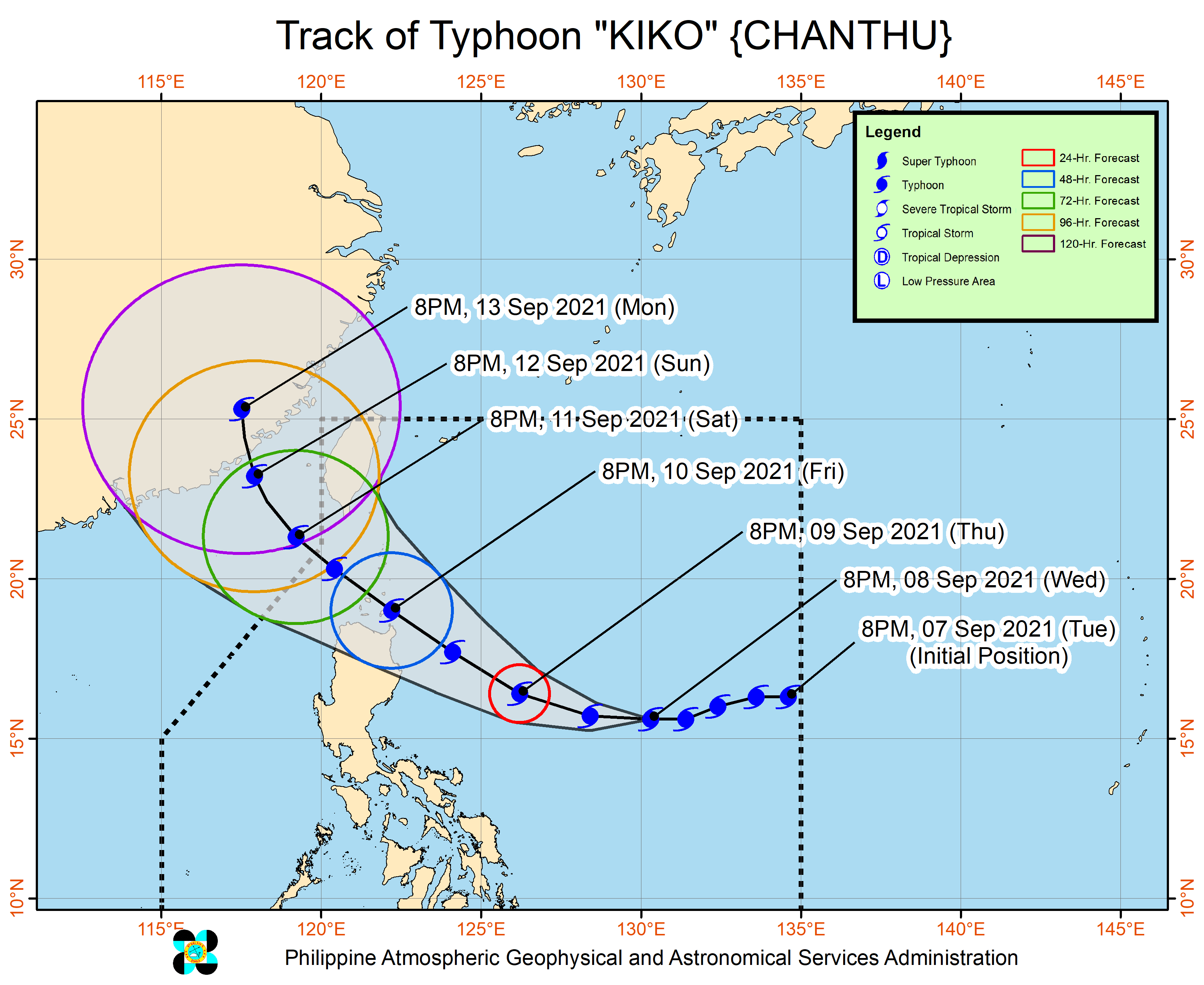
Typhoon Kiko (Chanthu), meanwhile, maintained its strength over the Philippine Sea.
Jolina
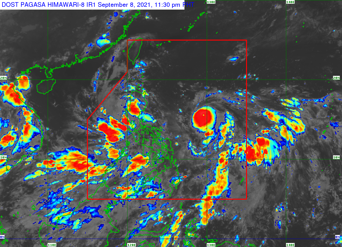
In a briefing past 11 pm, the Philippine Atmospheric, Geophysical, and Astronomical Services Administration (PAGASA) said Jolina was already over the coastal waters of Cabangan, Zambales.
The tropical storm again accelerated, now moving northwest at 20 kilometers per hour from the previous 15 km/h.
It continues to have maximum sustained winds of 85 km/h and gustiness of up to 115 km/h.
Fewer areas will see rain from Jolina now that it is starting to move away from land. Note, however, that the rain will still be mostly moderate to heavy, and possibly intense at times. Scattered floods and rain-induced landslides can still hit the affected areas:
- Zambales
- Bataan
- Tarlac
- Pampanga
- Nueva Ecija
- Bulacan
- Aurora
- Pangasinan
- Cavite
- Batangas
There are also fewer areas under tropical cyclone wind signals as of 11 pm on Wednesday.
Signal No. 2 (damaging gale-force winds)
- western part of Tarlac (Bamban, Capas, San Jose, Mayantoc)
- western part of Pampanga (Mabalacat City, Angeles City, Porac, Floridablanca, Lubao, Guagua, Santa Rita, Bacolor, San Fernando City, Minalin, Sasmuan, Macabebe, Masantol, Santo Tomas)
- Zambales
- northern part of Bataan (Samal, Bagac, Pilar, Morong, Dinalupihan, Abucay, Balanga City, Orion, Orani, Hermosa)
Signal No. 1 (strong winds with occasional gusts)
- Pangasinan
- rest of Tarlac
- Nueva Ecija
- southern part of Aurora (Dingalan)
- rest of Pampanga
- rest of Bataan
- Bulacan
- Metro Manila
- Rizal
- northern part of Quezon (General Nakar)
- Cavite
- western part of Laguna (Santa Maria, Los Baños, Bay, Calamba City, Cabuyao City, Santa Rosa City, Biñan City, San Pedro City)
- western part of Batangas (Santo Tomas, Malvar, Balete, Mataasnakahoy, Cuenca, Lipa City, San Jose, Mabini, San Pascual, Alitagtag, Bauan, Santa Teresita, San Luis, Taal, San Nicolas, Tanauan City, Talisay, Laurel, Agoncillo, Lemery, Balayan, Calaca, Tuy, Nasugbu, Lian, Calatagan)
- Lubang Islands
But PAGASA warned of possible “coastal inundation resulting from hazardous surf conditions” in several coastal areas of Zambales and Bataan.
Some sea trips remain risky as well.
Rough to very rough seas (waves 2.5 to 4.5 meters high)
Travel risky for all vessels, inexperienced mariners should seek safe harbor
- seaboards of areas under Signal No. 2
Moderate to rough seas (waves 1.2 to 2.8 meters high)
Small vessels must take precautionary measures, inexperienced mariners should avoid navigation
- seaboards of areas under Signal No. 1
- western seaboards of Northern Luzon and Southern Luzon
These were Jolina’s nine landfalls in the Philippines:
Monday, September 6 (as a typhoon)
- Hernani, Eastern Samar – 10 pm
Tuesday, September 7 (as a typhoon)
- Daram, Samar – 2 am
- Santo Niño, Samar – 3:40 am
- Almagro, Samar – 6:30 am
- Tagapul-an, Samar – 7:50 am
- Dimasalang, Masbate – 10 am
Wednesday, September 8 (as a severe tropical storm)
- Torrijos, Marinduque – 12:50 am
- San Juan, Batangas – 9 am
Wednesday, September 8 (as a tropical storm)
- Mariveles, Bataan – 5:30 pm
Jolina will keep moving northwest over the West Philippine Sea until Thursday, September 9.
It will finally exit the Philippine Area of Responsibility (PAR) on Thursday evening.
Jolina is also expected to re-intensify into a severe tropical storm on Thursday, and into a typhoon on Friday, September 10. (READ: FAST FACTS: Tropical cyclones, rainfall advisories)
Kiko
Meanwhile, Kiko was located 895 kilometers east of Central Luzon late Wednesday evening, moving west at 20 km/h.
The typhoon still has maximum sustained winds of 175 km/h and gustiness of up to 215 km/h.
But it is expected to resume intensifying within the next 12 hours, and reach a peak intensity between 185 km/h and 205 km/h by Friday evening while crossing the Babuyan archipelago.
PAGASA said heavy rain from Kiko could begin affecting Northern Luzon on Friday.
Tropical cyclone wind signals will also be raised for several provinces in Northern Luzon early Thursday morning. Signal No. 4 would be the highest possible tropical cyclone wind signal due to Kiko.
PAGASA added that Kiko will already trigger moderate to rough seas, with waves 1.2 to 3 meters high, in these areas on Thursday:
- northern and eastern seaboards of Northern Luzon
- eastern seaboard of Central Luzon
Small vessels must take precautionary measures.
“Due to the strength of this tropical cyclone, sea condition over the aforementioned waters will further worsen by Friday, making sea travel risky for all types of seacraft,” the state weather bureau warned.
PAGASA expects Kiko to keep moving west in the next 12 hours, before turning west northwest until Friday morning and northwest for the rest of Friday until Saturday, September 11.
The typhoon is seen to pass very close to the northeastern part of Cagayan and cross the vicinity of Babuyan Islands between Friday afternoon and early Saturday morning.
PAGASA is also not ruling out the possibility of Kiko making landfall in mainland Cagayan, since its track has been shifting southward.
After crossing Babuyan Islands and the Luzon Strait, the typhoon might leave PAR on Saturday afternoon or evening.
Weakening may begin by Sunday, September 12, as the typhoon approaches the coastal waters of southeastern mainland China.
On Sunday evening or Monday morning, September 13, Kiko might make landfall in the southeastern part of China.
Jolina and Kiko are the Philippines’ 10th and 11th tropical cyclones for 2021.
An average of 20 tropical cyclones form within or enter PAR each year. (READ: LIST: PAGASA’s names for tropical cyclones in 2021)
For the next six months, these are PAGASA’s estimates for the number of tropical cyclones inside PAR:
2021
- September – 2 or 3
- October – 2 or 3
- November – 2 or 3
- December – 1 or 2
2022
- January – 0 or 1
- February – 0 or 1
– Rappler.com
Add a comment
How does this make you feel?


There are no comments yet. Add your comment to start the conversation.