SUMMARY
This is AI generated summarization, which may have errors. For context, always refer to the full article.
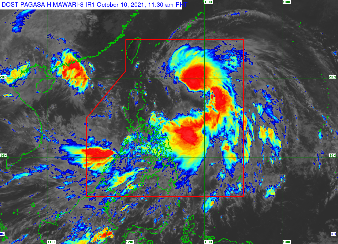
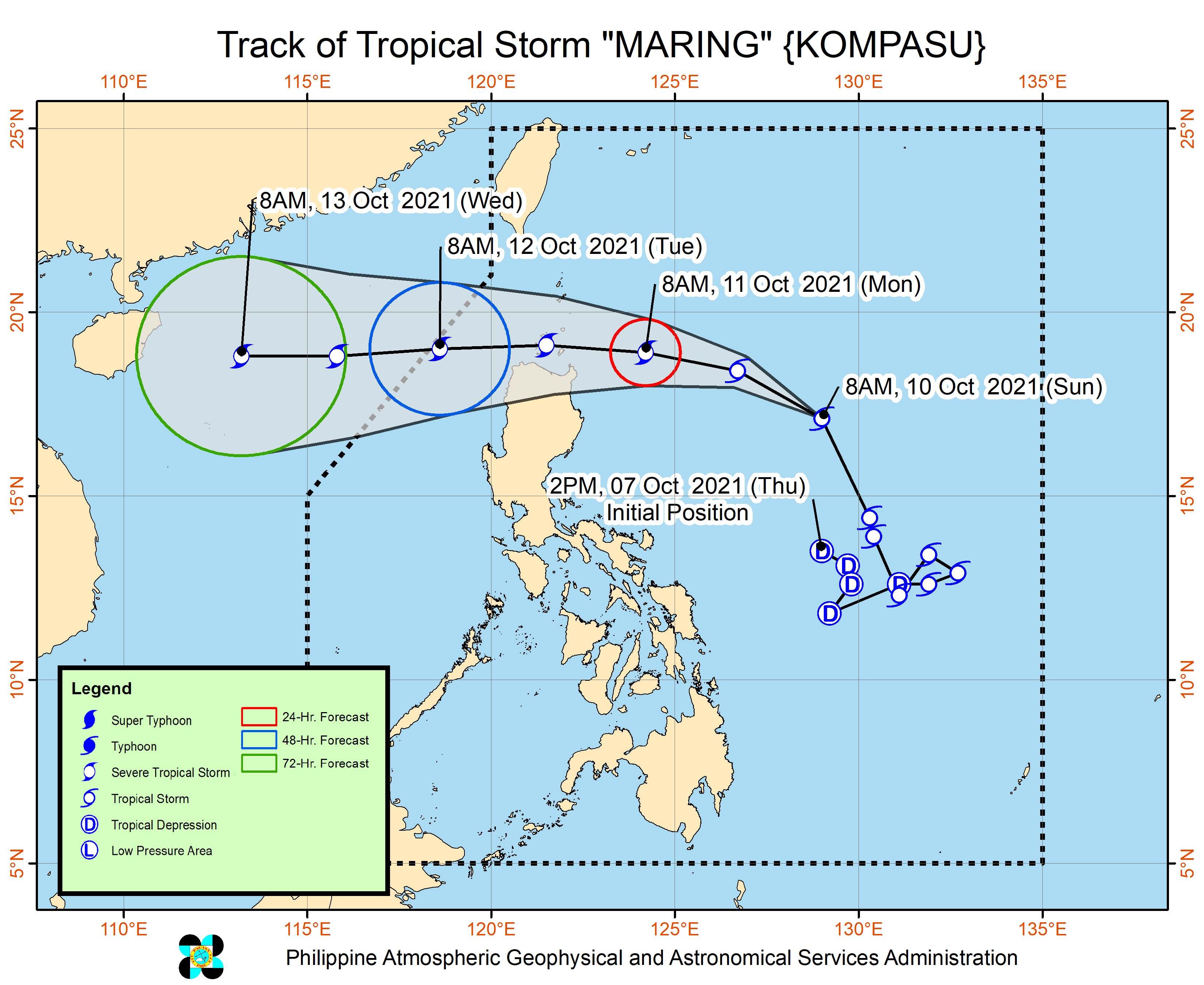
Tropical Storm Maring (Kompasu) finished merging with the remnants of Tropical Depression Nando late Sunday morning, October 10, and shifted north northwest over the Philippine Sea.
The Philippine Atmospheric, Geophysical, and Astronomical Services Administration (PAGASA) said Maring was already 730 kilometers east of Tuguegarao City, Cagayan.
The tropical storm accelerated, moving at 30 kilometers per hour from the previous 10 km/h.
It maintained its strength, with maximum sustained winds of 85 km/h and gustiness of up to 105 km/h.
But PAGASA said Maring may intensify into a severe tropical storm within 24 hours. (READ: FAST FACTS: Tropical cyclones, rainfall advisories)
The list of areas under Signal No. 1 was further expanded as of 11 am on Sunday. Strong winds are expected in these provinces:
- Batanes
- Cagayan including Babuyan Islands
- Isabela
- Apayao
- Abra
- Kalinga
- Mountain Province
- Ifugao
- northern part of Benguet (Buguias, Bakun, Kibungan, Mankayan)
- Ilocos Norte
- Ilocos Sur
- Catanduanes
- Eastern Samar
- eastern part of Northern Samar (San Roque, Pambujan, Las Navas, Catubig, Laoang, Mapanas, Lapinig, Gamay, Palapag, Mondragon, Silvino Lobos)
- eastern part of Samar (Matuguinao, San Jose de Buan, Hinabangan, Paranas)
- Dinagat Islands
- Surigao del Norte
Occasional gusts remain possible in coastal and mountainous areas of the regions below, even if they are not under a tropical cyclone wind signal. This is due to Maring’s “expansive wind field” and “the gradual enhancement of the southwesterlies and northeasterlies,” said PAGASA.
- Mimaropa
- Bicol
- Visayas
- Caraga
- Northern Mindanao
The enhanced southwesterlies will also bring rain to these areas on Sunday:
- Western Visayas
- Zamboanga Peninsula
- Palawan
- Occidental Mindoro
Maring, meanwhile, is causing rain in Bicol and much of the Visayas on Sunday. Isolated to scattered floods and landslides could occur.
Moderate to heavy rain
- Catanduanes
Light to moderate rain, with at times heavy rain
- rest of Bicol
- rest of Visayas
A gale warning is still in effect for the eastern seaboards of the Philippines due to Maring and the northeasterly wind flow. Waters are rough to very rough, with waves 2.8 to 4.5 meters high.
PAGASA advised fishing boats and other small vessels not to sail, while larger vessels must watch out for big waves.
In the remaining seaboards of Luzon and the Visayas and in the northern seaboard of Mindanao, waters remain moderate to rough. Travel is risky for small vessels.
Maring is projected to move west northwest toward extreme Northern Luzon, then west over the Luzon Strait. It might pass close to or over the Babuyan Islands between Monday evening, October 11, and Tuesday morning, October 12.
Landfall in mainland Luzon, however, remains a possibility.
Finally, Maring could move over the West Philippine Sea beginning Tuesday and leave the Philippine Area of Responsibility (PAR) on Tuesday morning.
Maring is the Philippines’ 13th tropical cyclone for 2021 and the second for October, while Nando was the country’s 14th for the year and the third for the month.
Before being absorbed by Maring, Nando had weakened into a low pressure area or a remnant low on Saturday evening, October 9. Nando also did not affect weather in the country as it stayed far from land, over the Philippine Sea.
An average of 20 tropical cyclones form within or enter PAR each year. (READ: LIST: PAGASA’s names for tropical cyclones in 2021)
These are PAGASA’s latest estimates for the next six months:
2021
- October – 2 or 3
- November – 2 or 3
- December – 1 or 2
2022
- January – 0 or 1
- February – 0 or 1
- March – 0 or 1
The weather bureau is also monitoring the possible emergence of La Niña in the fourth quarter of 2021. – Rappler.com
Add a comment
How does this make you feel?


There are no comments yet. Add your comment to start the conversation.