SUMMARY
This is AI generated summarization, which may have errors. For context, always refer to the full article.
The weather bureau warned on Sunday afternoon, October 10, that rain could become intense due to Tropical Storm Maring (Kompasu).
Signal No. 2, referring to damaging winds, was also raised for the first time at 5 pm on Sunday.
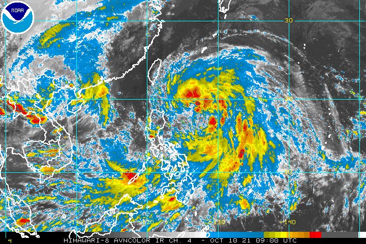
The Philippine Atmospheric, Geophysical, and Astronomical Services Administration (PAGASA) said Maring was last spotted 645 kilometers east of Tuguegarao City, Cagayan, or 655 kilometers east of Aparri, Cagayan, still over the Philippine Sea.
The tropical storm shifted west northwest and slowed down, moving at 20 kilometers per hour from the previous 30 km/h.
It continues to have maximum sustained winds of 85 km/h and gustiness of up to 105 km/h.
But Maring could intensify into a severe tropical storm within 12 hours, or by early Monday morning, October 11. (READ: FAST FACTS: Tropical cyclones, rainfall advisories)
PAGASA updated its rainfall forecast for Maring, covering Sunday evening to Monday evening:
Moderate to heavy rain, with at times intense rain
- Batanes
- Cagayan including Babuyan Islands
- Cordillera Administrative Region
- Ilocos Region
Light to moderate rain, with at times heavy rain
- rest of Cagayan Valley
- Central Luzon
The southwesterlies enhanced by Maring may also bring rain to these areas:
- Visayas
- Zamboanga Peninsula
- Palawan
- Occidental Mindoro
PAGASA warned areas affected by the tropical storm and the enhanced southwesterlies to watch out for scattered to widespread floods and landslides.
The rest of the country, including Metro Manila, will only have localized thunderstorms.
Meanwhile, here are the areas under tropical cyclone wind signals as of 5 pm on Sunday:
Signal No. 2 (damaging gale-force to storm-force winds)
- Batanes
- Cagayan including Babuyan Islands
- northern part of Isabela (Santa Maria, Quezon, Cabagan, Delfin Albano, Santo Tomas, Tumauini, Maconacon, San Pablo, Divilacan, Palanan, Ilagan City)
- Apayao
- northern part of Kalinga (Balbalan, Pinukpuk, Rizal, Tabuk City)
- northeastern part of Ilocos Norte (Pagudpud, Adams, Dumalneg, Bangui, Vintar, Carasi)
Signal No. 1 (strong winds)
- rest of Ilocos Norte
- Ilocos Sur
- La Union
- Pangasinan
- Abra
- rest of Kalinga
- Mountain Province
- Ifugao
- Benguet
- rest of Isabela
- Quirino
- Nueva Vizcaya
- northern and central parts of Aurora (Dilasag, Dinalungan, Casiguran, Dipaculao, Maria Aurora, Baler)
- northern part of Nueva Ecija (Carranglan, Lupao, Pantabangan, San Jose City)
- Catanduanes
- Eastern Samar
- eastern part of Northern Samar (San Roque, Pambujan, Las Navas, Catubig, Laoang, Mapanas, Lapinig, Gamay, Palapag, Mondragon, Silvino Lobos)
- eastern part of Samar (Matuguinao, San Jose de Buan, Hinabangan, Paranas)
There are no more areas in Mindanao under a tropical cyclone wind signal.
Occasional gusts also remain possible in coastal and mountainous areas of the regions below. This is due to Maring’s “expansive wind field” and “the enhancement of the southwesterlies and northeasterlies,” said PAGASA.
- Mimaropa
- Bicol
- Visayas
- Caraga
- Northern Mindanao
A gale warning was issued at 5 pm on Sunday for the eastern seaboards of Central Luzon and Southern Luzon as well as the northern coast of Northern Samar. Maring is causing rough to very rough waters, with waves 2.8 to 4.5 meters high.
PAGASA advised fishing boats and other small vessels not to sail, while larger vessels must watch out for big waves.
In the remaining seaboards of Luzon and the Visayas and in the northern and eastern seaboards of Mindanao, waters remain moderate to rough. Travel is risky for small vessels.
Maring is seen to maintain its west northwest direction until the early hours of Monday, before it turns west toward extreme Northern Luzon.
It could then move over the Luzon Strait and pass close to or over the Babuyan Islands between Monday afternoon and early Tuesday morning, October 12.
But the weather bureau reiterated it is not yet ruling out the possibility of Maring making landfall in mainland Luzon.
Maring is likely to leave the Philippine Area of Responsibility (PAR) on Tuesday morning or afternoon.
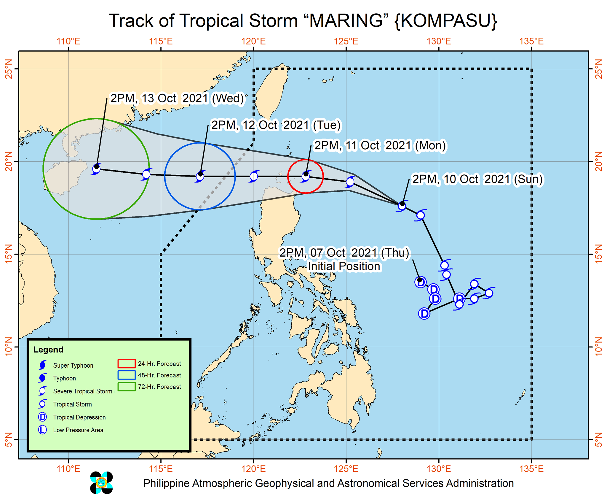
Maring is the Philippines’ 13th tropical cyclone for 2021 and the second for October.
On Sunday morning, Maring had completed its merger with the remnant low that was formerly Tropical Depression Nando. The two tropical cyclones had interacted over the Philippine Sea, resulting in the merger.
Nando, the Philippines’ 14th tropical cyclone for 2021, had no impact on weather in the country.
An average of 20 tropical cyclones form within or enter PAR each year. (READ: LIST: PAGASA’s names for tropical cyclones in 2021)
These are PAGASA’s latest estimates for the next six months:
2021
- October – 2 or 3
- November – 2 or 3
- December – 1 or 2
2022
- January – 0 or 1
- February – 0 or 1
- March – 0 or 1
The weather bureau is also monitoring the possible emergence of La Niña in the fourth quarter of 2021. – Rappler.com
Add a comment
How does this make you feel?


There are no comments yet. Add your comment to start the conversation.