SUMMARY
This is AI generated summarization, which may have errors. For context, always refer to the full article.
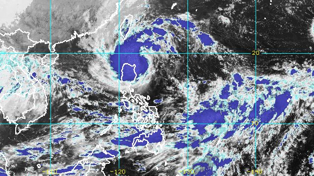
MANILA, Philippines – Tropical Storm Neneng (Nesat) intensified further as it continued moving toward the Babuyan Islands-Batanes area early Saturday evening, October 15.
Neneng now has maximum sustained winds of 75 kilometers per hour from the previous 65 km/h, the Philippine Atmospheric, Geophysical, and Astronomical Services Administration (PAGASA) said in its 8 pm bulletin on Saturday. The tropical storm’s gustiness is now up to 90 km/h from 80 km/h.
Neneng is now seen to strengthen into a severe tropical storm either Saturday evening or early Sunday morning, October 16, while in the Babuyan Islands-Batanes area. It may eventually become a typhoon on Monday, October 17, or Tuesday, October 18.
PAGASA also said Neneng may pass very close to or make landfall in Babuyan Islands or Batanes late Saturday evening or early Sunday morning, earlier than previously thought.
As of early Saturday evening, the tropical storm was already 225 kilometers east southeast of Calayan, Cagayan, or 200 kilometers east of Aparri, Cagayan.
Neneng is still moving west, but its speed halved to 15 km/h.
PAGASA reiterated that rain from the tropical storm may cause floods and landslides in Northern Luzon. It maintained this rainfall forecast:
Until Saturday evening, October 15
Heavy to intense rain, with at times torrential rain
- Batanes
- Cagayan including Babuyan Islands
Moderate to heavy rain, with at times intense rain
- Apayao
- Kalinga
- Abra
- Ilocos Norte
Light to moderate rain, with at times heavy rain
- northern part of Isabela
- rest of Cordillera Administrative Region
- rest of Ilocos Region
Sunday, October 16
Heavy to intense rain, with at times torrential rain
- Batanes
- northern part of mainland Cagayan
- Babuyan Islands
- Ilocos Norte
Moderate to heavy rain, with at times intense rain
- Apayao
- Kalinga
- Abra
- Ilocos Sur
- rest of mainland Cagayan
Light to moderate rain, with at times heavy rain
- northern part of Isabela
- rest of Cordillera Administrative Region
- rest of Ilocos Region
The weather bureau also said the trough or extension of the tropical storm “and the convergence of its circulation with the southwesterly winds” could bring occasional rain to the western parts of Mimaropa and Western Visayas. A separate weather advisory may be issued.
In terms of winds, Signal Nos. 1 and 2 are still raised, with more areas added under Signal No. 1 as of 8 pm on Saturday:
Signal No. 2
Gale-force winds (62 to 88 km/h), minor to moderate threat to life and property
- Batanes
- Cagayan including Babuyan Islands
- Apayao
- northern part of Abra (Tineg, Lacub, Lagayan)
- Ilocos Norte
Signal No. 1
Strong winds (39 to 61 km/h), minimal to minor threat to life and property
- northern and central parts of Isabela (Santa Maria, San Pablo, Maconacon, Divilacan, Palanan, Ilagan City, Tumauini, Cabagan, Santo Tomas, Quezon, Delfin Albano, Mallig, Quirino, Gamu, Roxas, San Mariano, Benito Soliven, Naguilian, Burgos, Reina Mercedes, San Manuel, Aurora, Luna, Cabatuan, San Mateo, Dinapigue, Cauayan City)
- Kalinga
- rest of Abra
- Mountain Province
- northern part of Ifugao (Aguinaldo, Alfonso Lista, Mayoyao, Hungduan, Banaue)
- northern and central parts of Ilocos Sur (Sinait, Cabugao, San Juan, Magsingal, Santo Domingo, San Ildefonso, San Vicente, Santa Catalina, Bantay, Vigan City, Santa, Caoayan, Narvacan, Nagbukel, Santa Maria, San Esteban, Santiago, Burgos, Banayoyo, Lidlidda, San Emilio, Quirino, Gregorio del Pilar, Galimuyod, Candon City, Santa Lucia, Salcedo, Cervantes, Suyo, Sigay, Santa Cruz)
PAGASA said Signal No. 3 is most likely the highest possible wind signal since Neneng is projected to become a severe tropical storm. But the weather bureau is not ruling out the possibility of raising Signal No. 4 if Neneng intensifies into a typhoon earlier than currently estimated.
The weather bureau added that there may be occasional gusts in Southern Luzon and the Visayas due to the convergence between Neneng’s circulation and the southwesterly winds.
As for coastal conditions, the gale warning issued at 5 pm on Saturday remains in effect. Seas are rough to very rough in these seaboards due to Neneng and the northeasterly surface windflow:
- seaboards of Northern Luzon (Batanes, Cagayan, Ilocos Norte) – waves 3.4 to 5 meters high
- eastern seaboard of Northern Luzon (Isabela) – waves 3.1 to 4.5 meters high
- western seaboard of Northern Luzon (Ilocos Sur, La Union) – waves 2.8 to 4.5 meters high
PAGASA advised fishing boats and other small vessels not to sail, and larger vessels to watch out for big waves.
The weather bureau added that the surge of the northeasterly surface windflow and Neneng may cause moderate to rough seas in the eastern seaboards of Central Luzon and Southern Luzon. Waves could be 2 to 3.5 meters high, making conditions risky for small vessels.
Neneng may exit the Philippine Area of Responsibility (PAR) on Monday as it shifts southwest “in response to an arriving northeasterly surge,” PAGASA said.

Neneng is the Philippines’ 14th tropical cyclone for 2022 and the second for October.
PAGASA expects 5 to 9 tropical cyclones to enter or develop inside PAR from October 2022 to March 2023. Per month, these are the weather bureau’s estimates:
- October 2022 – 2 to 4
- November 2022 – 2 or 3
- December 2022 – 1 or 2
- January 2023 – 0 or 1
- February 2023 – 0 or 1
- March 2023 – 0 or 1
– Rappler.com
Add a comment
How does this make you feel?


There are no comments yet. Add your comment to start the conversation.