SUMMARY
This is AI generated summarization, which may have errors. For context, always refer to the full article.
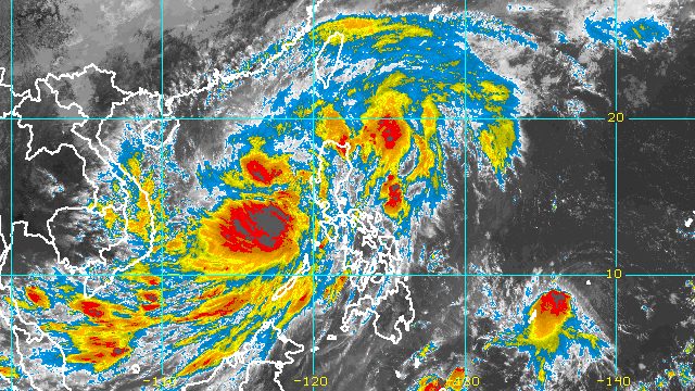
MANILA, Philippines – Some areas are still seeing rain and strong winds from Tropical Storm Paeng (Nalgae) on Sunday, October 30, even as the tropical cyclone continues to move away from land.
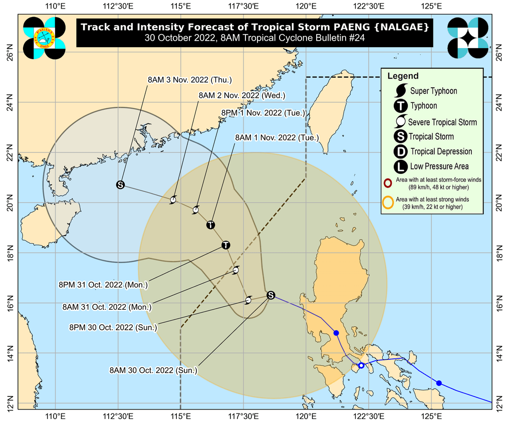
By late Sunday morning, Paeng was already 225 kilometers west northwest of Iba, Zambales, or 240 kilometers west of Dagupan City, Pangasinan.
The Philippine Atmospheric, Geophysical, and Astronomical Services Administration (PAGASA) said in a noontime briefing on Sunday that the tropical storm is moving west northwest at 25 kilometers per hour, slightly slower than the previous 30 km/h.
It remains on track to leave the Philippine Area of Responsibility (PAR) on Monday morning or afternoon, October 31.
Paeng continued to have maximum sustained winds of 85 km/h and gustiness of up to 105 km/h on Sunday morning. But over the West Philippine Sea, it could re-intensify into a severe tropical storm within 24 hours.
Paeng may also become a typhoon by Monday evening or on Tuesday morning, November 1, while outside PAR, but it may start weakening again late Tuesday due to another surge of the northeast monsoon or hanging amihan.
The following areas may still have rain from Paeng on Sunday:
Moderate to heavy rain
- Zambales
- Bataan
- Aurora
- Pangasinan
- Batanes
- northern part of Cagayan including Babuyan Islands
Light to moderate rain, with at times heavy rain
- Metro Manila
- Cordillera Administrative Region
- Calabarzon
- Mimaropa
- rest of Cagayan Valley
- rest of Central Luzon
- Camarines Norte
- Camarines Sur
- Western Visayas
PAGASA said floods and landslides “are likely to slowly subside,” except in areas which saw significant rainfall the past days or those still hit by persistent heavy rain.
Tropical cyclone wind signals have yet to be lifted, too. Here are the areas remaining under Signal Nos. 1 and 2 as of 11 am on Sunday:
Signal No. 2
Gale-force winds (62 to 88 km/h), minor to moderate threat to life and property
- La Union
- central and western parts of Pangasinan (San Fabian, San Jacinto, Mapandan, Santa Barbara, Malasiqui, Bautista, Alcala, Urbiztondo, Mangatarem, Basista, San Carlos City, Calasiao, Mangaldan, Dagupan City, Binmaley, Aguilar, Bugallon, Lingayen, Labrador, Infanta, Dasol, Mabini, Sual, Alaminos City, Burgos, Agno, Bani, Bolinao, Anda, Bayambang)
- northwestern part of Tarlac (Camiling, San Clemente, Santa Ignacia, Mayantoc, San Jose, Moncada)
- northern part of Zambales (Santa Cruz, Candelaria, Masinloc, Palauig, Iba)
Signal No. 1
Strong winds (39 to 61 km/h), minimal to minor threat to life and property
- Cagayan including Babuyan Islands
- Isabela
- Nueva Vizcaya
- Quirino
- Apayao
- Ifugao
- Mountain Province
- Kalinga
- Abra
- Benguet
- Aurora
- Bulacan
- Nueva Ecija
- Pampanga
- rest of Tarlac
- rest of Zambales
- Bataan
- Ilocos Norte
- Ilocos Sur
- rest of Pangasinan
- Metro Manila
- Batangas
- Cavite
- Laguna
- Rizal
- northern and central parts of Quezon (Lucena City, Pagbilao, Infanta, Tiaong, Unisan, Plaridel, San Antonio, Alabat, Candelaria, Lucban, Sampaloc, Padre Burgos, Sariaya, Tayabas City, Mauban, Dolores, General Nakar, Perez, Agdangan, Atimonan, Real) including Polillo Islands
- northern and central parts of Occidental Mindoro (Abra de Ilog, Mamburao, Santa Cruz, Paluan, Sablayan) including Lubang Islands
- northern and central parts of Oriental Mindoro (Naujan, Puerto Galera, Victoria, San Teodoro, Baco, Calapan City, Pola, Socorro, Pinamalayan, Gloria, Bansud)
The gale warning that PAGASA issued at 5 am on Sunday is still in place.
- western seaboards of Northern Luzon and Central Luzon (western coast of Ilocos Norte, Ilocos Sur, La Union, Pangasinan, Zambales, Bataan) – very rough to high seas, waves 4.5 to 7 meters high
- remaining seaboards of Luzon and western seaboard of Visayas (Batanes, Cagayan including Babuyan Islands, Isabela, Aurora, Pampanga, Bulacan, Metro Manila, Cavite, Batangas, Quezon including Polillo Islands, Occidental Mindoro including Lubang Islands, Oriental Mindoro, Marinduque, Romblon, Camarines Norte, Camarines Sur, Catanduanes, Albay, Sorsogon, Masbate including Burias Island and Ticao Island, Aklan, Antique, Capiz, Iloilo, Guimaras, Negros Oriental, Palawan including Calamian, Cuyo, Cagayancillo, and Kalayaan Islands) – rough to very rough seas, waves 3.1 to 5.5 meters high
- eastern seaboard of Visayas (northern and eastern coasts of Northern Samar, eastern coast of Eastern Samar) – rough seas, waves 2.8 to 4 meters high
“Rough to high sea conditions are risky for all types of sea vessels. Mariners are advised to remain in port or take shelter in port until winds and waves subside,” the weather bureau said.
Paeng is the Philippines’ 16th tropical cyclone for 2022 and the fourth for October.
It made landfall five times, all as a severe tropical storm on Saturday, October 29:
- Virac, Catanduanes – 1:10 am
- Caramoan, Camarines Sur – 1:40 am
- Buenavista, Quezon – 6 am
- Santa Cruz, Marinduque – 8:40 am
- Sariaya, Quezon – 1:40 pm
After hitting Quezon for a second time, Paeng crossed Laguna, Cavite, the Metro Manila-Rizal-Bulacan area, Pampanga, and Zambales.
Even before its landfalls in Luzon, Paeng already wreaked havoc in parts of Mindanao and the Visayas. Over 40 people died in Maguindanao del Norte landslides and flooding.
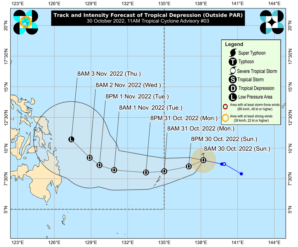
Meanwhile, PAGASA continues to monitor a tropical depression still outside PAR, last spotted 1,250 kilometers east of northeastern Mindanao on Sunday morning.
The tropical depression is moving west northwest at a slightly faster 15 km/h from the previous 10 km/h.
It is seen to enter PAR on Monday morning and would be given the local name Queenie.
So far, the tropical depression has maximum sustained winds of 45 km/h and gustiness of up to 55 km/h.
It is projected to remain a tropical depression until Tuesday, then weaken into a remnant low on Wednesday, November 2, or Thursday, November 3.
Based on the current forecast, the tropical depression is unlikely to directly affect the country.
– Rappler.com
Add a comment
How does this make you feel?


There are no comments yet. Add your comment to start the conversation.