SUMMARY
This is AI generated summarization, which may have errors. For context, always refer to the full article.
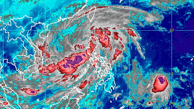
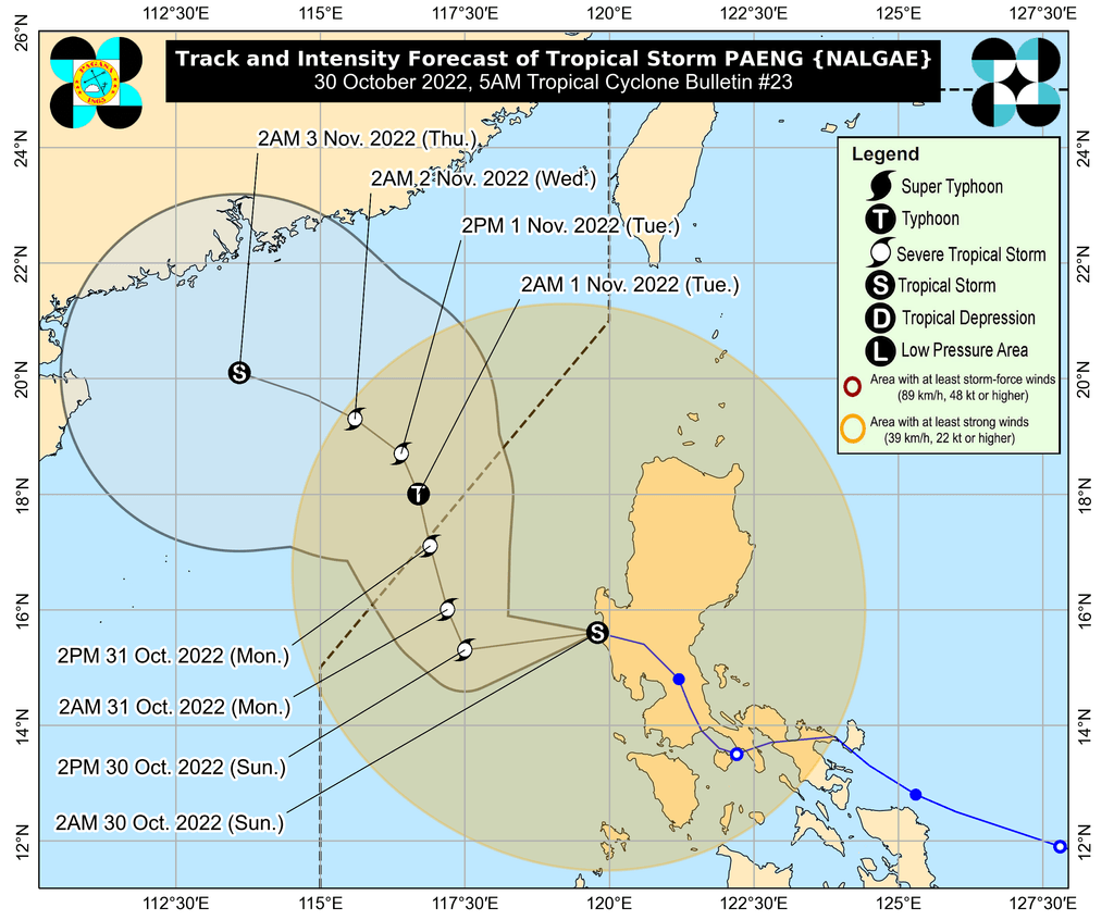
MANILA, Philippines – Tropical Storm Paeng (Nalgae) left the landmass of Luzon at 2 am on Sunday, October 30, and is already over the West Philippine Sea.
Paeng was last spotted 85 kilometers west northwest of Iba, Zambales, said the Philippine Atmospheric, Geophysical, and Astronomical Services Administration (PAGASA) in a bulletin issued at 5 am on Sunday.
The tropical storm accelerated further, moving west northwest at 30 kilometers per hour from the previous 25 km/h.
It is seen to exit the Philippine Area of Responsibility (PAR) on Monday morning or afternoon, October 31.
Paeng still had maximum sustained winds of 85 km/h early Sunday, while its gustiness was down to 105 km/h. But over the West Philippine Sea, it could re-intensify into a severe tropical storm within 24 hours.
Paeng may also become a typhoon by late Monday evening or on Tuesday morning, November 1, while outside PAR, but it may start weakening again late Tuesday due to another surge of the northeast monsoon or hanging amihan.
Much of Luzon may still see rain from Paeng on Sunday morning, though the intensity of the rainfall is easing.
Moderate to heavy rain
- Zambales
- Bataan
- Aurora
- Pangasinan
- Batanes
- northern part of Cagayan including Babuyan Islands
Light to moderate rain, with at times heavy rain
- Metro Manila
- Cordillera Administrative Region
- Calabarzon
- Mimaropa
- rest of Cagayan Valley
- rest of Central Luzon
- Camarines Norte
- Camarines Sur
- Western Visayas
PAGASA said floods and landslides “are likely to slowly subside,” except in areas which saw significant rainfall the past days or those still hit by persistent heavy rain.
Meanwhile, some areas remain under tropical cyclone wind signals as of 5 am on Sunday:
Signal No. 2
Gale-force winds (62 to 88 km/h), minor to moderate threat to life and property
- Pangasinan
- La Union
- southern part of Ilocos Sur (Candon City, Banayoyo, Galimuyod, Sigay, Suyo, Santa Lucia, Santa Cruz, Alilem, Tagudin, Sugpon, Cervantes, Quirino, Gregorio del Pilar, Salcedo, Lidlidda, San Emilio, Santiago, Burgos, Santa Maria, San Esteban)
- Benguet
- Tarlac
- Zambales
- western part of Bataan (Morong, Bagac, Dinalupihan, Hermosa)
- western part of Pampanga (Floridablanca, Mabalacat City, Magalang, Angeles City, Porac)
- northwestern part of Nueva Ecija (Guimba, Cuyapo, Talugtug, Nampicuan)
Signal No. 1
Strong winds (39 to 61 km/h), minimal to minor threat to life and property
- Cagayan including Babuyan Islands
- Isabela
- Quirino
- Nueva Vizcaya
- Apayao
- Kalinga
- Ifugao
- Mountain Province
- Abra
- Ilocos Norte
- rest of Ilocos Sur
- Aurora
- rest of Nueva Ecija
- rest of Pampanga
- Bulacan
- rest of Bataan
- Metro Manila
- Laguna
- Rizal
- Batangas
- Cavite
- Quezon including Polillo Islands
- Marinduque
- northwestern part of Romblon (Concepcion, Banton, Corcuera)
- Occidental Mindoro including Lubang Islands
- Oriental Mindoro
- Calamian Islands
- Camarines Norte
- northwestern part of Camarines Sur (Lupi, Ragay, Del Gallego, Sipocot)
There are no more storm surge warnings due to Paeng.
But PAGASA issued a new gale warning at 5 am on Sunday, covering these seaboards:
- western seaboards of Northern Luzon and Central Luzon (western coast of Ilocos Norte, Ilocos Sur, La Union, Pangasinan, Zambales, Bataan) – very rough to high seas, waves 4.5 to 7 meters high
- remaining seaboards of Luzon and western seaboard of Visayas (Batanes, Cagayan including Babuyan Islands, Isabela, Aurora, Pampanga, Bulacan, Metro Manila, Cavite, Batangas, Quezon including Polillo Islands, Occidental Mindoro including Lubang Islands, Oriental Mindoro, Marinduque, Romblon, Camarines Norte, Camarines Sur, Catanduanes, Albay, Sorsogon, Masbate including Burias Island and Ticao Island, Aklan, Antique, Capiz, Iloilo, Guimaras, Negros Oriental, Palawan including Calamian, Cuyo, Cagayancillo, and Kalayaan Islands) – rough to very rough seas, waves 3.1 to 5.5 meters high
- eastern seaboard of Visayas (northern and eastern coasts of Northern Samar, eastern coast of Eastern Samar) – rough seas, waves 2.8 to 4 meters high
“Rough to high sea conditions are risky for all types of sea vessels. Mariners are advised to remain in port or take shelter in port until winds and waves subside,” the weather bureau said.
Paeng is the Philippines’ 16th tropical cyclone for 2022 and the fourth for October.
It made landfall five times, all on Saturday, October 29:
- Virac, Catanduanes – 1:10 am
- Caramoan, Camarines Sur – 1:40 am
- Buenavista, Quezon – 6 am
- Santa Cruz, Marinduque – 8:40 am
- Sariaya, Quezon – 1:40 pm
After hitting Quezon for a second time, Paeng crossed Laguna, Cavite, the Metro Manila-Rizal-Bulacan area, Pampanga, and Zambales.
Even before its landfalls in Luzon, Paeng already wreaked havoc in parts of Mindanao and the Visayas.
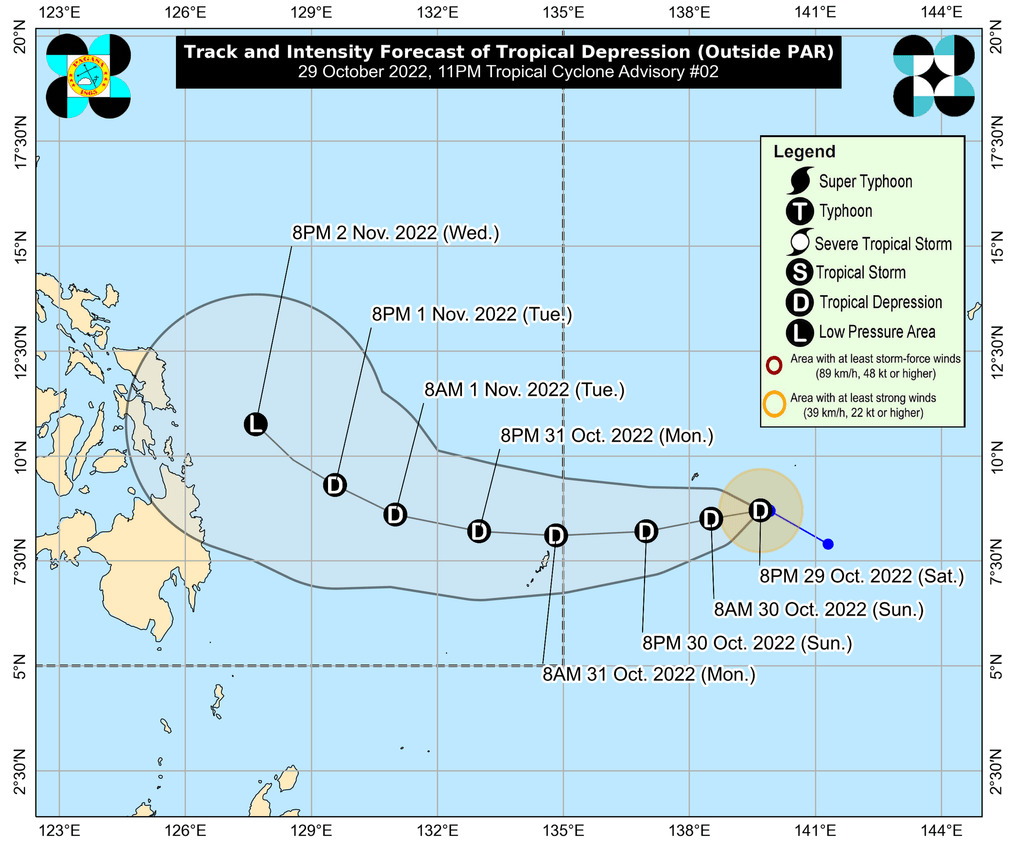
Aside from Paeng, the weather bureau is monitoring a tropical depression outside PAR.
The tropical depression was located 1,385 kilometers east of northeastern Mindanao before dawn on Sunday, moving west northwest at 10 km/h after being almost stationary.
It still has maximum sustained winds of 45 km/h and gustiness of up to 55 km/h.
PAGASA said the tropical depression may enter PAR on Monday morning, and would be given the local name Queenie.
It is projected to remain a tropical depression until Tuesday, and may weaken into a remnant low on Wednesday, November 2.
PAGASA Weather Specialist Benison Estareja explained that sea conditions will not be as favorable for the tropical depression since Paeng already moved over the same area of the Philippine Sea, reducing the moisture there.
The trough or extension of the new weather system, however, could bring some rain. Updates are expected in the coming days.
– Rappler.com
Add a comment
How does this make you feel?


There are no comments yet. Add your comment to start the conversation.