SUMMARY
This is AI generated summarization, which may have errors. For context, always refer to the full article.
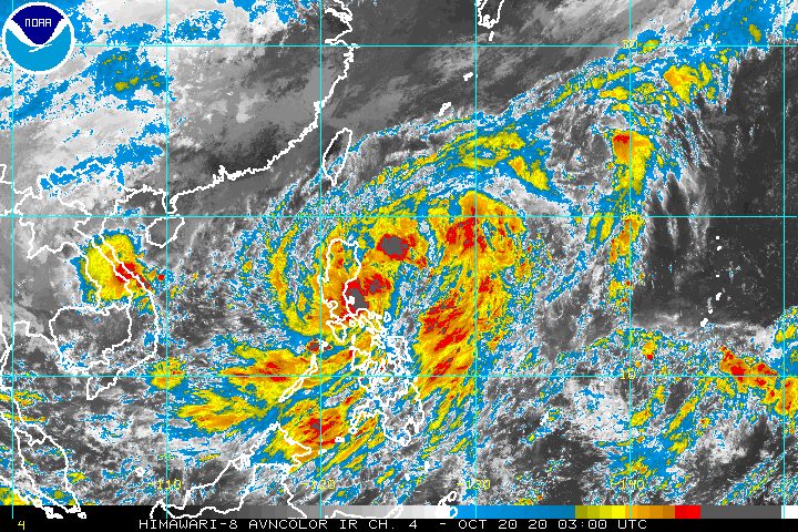
Pepito intensified from a tropical depression into a tropical storm at 8 am on Tuesday, October 20, as it moved toward the provinces of Isabela and Aurora.
It was given the international name Saudel, a name contributed by Micronesia, according to Weather Specialist Ariel Rojas of the Philippine Atmospheric, Geophysical, and Astronomical Services Administration (PAGASA).
In a bulletin released past 11 am on Tuesday, PAGASA said Pepito is already 295 kilometers east of Baler, Aurora.
The tropical storm is moving northwest, still at 25 kilometers per hour (km/h).
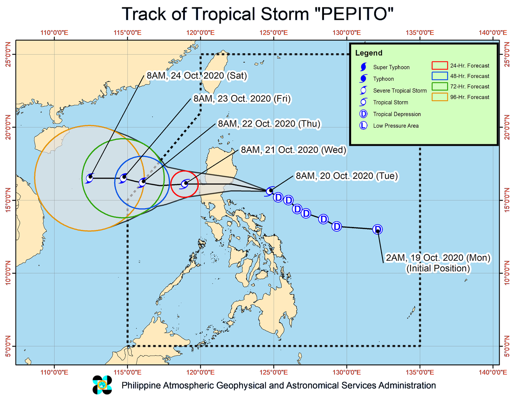
If Pepito generally maintains its speed and direction, it could make landfall either in Aurora or Isabela between 7 pm and 11 pm on Tuesday, said PAGASA. It would then cross the Luzon landmass, and emerge over the West Philippine Sea on Wednesday morning, October 21.
Pepito’s maximum winds have increased to 65 km/h from 55 km/h, while its gustiness is now up to 80 km/h from 70 km/h. It is expected to intensify again after leaving the Luzon landmass, possibly strengthening into a severe tropical storm by Thursday, October 22.
As Pepito became a tropical storm, Signal No. 2 was also raised for the first time due to the weather disturbance. Here is the updated list of areas under tropical cyclone wind signals as of 11 am on Tuesday.
Signal No. 2 (winds of 60 to 120 km/h)
- La Union
- Ifugao
- Benguet
- Nueva Vizcaya
- Quirino
- Pangasinan
- Nueva Ecija
- Tarlac
- Aurora
- southern part of Isabela (Palanan, San Mariano, Benito Soliven, Naguilian, Gamu, Burgos, San Manuel, Aurora, Cabatuan, Luna, Reina Mercedes, Cauayan City, Dinapigue, San Guillermo, Angadanan, Alicia, San Mateo, Ramon, San Isidro, Echague, San Agustin, Jones, Santiago City, Cordon)
- southern part of Ilocos Sur (Sugpon, Alilem, Tagudin)
- northern part of Zambales (Iba, Palauig, Masinloc, Candelaria, Santa Cruz, Botolan, Cabangan)
- northern part of Quezon (General Nakar) including Polillo Island
Signal No. 1 (winds of 30 to 60 km/h)
- Abra
- Kalinga
- Mountain Province
- Bulacan
- Pampanga
- Bataan
- Metro Manila
- Rizal
- northern part of Camarines Norte (Paracale, Jose Panganiban, Capalonga, Vinzons)
- Catanduanes
- rest of northern part of Quezon (Infanta, Real)
- rest of Ilocos Sur
- rest of Isabela
- rest of Zambales
PAGASA warned that “high to gale-force winds” will be experienced in areas under Signal Nos. 1 and 2.
There will also be “high to gale-force winds with occasional gusts” due to the northeasterly surface windflow in:
- Batanes
- Babuyan Islands
- coastal and/or mountainous areas of mainland Cagayan, Apayao, and Ilocos Norte
As for rainfall, this is PAGASA’s latest forecast for Tuesday:
Moderate to heavy rain
- Bicol
- Mimaropa
- Quezon
- Aurora
- Nueva Ecija
- Nueva Vizcaya
- Quirino
- Isabela
- mainland Cagayan
- Pangasinan
- Benguet
Light to moderate rain, with at times heavy rain
- rest of Luzon
- Western Visayas
- Zamboanga Peninsula
- Bangsamoro Autonomous Region in Muslim Mindanao
Heavy or prolonged rain could cause floods and landslides. (READ: FAST FACTS: Tropical cyclones, rainfall advisories)
Meanwhile, a gale warning remains in effect for the seaboards of the following provinces, due to rough to very rough seas with waves 2.8 to 5 meters high:
- Batanes
- Cagayan
- Ilocos Norte
In seaboards of areas under Signal Nos. 1 and 2, waters are rough to very rough as well, and waves could reach 2.5 to 4.5 meters high. Travel is risky, especially for those using small vessels.
There are also moderate to rough seas, with waves 1.5 to 3 meters high, in these seaboards:
- western and eastern seaboards of Southern Luzon
- eastern seaboards of Eastern Visayas, Caraga, and Davao Region
Precautionary measures are needed for small vessels, said PAGASA. It added that “inexperienced mariners should avoid navigating in these conditions.”
Based on its latest forecast track, Pepito could leave the Philippine Area of Responsibility (PAR) on Thursday morning.
Meanwhile, PAGASA spotted a new tropical depression outside PAR, located 1,735 kilometers east northeast of extreme Northern Luzon.
This tropical depression has maximum winds of 45 km/h and gustiness of up to 55 km/h.
So far, it is moving north northwest at 15 km/h, and is “less likely” to enter PAR, according to the state weather bureau.
Pepito is the Philippines’ 16th tropical cyclone for 2020, and the 3rd for October.
An average of 20 tropical cyclones form within or enter PAR each year. (READ: LIST: PAGASA’s names for tropical cyclones in 2020)
PAGASA gave the following estimates for the number of tropical cyclones inside PAR in the next 6 months:
- October 2020 – 2 or 3
- November 2020 – 1 or 2
- December 2020 – 1 or 2
- January 2021 – 1 or 2
- February 2021 – 0 or 1
- March 2021 – 0 or 1
Last October 2, the state weather bureau warned Filipinos to expect more rain in the coming months due to the onset of La Niña. – Rappler.com
Add a comment
How does this make you feel?


There are no comments yet. Add your comment to start the conversation.