SUMMARY
This is AI generated summarization, which may have errors. For context, always refer to the full article.
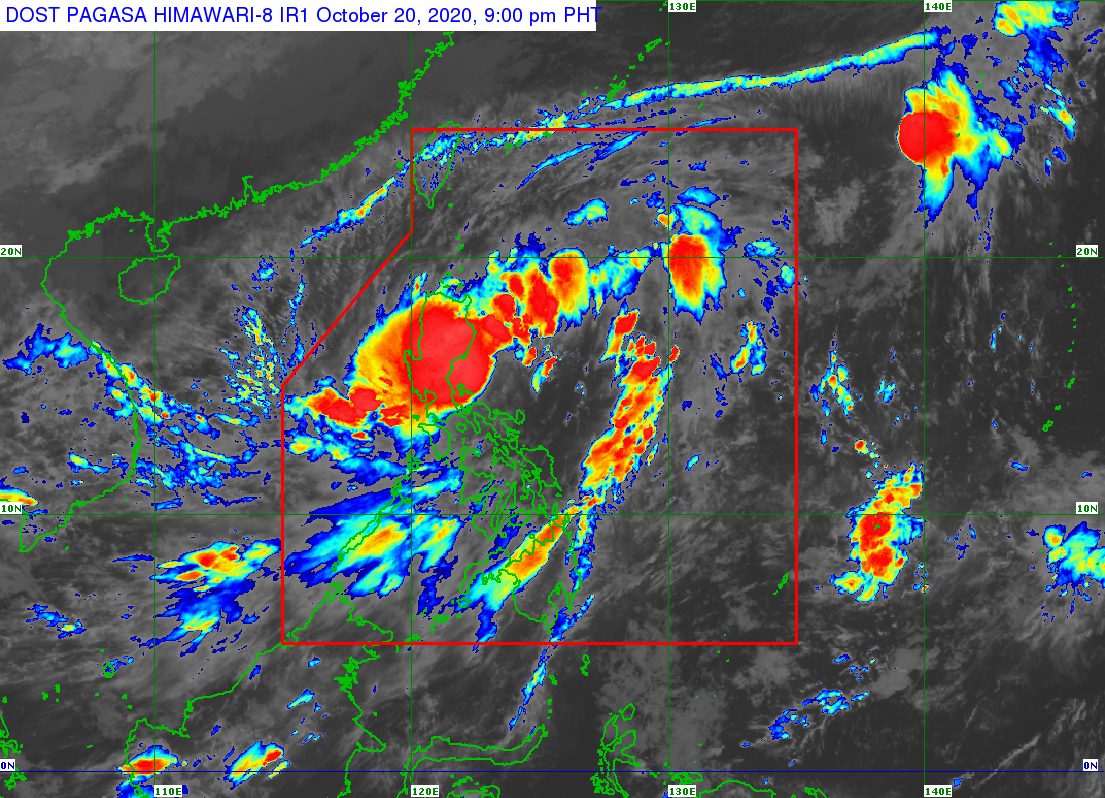
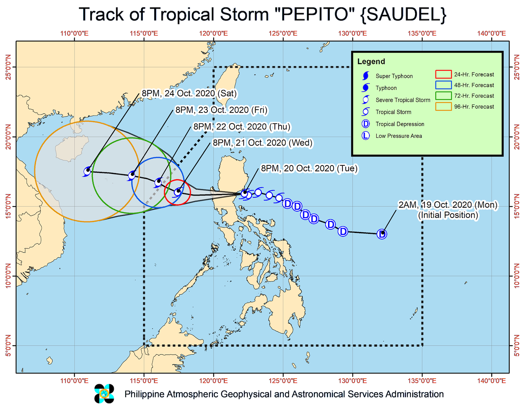
Tropical Storm Pepito (Saudel) made landfall in San Ildefonso Peninsula in Casiguran, Aurora, at 9 pm on Tuesday, October 20, bringing heavy rain and strong winds.
The Philippine Atmospheric, Geophysical, and Astronomical Services Administration (PAGASA) announced the landfall on its social media accounts shortly before 10 pm.
In a separate bulletin at 11 pm, PAGASA said Pepito is already in the vicinity of Dinalungan, Aurora, moving west at 20 kilometers per hour (km/h).
The tropical storm will cross the landmass of Luzon overnight – likely neighboring Quirino next after Aurora – and then emerge over the West Philippine Sea on Wednesday morning, October 21.
The tropical storm’s maximum winds remained at 75 km/h, while its gustiness rose from 90 km/h to 125 km/h.
PAGASA said Pepito will likely maintain its strength while crossing land, though it is also possible that it would slightly weaken. Once Pepito is over the West Philippine Sea, however, it is expected to regain strength and even intensify into a severe tropical storm on Thursday, October 22.
Here are the areas where tropical cyclone wind signals are raised as of 11 pm on Tuesday:
Signal No. 2 (winds of 60 to 120 km/h)
- La Union
- Pangasinan
- Ifugao
- Benguet
- Nueva Vizcaya
- Quirino
- Nueva Ecija
- Tarlac
- Aurora
- southern part of Isabela (Palanan, San Mariano, Benito Soliven, Naguilian, Gamu, Burgos, San Manuel, Aurora, Cabatuan, Luna, Reina Mercedes, Cauayan City, Dinapigue, San Guillermo, Angadanan, Alicia, San Mateo, Ramon, San Isidro, Echague, San Agustin, Jones, Santiago City, Cordon)
- southern part of Ilocos Sur (Sugpon, Alilem, Tagudin)
- northern part of Zambales (Iba, Palauig, Masinloc, Candelaria, Santa Cruz, Botolan, Cabangan)
- northern part of Bulacan (San Miguel, Doña Remedios Trinidad)
- northern part of Pampanga (Candaba, Arayat, Magalang, Mabalacat)
- northern part of Quezon (General Nakar) including Polillo Island
Signal No. 1 (winds of 30 to 60 km/h)
- Abra
- Kalinga
- Mountain Province
- Bataan
- Metro Manila
- Rizal
- rest of northern part of Quezon (Infanta, Real)
- rest of Ilocos Sur
- rest of Isabela
- rest of Pampanga
- rest of Bulacan
- rest of Zambales
“High to gale-force winds” will be experienced in areas under Signal Nos. 1 and 2, warned PAGASA.
Similar wind conditions will also prevail in the rest of Northern Luzon, especially in coastal and mountainous areas, but due to the northeasterly surface windflow.
Areas affected by Pepito were also advised to brace for more rain overnight until Wednesday morning. This could trigger more floods or landslides. (READ: FAST FACTS: Tropical cyclones, rainfall advisories)
Moderate to heavy rain
- Central Luzon
- Cordillera Administrative Region
- northern part of Quezon including Polillo Island
- Nueva Vizcaya
- Quirino
- Isabela
- mainland Cagayan
- La Union
- Pangasinan
Light to moderate rain, with at times heavy rain
- rest of Luzon
- Western Visayas
- Zamboanga Peninsula
- Bangsamoro Autonomous Region in Muslim Mindanao
In addition, a gale warning is in place for these seaboards, which have rough to very rough waters and waves 2.8 to 5.5 meters high:
- seaboards of Batanes, Cagayan, and Ilocos Norte
- western seaboards of Batangas, Occidental Mindoro (including Lubang Island), and Palawan (including Calamian Islands)
In seaboards of areas under Signal Nos. 1 and 2, waters are rough to very rough as well, and waves could reach 2.5 to 5.5 meters high. Travel is risky, especially for those using small vessels.
There are also moderate to rough seas, with waves 1.5 to 3 meters high, in these areas:
- Palawan
- eastern seaboards of Southern Luzon, Eastern Visayas, Caraga, and Davao Region
Precautionary measures are needed for small vessels, said PAGASA. It added that “inexperienced mariners should avoid navigating in these conditions.”
Pepito could exit the Philippine Area of Responsibility (PAR) on Thursday morning or afternoon.
Meanwhile, PAGASA continues to monitor a tropical depression outside PAR, which is now 1,825 kilometers east northeast of Basco, Batanes.
This tropical depression slightly intensified, and now has maximum winds of 55 km/h and gustiness of up to 70 km/h.
PAGASA said the tropical depression is almost stationary or hardly moving at the moment, but it remains “less likely” to enter PAR.
Pepito is the Philippines’ 16th tropical cyclone for 2020, and the 3rd for October.
An average of 20 tropical cyclones form within or enter PAR each year. (READ: LIST: PAGASA’s names for tropical cyclones in 2020)
PAGASA gave the following estimates for the number of tropical cyclones inside PAR in the next 6 months:
- October 2020 – 2 or 3
- November 2020 – 1 or 2
- December 2020 – 1 or 2
- January 2021 – 1 or 2
- February 2021 – 0 or 1
- March 2021 – 0 or 1
Last October 2, the state weather bureau warned Filipinos to expect more rain in the coming months due to the onset of La Niña. – Rappler.com
Add a comment
How does this make you feel?


There are no comments yet. Add your comment to start the conversation.