SUMMARY
This is AI generated summarization, which may have errors. For context, always refer to the full article.
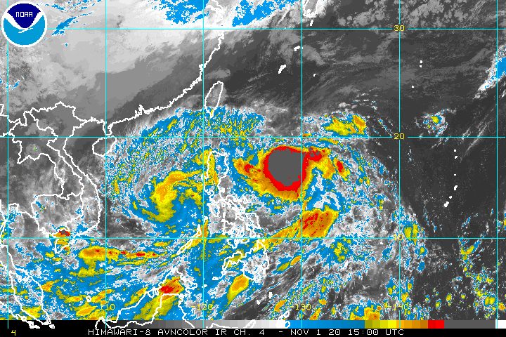
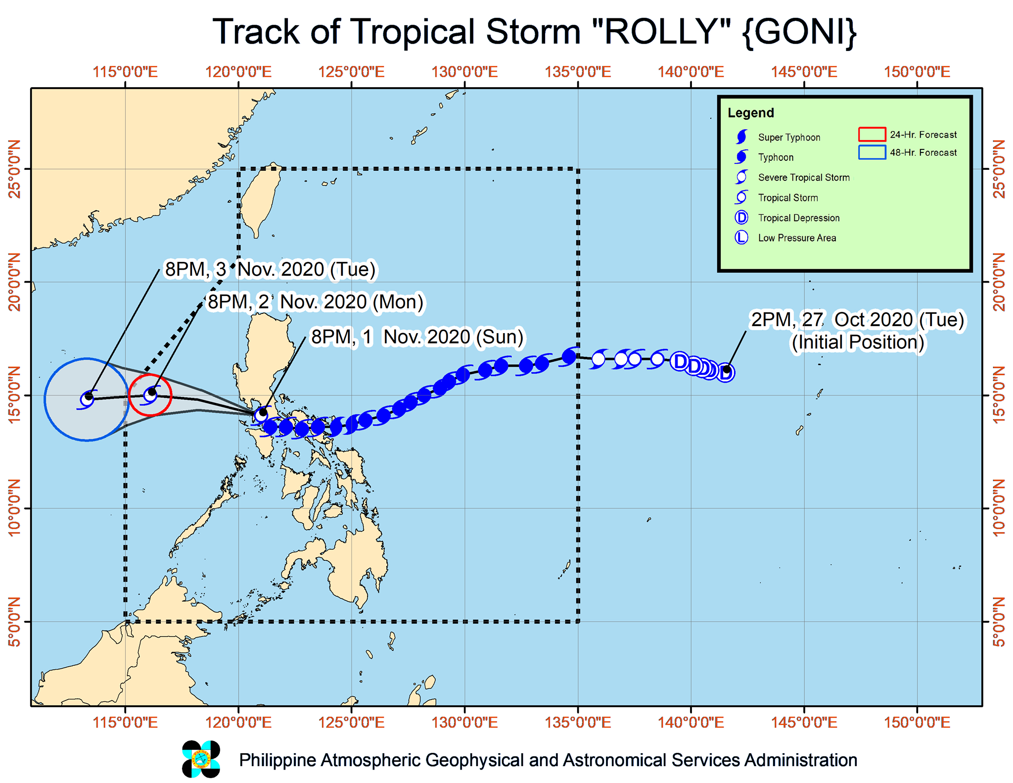
Rolly (Goni), which made landfall as a super typhoon considered the world’s strongest tropical cyclone so far in 2020, rapidly weakened on Sunday evening, November 1.
From typhoon status when it left the landmass of Luzon on Sunday evening, it is now just a tropical storm over the West Philippine Sea.
In its 11 pm bulletin on Sunday, the Philippine Atmospheric, Geophysical, and Astronomical Services Administration (PAGASA) said Rolly is already 150 kilometers northwest of Calapan City, Oriental Mindoro, or 90 kilometers west southwest of Sangley Point, Cavite.
The now-tropical storm slightly slowed down, moving northwest at 20 kilometers per hour (km/h) from the previous 25 km/h.
It currently has maximum sustained winds of 85 km/h and gustiness of up to 105 km/h. When Rolly first hit land as a super typhoon before dawn on Sunday, it had maximum sustained winds of 225 km/h and gustiness of up to 280 km/h. (READ: FAST FACTS: Tropical cyclones, rainfall advisories)
Rolly made landfall in Luzon 4 times on Sunday:
- Bato, Catanduanes – 4:50 am (super typhoon)
- Tiwi, Albay – 7:20 am (super typhoon)
- San Narciso, Quezon – 12 pm (typhoon)
- Lobo, Batangas – 5:30 pm (typhoon)
With Rolly weakening into a tropical storm, there are no more areas under Signal No. 3. Below are the places still under tropical cyclone wind signals as of 11 pm.
Signal No. 2 (gale-force winds)
- western part of Cavite (Naic, Indang, Mendez, Tagaytay City, Amadeo, Ternate, Maragondon, General Emilio Aguinaldo, Magallanes, Alfonso)
- western part of Batangas (Tingloy, Bauan, Mabini, San Luis, Santa Teresita, Taal, San Nicolas, Agoncillo, Laurel, Talisay, Calaca, Lemery, Tuy, Balayan, Nasugbu, Lian, Calatagan)
- northern part of Occidental Mindoro (Abra de Ilog, Mamburao, Paluan) including Lubang Island
Signal No. 1 (strong breeze to near gale conditions)
- central part of Occidental Mindoro (Sablayan, Santa Cruz)
- northern part of Oriental Mindoro (Victoria, Naujan, Calapan City, Baco, San Teodoro, Puerto Galera)
- rest of Batangas
- Laguna
- northern and western parts of Quezon (Sampaloc, Lucban, Sariaya, Lucena City, Tayabas City, Dolores, Candelaria, Tiaong, San Antonio, Real, General Nakar, Infanta)
- rest of Cavite
- Rizal
- Metro Manila
- Bulacan
- Pampanga
- Bataan
- southern part of Zambales (San Marcelino, San Felipe, San Narciso, San Antonio, Castillejos, Subic, Olongapo City)
PAGASA added that strong breeze to near gale conditions due to the northeasterlies will be experienced in the following areas:
- Batanes
- Babuyan Islands
- Ilocos Region
- Cordillera Administrative Region
- northern part of mainland Cagayan
Overnight until Monday morning, November 2, light to moderate rain – possibly heavy at times – may be experienced in these regions:
- Ilocos Region
- Cordillera Administrative Region
- Cagayan Valley
- Central Luzon
There were no more storm surge warnings as of 11 pm.
But PAGASA warned that travel remains risky due to rough to very rough seas, with waves 2.5 to 5 meters high, in the following:
- seaboards of Northern Luzon and Central Luzon
- western seaboards of Batangas, Occidental Mindoro, Burias Island, and Calamian Islands
- eastern seaboards of Quezon including Polillo Island and Bicol
Moderate to rough seas, with waves 1.2 to 2.5 meters high, will also be experienced here:
- western seaboards of Palawan including Kalayaan Islands
- eastern seaboards of Visayas and of Mindanao
PAGASA advised those using small vessels to take precautionary measures, while “inexperienced mariners should avoid navigating in these conditions.”
Rolly is expected to exit the Philippine Area of Responsibility (PAR) on Tuesday morning, November 3, likely staying a tropical storm.
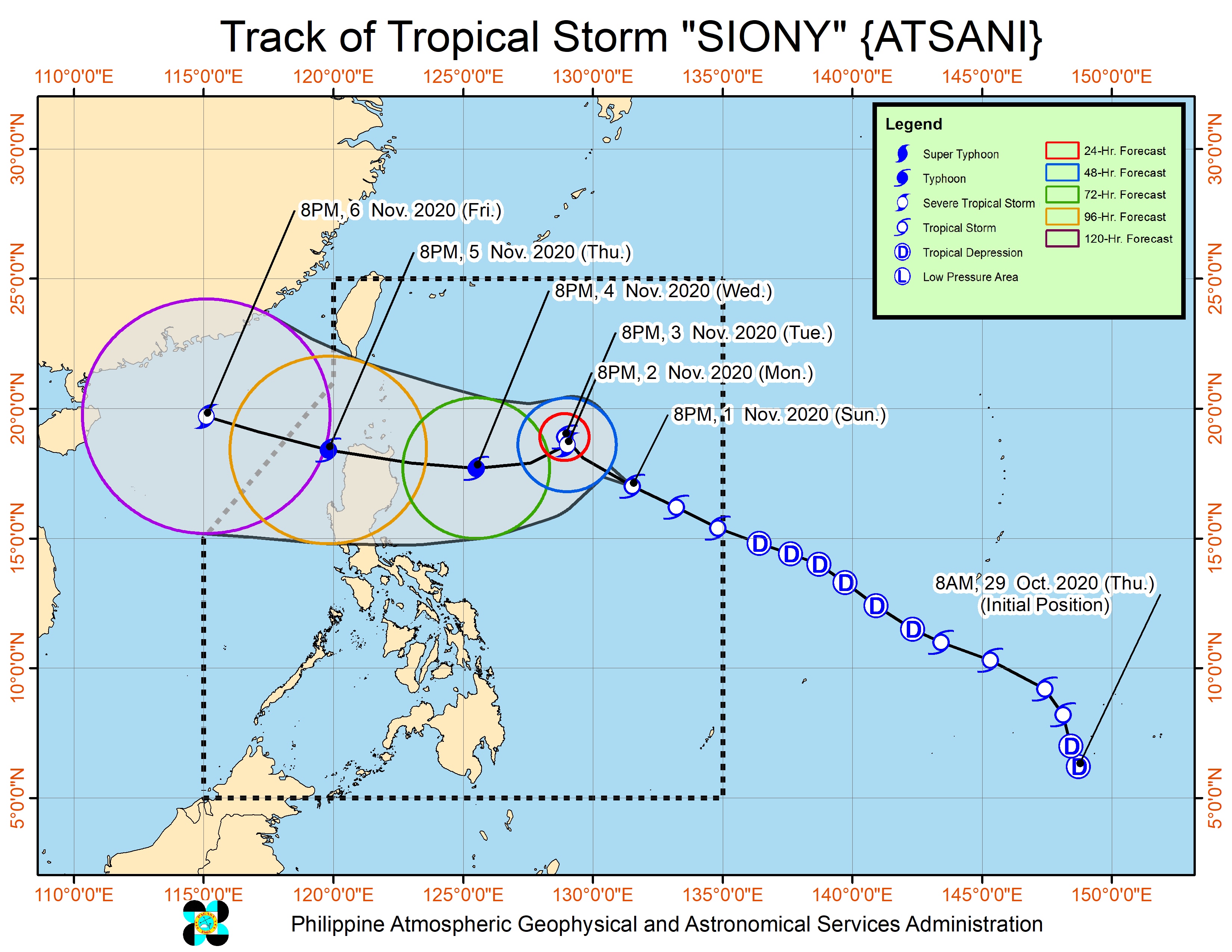
Meanwhile, Tropical Storm Siony (Atsani) is now 990 kilometers east of Northern Luzon, still moving west northwest over the Philippine Sea at 30 km/h.
PAGASA said in a separate 11 pm bulletin on Sunday that Siony is seen to maintain its direction until Monday evening, before it “slows down significantly and becomes almost stationary” on Monday evening until Tuesday evening.
Then Siony could shift west southwest or west toward extreme Northern Luzon.
“Due to the projected erratic movement of this system in the next 48 hours, there is high degree of uncertainty in the forecast track,” PAGASA said.
Siony slightly weakened on Sunday evening. It now has maximum sustained winds of 65 km/h from the previous 75 km/h and gustiness of up to 80 km/h from the previous 90 km/h.
PAGASA said Siony is likely to remain a tropical storm within the next 36 to 48 hours. But it may intensify into a severe tropical storm when it becomes almost stationary on Tuesday.
For now, there are no tropical cyclone wind signals raised due to Siony and no rainfall warnings.
“Siony remains less likely to directly affect the weather and coastal water conditions in the country over the next 2 to 3 days. However, the public and disaster managers, especially those situated in Northern Luzon, are advised to continue monitoring for updates on this tropical cyclone,” PAGASA said.
Rolly is the Philippines’ 18th tropical cyclone for 2020, while Siony is the 19th.
An average of 20 tropical cyclones form within or enter PAR each year. (READ: LIST: PAGASA’s names for tropical cyclones in 2020)
These are PAGASA’s latest estimates for the number of tropical cyclones inside PAR in the next 6 months:
- November 2020 – 1 to 3
- December 2020 – 2 or 3
- January 2021 – 0 or 1
- February 2021 – 0 or 1
- March 2021 – 0 or 1
- April 2021 – 0 or 1
Last October 2, the state weather bureau warned Filipinos to expect more rain in the coming months due to the onset of La Niña. – Rappler.com
Add a comment
How does this make you feel?


There are no comments yet. Add your comment to start the conversation.