SUMMARY
This is AI generated summarization, which may have errors. For context, always refer to the full article.
Most of the Bicol region was placed under Signal No. 2 on Tuesday afternoon, November 10, due to Tropical Storm Ulysses (Vamco), which strengthened further over the Philippine Sea.
The Philippine Atmospheric, Geophysical, and Astronomical Services Administration (PAGASA) said in a briefing past 5 pm on Tuesday that Ulysses now has maximum sustained winds of 85 kilometers per hour (km/h) and gustiness of up to 105 km/h.
Earlier on Tuesday morning, it had maximum sustained winds of 75 km/h and gustiness of up to 90 km/h. (READ: FAST FACTS: Tropical cyclones, rainfall advisories)
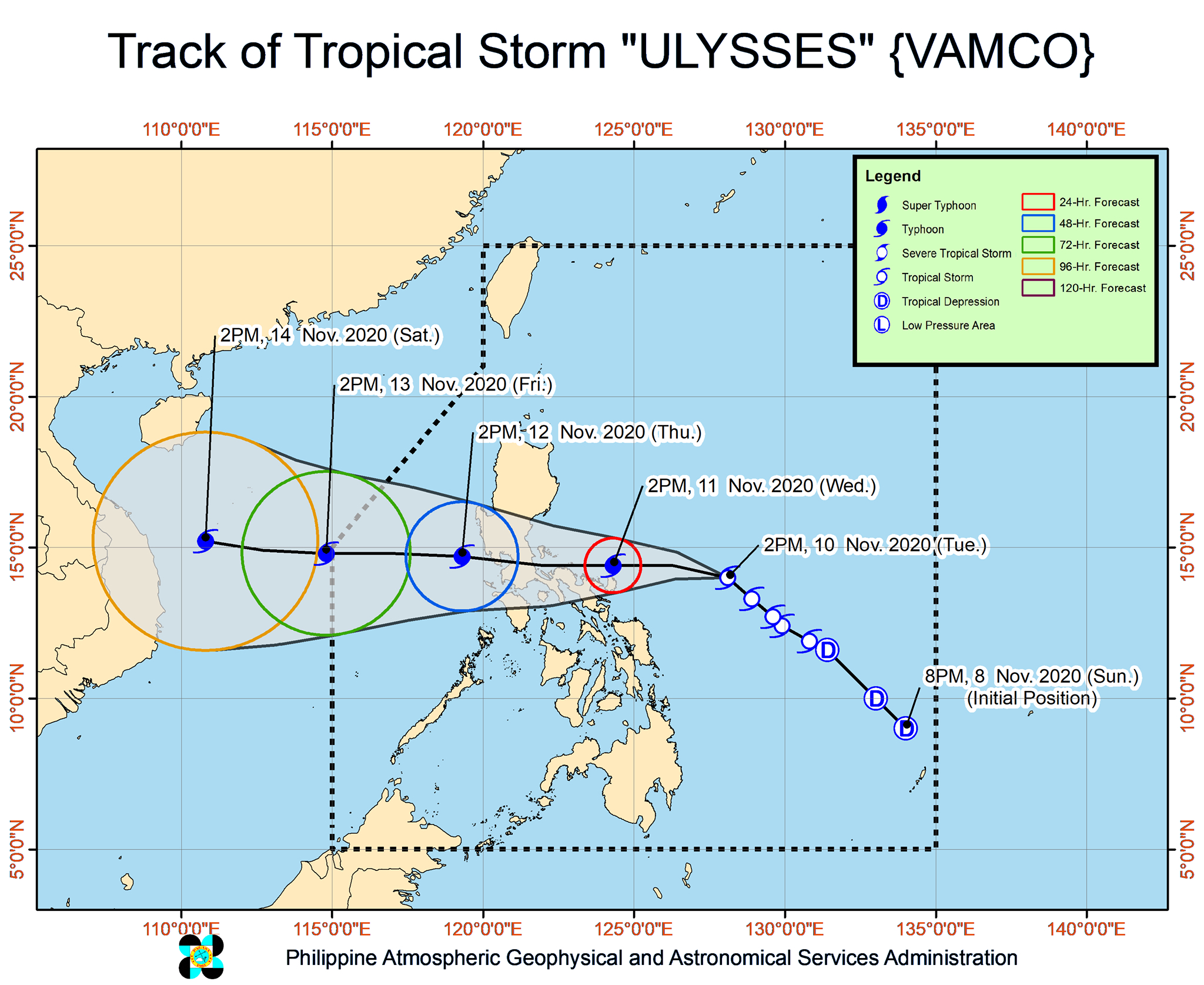
It is also not yet done gaining strength, warned PAGASA. Ulysses is expected to intensify into a severe tropical storm on Tuesday evening, and then into a typhoon by Wednesday morning, November 11.
It could reach its peak intensity of 130 to 155 km/h on Wednesday afternoon or evening, and it is “highly likely” to make landfall at or near that intensity.
Ulysses could make landfall in Bicol on Wednesday afternoon or evening, or possibly in the province of Quezon early Thursday morning, November 12. Even if its landfall is in Quezon, it would still be very near Catanduanes on Wednesday afternoon and Camarines Norte on Wednesday evening.
As of Tuesday afternoon, Ulysses was located 375 kilometers east northeast of Virac, Catanduanes, or 500 kilometers east of Daet, Camarines Norte.
It is moving northwest, maintaining its speed of 15 km/h.
Here is the list of areas under tropical cyclone wind signals as of 5 pm on Tuesday.
Signal No. 2
- Catanduanes
- Sorsogon
- Albay
- Camarines Sur
- eastern part of Camarines Norte (San Vicente, Talisay, Daet, San Lorenzo Ruiz, Basud, Mercedes)
Signal No. 1
- Quirino
- Nueva Vizcaya
- eastern part of Pangasinan (San Nicolas, Natividad, San Quintin, Umingan, Balungao, Rosales, Santa Maria, Tayug, Asingan, San Manuel)
- Aurora
- Nueva Ecija
- Tarlac
- Pampanga
- Bulacan
- central and southern parts of Zambales (Masinloc, Palauig, Iba, Botolan, Cabangan, San Felipe, San Narciso, San Marcelino, Castillejos, Subic, Olongapo City, San Antonio)
- Bataan
- Quezon including Polillo Island
- Metro Manila
- Rizal
- Laguna
- Cavite
- Batangas
- rest of Camarines Norte
- Masbate including Ticao and Burias Islands
- Marinduque
- Romblon
- Oriental Mindoro
- Occidental Mindoro including Lubang Island
- Northern Samar
- northern part of Samar (Santo Niño, Almagro, Tagapul-an, Tarangnan, Calbayog City, Santa Margarita, Gandara, Pagsanghan, San Jorge, San Jose de Buan, Matuguinao)
- northern part of Eastern Samar (Maslog, Dolores, Oras, San Policarpo, Arteche, Jipapad)
PAGASA said areas under Signal No. 2 should brace for damaging gale- to storm-force winds, while those under Signal No. 1 will have strong breeze to near gale conditions during the passage of Ulysses.
The highest possible tropical cyclone wind signal that could be raised due to Ulysses is Signal No. 3.
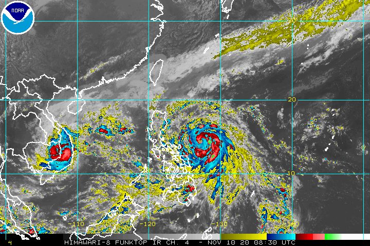
For Tuesday evening, PAGASA said Ulysses’ outer rainbands and the tail-end of a cold front will continue to bring light to moderate rain. The rain may also be heavy at times, so there is already a threat of floods and landslides.
Due to Ulysses
- Aurora
- Quezon
- Bicol
- Eastern Visayas
- Central Visayas
- Caraga
- Northern Mindanao
- Zamboanga Peninsula
- Bangsamoro Autonomous Region in Muslim Mindanao
Due to tail-end of a cold front
- Cagayan including Babuyan Islands
- Isabela
- Apayao
- Ilocos Norte
In addition, the state weather bureau warned of a “moderate to high risk” of storm surges 1 to 2 meters high in the next 48 hours. These are the potential areas:
- coastal areas of Calabarzon, Aurora, Camarines Norte, Camarines Sur, Catanduanes, Albay, Metro Manila, Bulacan, Pampanga, Bataan, Romblon, and Marinduque
- western coastal area of Masbate including Burias Island
- northern coastal areas of Occidental Mindoro and Oriental Mindoro including Lubang Island
“These storm surges, which may be accompanied by swells and breaking waves reaching the coast, can cause life-threatening and damaging coastal inundation,” PAGASA said.
Travel also remains risky in the next 24 hours, especially for small vessels, in the seaboards listed below.
Rough to very rough seas (waves 2.5 to 5 meters high)
Due to Ulysses
- seaboards of areas under Signal Nos. 1 and 2
- eastern seaboard of Eastern Samar (parts that are not under a tropical cyclone wind signal)
Due to surge of northeast monsoon
- seaboards of Northern Luzon
- seaboards of Kalayaan Islands
Elsewhere, PAGASA advised small vessels to take precautionary measures as the country’s remaining seaboards will have moderate to rough waters.
Ulysses could exit the Philippine Area of Responsibility (PAR) on Friday, November 13.
Ulysses is the Philippines’ 21st tropical cyclone for 2020 – already above the yearly average of 20. (READ: LIST: PAGASA’s names for tropical cyclones in 2020)
For the next 6 months, these are PAGASA’s estimates for tropical cyclones inside PAR:
- November 2020 – 1 to 3
- December 2020 – 2 or 3
- January 2021 – 0 or 1
- February 2021 – 0 or 1
- March 2021 – 0 or 1
- April 2021 – 0 or 1
Since October, La Niña has been underway, which means there is more rain than usual.
Then in November, the northeast monsoon began, signaling “surges of cold temperatures.”
PAGASA warned that La Niña may enhance the northeast monsoon, which could trigger floods and landslides. – Rappler.com
Add a comment
How does this make you feel?


There are no comments yet. Add your comment to start the conversation.