SUMMARY
This is AI generated summarization, which may have errors. For context, always refer to the full article.
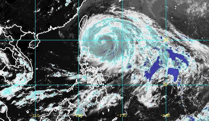
MANILA, Philippines – Typhoon Betty (Mawar) continued to slow down over the waters east of Cagayan on Monday afternoon, May 29, moving north northwest at only 10 kilometers per hour from its previous speed of 15 km/h.
The Philippine Atmospheric, Geophysical, and Astronomical Services Administration (PAGASA) said in its 5 pm bulletin on Monday that Betty was located 445 kilometers east of Calayan, Cagayan.
The typhoon is staying away from land, but “strong to typhoon-force winds extend outwards up
to 770 kilometers” from its center.
It still has maximum sustained winds of 155 km/h and gustiness of up to 190 km/h.
The same areas remain under tropical cyclone wind signals as of 5 pm on Monday:
Signal No. 2
Gale-force winds (62 to 88 km/h), minor to moderate threat to life and property
- Batanes
- northeastern part of Cagayan (Santa Ana, Gonzaga) including Babuyan Islands
Signal No. 1
Strong winds (39 to 61 km/h), minimal to minor threat to life and property
- rest of mainland Cagayan
- Isabela
- Apayao
- Ilocos Norte
- Abra
- Kalinga
- Mountain Province
- Ifugao
- northern and central parts of Aurora (Dilasag, Casiguran, Dinalungan, Dipaculao, Baler)
- Quirino
- northeastern part of Nueva Vizcaya (Kasibu, Quezon, Solano, Bagabag, Diadi, Villaverde, Bayombong, Ambaguio)
- northern part of Catanduanes (Caramoran, Viga, Gigmoto, Panganiban, Bagamanoc, Pandan)
- northeastern part of Camarines Sur (Caramoan, Garchitorena, Lagonoy, Tinambac, Siruma)
- northern part of Camarines Norte (Vinzons, Paracale, Jose Panganiban, Capalonga, Talisay, Daet, Mercedes, Basud)
- Polillo Islands
- northern and central parts of Ilocos Sur (Gregorio del Pilar, Magsingal, San Esteban, Banayoyo, Cervantes, Burgos, Santiago, San Vicente, Santa Catalina, Lidlidda, Nagbukel, Sinait, Sigay, San Ildefonso, Galimuyod, Quirino, Vigan City, San Emilio, Cabugao, Caoayan, San Juan, Santa, Bantay, Santo Domingo, Santa Maria, Narvacan, Salcedo, Candon City)
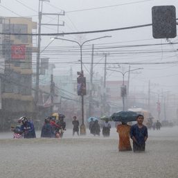
There are also occasional gusts due to the southwest monsoon or habagat, which is being enhanced by Betty. The eastern part of Central Luzon, eastern and southern parts of Southern Luzon that are not under wind signals, and most of the Visayas may be affected on Monday. The western part of Luzon could also experience occasional gusts beginning Tuesday, May 30, or Wednesday, May 31.
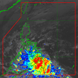
In terms of rainfall, PAGASA’s forecast shows heavy rain in Northern Luzon over the next few days. Floods and landslides are likely.
Monday afternoon, May 29, to Tuesday afternoon, May 30
- 50-100 millimeters (mm): Batanes, eastern part of Babuyan Islands, Ilocos Norte, northern part of Ilocos Sur, nothern part of Apayao, northeastern part of mainland Cagayan
Tuesday afternoon, May 30, to Wednesday afternoon, May 31
- 100-200 mm: Ilocos Norte, Ilocos Sur, La Union, Abra, Benguet, Batanes, eastern part of Babuyan Islands
- 50-100 mm: rest of Babuyan Islands, Apayao, northern part of mainland Cagayan
Wednesday afternoon, May 31, to Thursday afternoon, June 1
- 100-200 mm: Batanes, Ilocos Sur, La Union, western part of Abra, western part of Benguet
- 50-100 mm: Babuyan Islands, rest of Ilocos Region, rest of Abra, rest of Benguet
Thursday afternoon, June 1, to Friday afternoon, June 2
- 50-100 mm: Batanes, Babuyan Islands, Ilocos Region
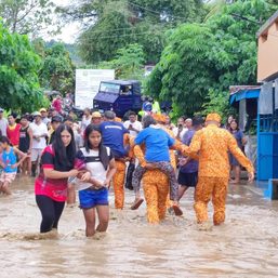
The enhanced southwest monsoon, meanwhile, is affecting Southern Luzon, the Visayas, and Mindanao.
In particular, scattered rainshowers and thunderstorms due to the southwest monsoon may hit Occidental Mindoro, Palawan, Western Visayas, the Zamboanga Peninsula, and the Bangsamoro Autonomous Region in Muslim Mindanao. The rain could be moderate to heavy at times.
Elsewhere, the southwest monsoon may cause just isolated rain showers or thunderstorms. But severe thunderstorms may trigger flash floods and landslides, too.

A fresh gale warning was also issued at 5 pm on Monday due to Betty and the southwest monsoon, covering these seaboards:
- northern and eastern seaboards of Northern Luzon and Central Luzon – rough to high seas, with waves 3.1 to 6.5 meters high
- seaboards of Southern Luzon, seaboards of Visayas, eastern seaboard of Mindanao – rough to very rough seas, with waves 2.8 to 4.5 meters high
“Rough to high sea conditions are risky for all types of sea vessels. Mariners are advised to remain in port or take shelter in port until winds and waves subside,” PAGASA said.
Betty may become slow-moving or almost stationary from Tuesday to Wednesday while east of Batanes.
Then it could turn north northeast or northeast late Wednesday or Thursday, June 1, and gradually speed up toward the waters east of Taiwan and the southern part of Japan’s Ryukyu Islands.
PAGASA also sees Betty steadily weakening in the next five days due to cooler ocean waters and the intrusion of dry air. It might be downgraded to a severe tropical storm late Thursday or early Friday, June 2, and to a tropical storm late Friday or early Saturday, June 3.
At its peak, it was a super typhoon with maximum sustained winds of 215 km/h.
Betty may leave the Philippine Area of Responsibility on Friday, almost a week since it entered PAR early Saturday, May 27.
It is the country’s second tropical cyclone for 2023 and the first super typhoon of the year. – Rappler.com
Add a comment
How does this make you feel?


There are no comments yet. Add your comment to start the conversation.