SUMMARY
This is AI generated summarization, which may have errors. For context, always refer to the full article.
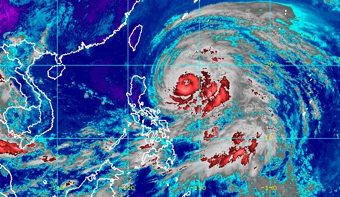
MANILA, Philippines – Typhoon Betty (Mawar) slowed down on Sunday morning, May 28, moving west over the Philippine Sea at only 15 kilometers per hour from the previous 20 km/h.
In its 11 am bulletin on Sunday, the Philippine Atmospheric, Geophysical, and Astronomical Services Administration (PAGASA) said Betty was located 715 kilometers east of Tuguegarao City, Cagayan.
It still has maximum sustained winds of 175 km/h and gustiness of up to 215 km/h.
“Strong to typhoon-force winds extend outwards up to 740 kilometers from the center” of the typhoon, added PAGASA.
The weather bureau earlier said the trough or extension of the typhoon could already bring scattered rainshowers and thunderstorms to Batanes and Cagayan on Sunday.
Landfall remains unlikely, but beginning Monday, May 29, rain directly from Betty is expected to affect the following areas:
Monday morning, May 29, to Tuesday morning, May 30
- 100-200 millimeters (mm): eastern part of Babuyan Islands, northeastern part of mainland Cagayan
- 50-100 mm: Batanes, northwestern part of mainland Cagayan, northern part of Ilocos Norte, northern part of Apayao
Tuesday morning, May 30, to Wednesday morning, May 31
- Greater than 200 mm: Batanes, Babuyan Islands, northern part of Ilocos Norte
- 100-200 mm: northern part of mainland Cagayan, rest of Ilocos Norte, Ilocos Sur, La Union, Abra, Benguet
- 50-100 mm: Pangasinan, rest of mainland Cagayan, rest of Cordillera Administrative Region
Wednesday morning, May 31, to Thursday morning, June 1
- Greater than 200 mm: Batanes, Ilocos Sur, northern part of La Union, northern part of Benguet
- 100-200 mm: Babuyan Islands, Ilocos Norte, Abra, rest of La Union, rest of Benguet
- 50-100 mm: northern part of mainland Cagayan, Pangasinan, rest of Cordillera Administrative Region
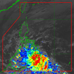
PAGASA also updated its forecast for the southwest monsoon or habagat, which will be enhanced by the typhoon.
Monday, May 29
- monsoon rain possible in western parts of Mimaropa and Western Visayas
Tuesday, May 30
- monsoon rain likely in western parts of Calabarzon, Mimaropa, and Western Visayas
Wednesday, May 31
- monsoon rain likely in Western Visayas and western parts of Central Luzon and Southern Luzon
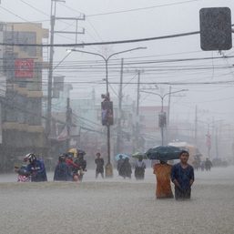
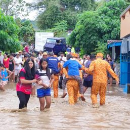
The weather bureau reiterated that floods and landslides are likely in areas set to be affected by Betty and the enhanced southwest monsoon.

As of 11 am on Sunday, there were no changes in the list of areas under Signal No. 1:
- Batanes
- Cagayan including Babuyan Islands
- Isabela
- Apayao
- Ilocos Norte
- northern and central parts of Abra (Tineg, Lacub, Lagayan, San Juan, Lagangilang, Licuan-Baay, Malibcong, Danglas, La Paz, Dolores, Tayum, Bucay, Sallapadan, Daguioman, Bucloc, Boliney)
- Kalinga
- eastern and central parts of Mountain Province (Sadanga, Barlig, Natonin, Paracelis, Bontoc)
- eastern and central parts of Ifugao (Mayoyao, Aguinaldo, Alfonso Lista, Banaue, Hingyon, Lagawe, Lamut, Kiangan, Asipulo)
- northern and central parts of Aurora (Dilasag, Casiguran, Dinalungan, Dipaculao)
- Quirino
- northeastern part of Nueva Vizcaya (Kasibu, Quezon, Solano, Bagabag, Diadi, Villaverde, Bayombong, Ambaguio)
“Minimal to minor impacts caused by strong winds…are possible within any of the areas where [Signal No.1] is currently in effect. Such conditions may begin tonight or tomorrow (Sunday evening or Monday),” PAGASA said.
Signal No. 2 is the “most likely” highest wind signal to be raised due to Betty, though in a worst-case scenario, Signal No. 3 is possible.
PAGASA also said the enhanced southwest monsoon may bring occasional gusts starting Sunday evening or Monday morning to most of the Visayas, the eastern part of Central Luzon, the eastern and southern parts of Southern Luzon, and the northern part of Mindanao.
“The western portion of Luzon may also experience similar conditions beginning on Tuesday or Wednesday (May 30 or 31),” added the weather bureau.

For coastal waters, the gale warning issued at 5 am on Sunday remains in effect:
- northern and eastern seaboards of Luzon (Batanes, Cagayan including Calayan Islands, Isabela, Aurora, northern Quezon [General Nakar] including northern and eastern coasts of Polillo Islands [northern coast of Panukulan, Burdeos, eastern coast of Patnanungan, Jomalig], Camarines Norte, northern coast of Camarines Sur, northern and eastern coasts of Catanduanes, eastern coast of Albay, eastern coast of Sorsogon) – rough to very rough seas, with waves 3.4 to 5.5 meters high
- eastern seaboards of Visayas and Mindanao (northern and eastern coasts of Northern Samar, Eastern Samar, eastern coast of Surigao del Norte including Siargao and Bucas Grande islands, Dinagat Islands) – rough to very rough seas, with waves 3.1 to 5 meters high
PAGASA advised small vessels not to sail and larger vessels to watch out for big waves.
Betty may head west northwest or northwest while gradually decelerating until Monday, then become slow-moving or almost stationary east of Batanes on Tuesday.
By mid-Wednesday or Thursday, June 1, it could move north or north northeast toward the sea east of Taiwan. Taiwan remains within the Philippine Area of Responsibility (PAR).
Betty is expected to gradually weaken until Tuesday, and then weaken at a faster rate on Wednesday or Thursday. By late Thursday or early Friday, June 2, it could be downgraded to a severe tropical storm.
At its peak, it was a super typhoon with maximum sustained winds of 215 km/h.
Betty, which entered PAR as a super typhoon at 2 am on Saturday, May 27, looks set to exit on Friday.
It is the country’s second tropical cyclone for 2023 and the first super typhoon of the year. – Rappler.com
Add a comment
How does this make you feel?


There are no comments yet. Add your comment to start the conversation.