SUMMARY
This is AI generated summarization, which may have errors. For context, always refer to the full article.
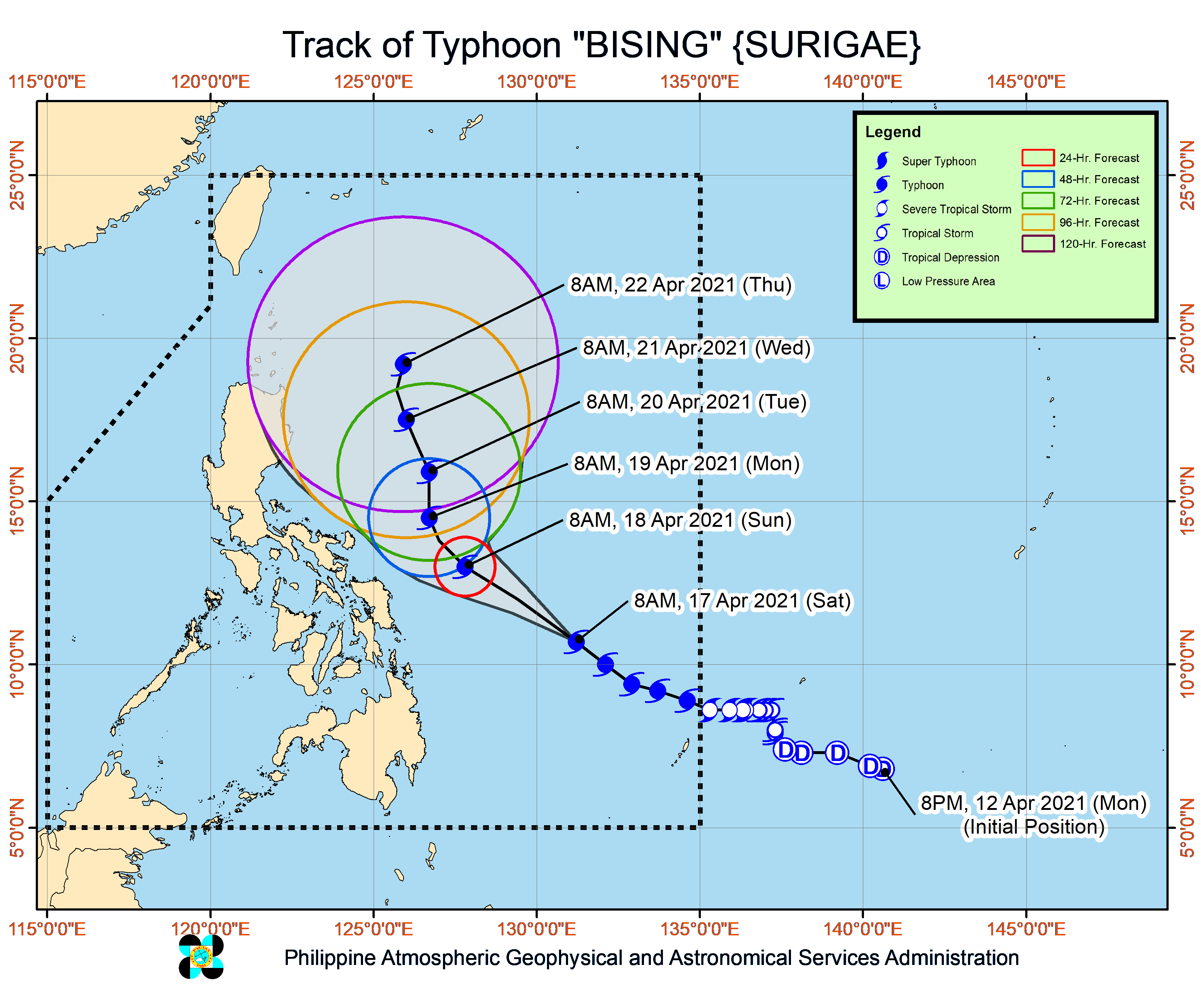
The state weather bureau said “the possibility of a landfall scenario is not ruled out” for Typhoon Bising (Surigae), though the current forecast track still shows it is likely to remain over the Philippine Sea.
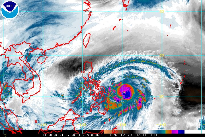
In a bulletin issued 11 am on Saturday, April 17, the Philippine Atmospheric, Geophysical, and Astronomical Services Administration (PAGASA) said Bising is now 645 kilometers east of Maasin City, Southern Leyte, or 545 kilometers east of Guiuan, Eastern Samar.
The typhoon is moving northwest, maintaining its pace of 20 kilometers per hour (km/h). It is expected to keep moving northwest until Sunday afternoon or evening, April 18.
Then it could slow down and move north or north northeast until early Tuesday morning, April 20, before moving north northwest over the Philippine Sea east of Northern Luzon and Central Luzon.
“Considering the uncertainty” in Bising’s forecast track, a shift toward the west or in the direction of land “may result in potentially significant impacts” in the eastern parts of Luzon and the Visayas, warned PAGASA.
Bising also slightly intensified further on Saturday morning. It now has maximum sustained winds of 185 km/h from the previous 175 km/h and gustiness of up to 230 km/h from the previous 215 km/h.
PAGASA said the typhoon’s maximum sustained winds could peak at 195 to 205 km/h on Sunday. (READ: FAST FACTS: Tropical cyclones, rainfall advisories)
Landfall or no landfall, heavy rain and strong winds are expected from Bising. Floods and landslides are potential hazards.
Below is PAGASA’s updated rainfall forecast for the typhoon, beginning Sunday.
Sunday, April 18
Moderate to heavy rain, with at times intense rain
- Eastern Visayas
- Sorsogon
- Masbate
- Albay
- Camarines Sur
- Catanduanes
- Camotes Islands
Monday, April 19
Moderate to heavy rain, with at times intense rain
- Northern Samar
- Bicol
As for winds, these are the areas where Signal No. 1 is raised as of 11 am on Saturday:
- Sorsogon
- Albay
- eastern part of Camarines Sur (Siruma, Goa, Ocampo, Tigaon, Sagñay, Baao, Nabua, Bato, Iriga City, Buhi, Tinambac, Lagonoy, San Jose, Garchitorena, Presentacion, Caramoan)
- Ticao Island
- Catanduanes
- Northern Samar
- Samar
- Eastern Samar
- Biliran
- Leyte
- Southern Leyte
- Camotes Islands
- Dinagat Islands
- Surigao del Norte, including Siargao and Bucas Grande Islands
- Surigao del Sur
PAGASA said tropical cyclone winds that are “at least strong breeze to near gale in strength extend outward up to 550 kilometers” from Bising’s center.
“Destructive typhoon-force winds,” meanwhile, “extend outward up to 70 kilometers” from the center.
Signal No. 2 is still the highest tropical cyclone wind signal expected to be raised due to Bising. But if the typhoon shifts more to the east or veers away from land, the wind signal could remain at just Signal No. 1. If it moves more to the west or toward the direction of land, wind signals could be higher than Signal No. 2.
Travel for all types of vessels also remains risky in the eastern seaboards of the following areas, due to rough to very rough seas on Saturday:
- Bicol (waves 2.5 to 4.5 meters high)
- Eastern Visayas (waves 2.5 to 6.5 meters high)
- Caraga (waves 2.5 to 5.5 meters high)
- Davao Region (waves 2.5 to 3 meters high)
Bising is the Philippines’ second tropical cyclone for 2021. The country usually gets an average of 20 tropical cyclones each year. (READ: LIST: PAGASA’s names for tropical cyclones in 2021)
For the next 6 months, PAGASA estimates the following number of tropical cyclones inside the Philippine Area of Responsibility:
- April – 0 or 1
- May – 0 or 1
- June – 1 or 2
- July – 1 to 3
- August – 2 or 3
- September – 2 or 3
– Rappler.com
Add a comment
How does this make you feel?


There are no comments yet. Add your comment to start the conversation.