SUMMARY
This is AI generated summarization, which may have errors. For context, always refer to the full article.
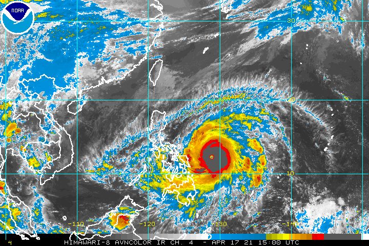
With Typhoon Bising (Surigae) swiftly gaining strength over the Philippine Sea, there is now a possibility that it might reach super typhoon category in the next 24 hours.
The Philippine Atmospheric, Geophysical, and Astronomical Services Administration (PAGASA) said in a bulletin released past 11 pm on Saturday, April 17, that Bising now has maximum sustained winds of 215 kilometers per hour (km/h) and gustiness of up to 265 km/h.
These are compared to maximum sustained winds of 195 km/h and gustiness of up to 240 km/h on Saturday afternoon.
“While the current forecast scenario favors the likelihood of the typhoon maintaining its strength in the next 24 hours, there remains the possibility that Bising will reach super typhoon category during the same period,” PAGASA said.
A super typhoon, the most powerful kind of tropical cyclone, has maximum sustained winds exceeding 220 km/h. (READ: FAST FACTS: Tropical cyclones, rainfall advisories)
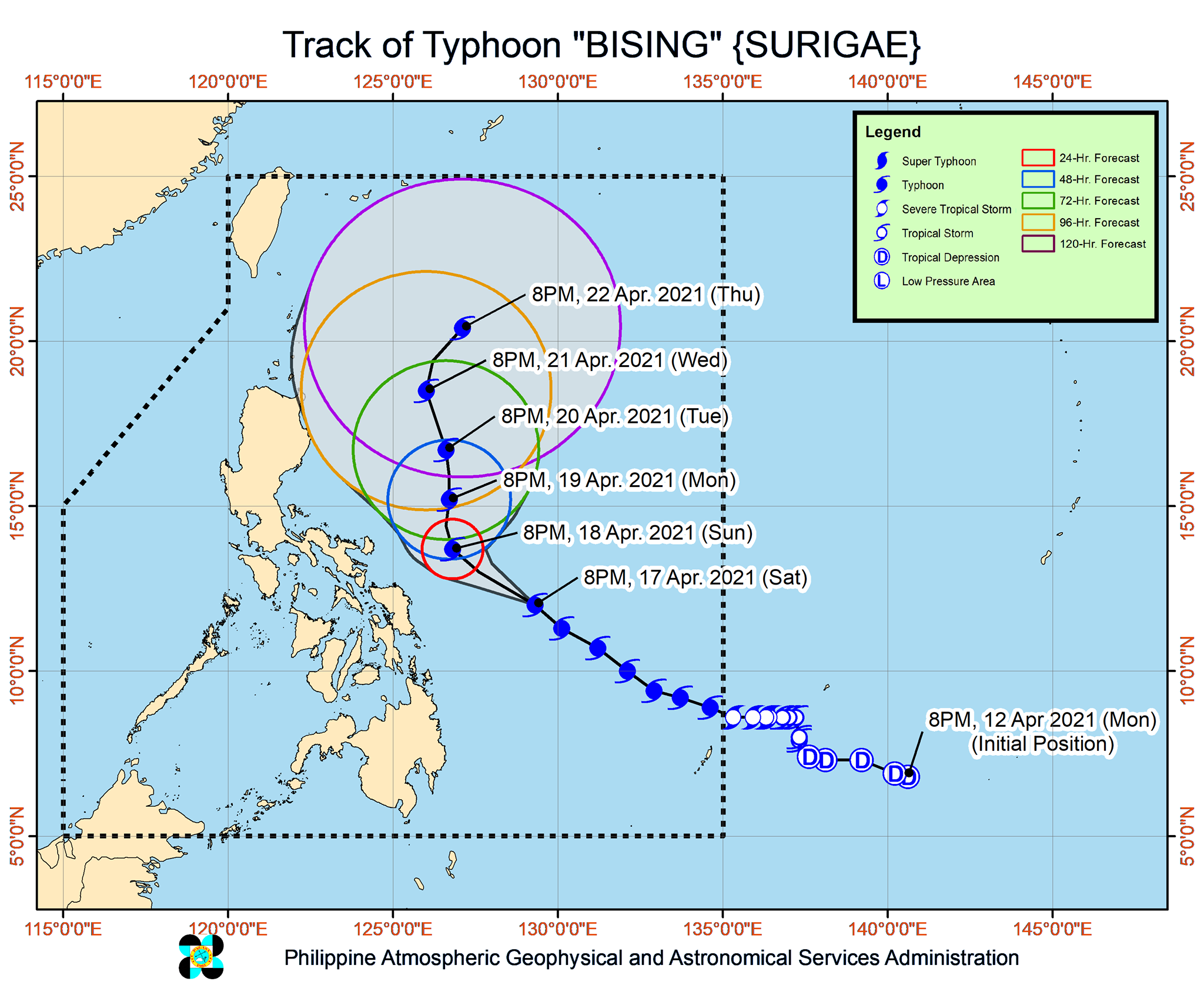
As of Saturday evening, Bising was located 395 kilometers east of Borongan City, Eastern Samar. It slightly slowed down, moving northwest at 20 km/h from the previous 25 km/h.
PAGASA said Bising will continue to move northwest over the Philippine Sea on Sunday, April 18. Starting Sunday afternoon or evening, it is projected to move north while further slowing down.
PAGASA said Bising will be closest to Bicol and Samar Island between Sunday morning and Monday morning, April 19. The state weather bureau stressed that it is not ruling out the possibility of landfall or a close approach in case the typhoon shifts west toward land.
In the event of a westward shift, there could be “potentially significant impacts” in the eastern parts of Southern Luzon and the Visayas, warned PAGASA.
Even without landfall, however, Bising’s effects would still be felt, owing to its wide diameter.
This is PAGASA’s updated rainfall forecast:
Sunday, April 18
Moderate to heavy rain, with at times intense rain
- Eastern Visayas
- Bicol
Monday, April 19
Moderate to heavy rain, with at times intense rain
- Bicol
- Northern Samar
- Samar
- Eastern Samar
Those areas must watch out for floods and landslides.
Meanwhile, the list of areas under tropical cyclone wind signals was further expanded as of 11 pm on Saturday:
Signal No. 2 (winds of 61 to 120 km/h)
- Catanduanes
- Northern Samar
- Eastern Samar
- Samar
Signal No. 1 (winds of 30 to 60 km/h)
- eastern part of Camarines Norte (San Lorenzo Ruiz, San Vicente, Vinzons, Talisay, Daet, Mercedes, Basud)
- Camarines Sur
- Albay
- Sorsogon
- Masbate including Burias and Ticao Islands
- Biliran
- Leyte
- Southern Leyte
- northern part of Cebu (Tabogon, Borbon, San Remigio, Bogo City, Medellin, Daanbantayan), including Bantayan and Camotes Islands
- Dinagat Islands
- Surigao del Norte, including Siargao and Bucas Grande Islands
- Surigao del Sur
PAGASA said tropical cyclone winds that are “at least strong breeze to near gale in strength extend outward up to 440 kilometers” from Bising’s center.
“Destructive typhoon-force winds,” meanwhile, “extend outward up to 110 kilometers” from the center.
Travel is also risky for all types of vessels in the following seaboards:
Very rough to very high seas (waves 3 to 11 meters high)
- northern and eastern seaboards of Eastern Visayas
Rough to very high seas (waves 2.5 to 10 meters high)
- eastern seaboard of Luzon
Rough to very rough seas (waves 3 to 5 meters high)
- eastern seaboard of Caraga
Small vessels would be at risk in these seaboards:
Rough to very rough seas
- northern and western seaboards of Northern Luzon (waves 2.5 to 4.5 meters high)
- eastern seaboard of Davao Region (waves 2.5 to 3.5 meters high)
Moderate to rough seas (waves 1.2 to 2.8 meters high)
- other seaboards of areas under tropical cyclone wind signals
Bising is the Philippines’ second tropical cyclone for 2021. The country usually gets an average of 20 tropical cyclones each year. (READ: LIST: PAGASA’s names for tropical cyclones in 2021)
For the next 6 months, PAGASA estimates the following number of tropical cyclones inside the Philippine Area of Responsibility:
- April – 0 or 1
- May – 0 or 1
- June – 1 or 2
- July – 1 to 3
- August – 2 or 3
- September – 2 or 3
– Rappler.com
Add a comment
How does this make you feel?


There are no comments yet. Add your comment to start the conversation.