SUMMARY
This is AI generated summarization, which may have errors. For context, always refer to the full article.
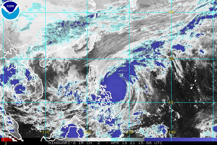
Typhoon Bising (Surigae) slowed down further over the Philippine Sea on Sunday evening, April 18, continuing to trigger rain in Bicol and Eastern Visayas even without making landfall.
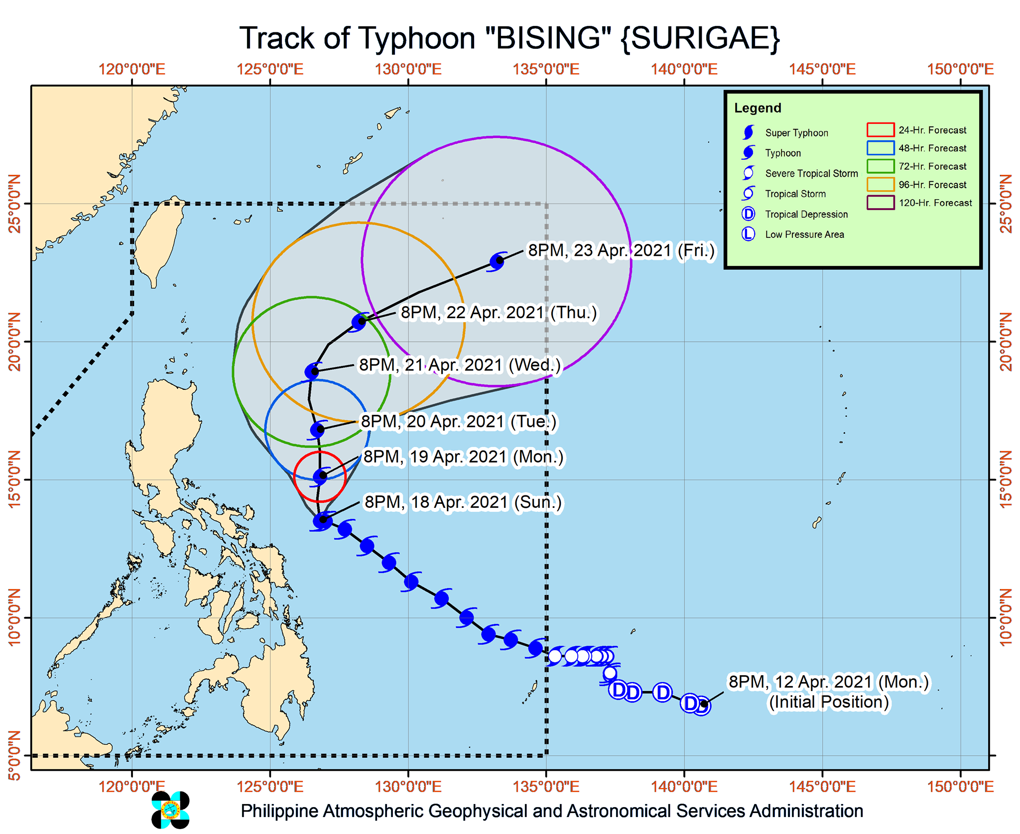
In a bulletin issued 11 pm on Sunday, the Philippine Atmospheric, Geophysical, and Astronomical Services Administration (PAGASA) said Bising was located 270 kilometers east of Virac, Catanduanes, slowly moving west northwest.
The typhoon is expected to maintain its slow pace in the next 6 to 12 hours, added PAGASA, as it begins to shift northward. Then it would keep moving north while gradually speeding up until Wednesday evening, April 21, followed by a turn to the northeast and east northeast, away from Luzon.
Bising also slightly weakened again on Sunday evening, though it remains a strong tropical cyclone. It now has maximum sustained winds of 195 kilometers per hour (km/h) from the previous 205 km/h and gustiness of up to 240 km/h from the previous 250 km/h.
“The recent weakening of Bising after reaching its peak intensity was caused by a recently completed eyewall replacement cycle,” PAGASA explained.
The eyewall “is an organized band of clouds that immediately surround” a tropical cyclone’s eye or center, according to the World Meteorological Organization (WMO). Rain is heaviest and winds are strongest in the eyewall.
The WMO said “eyewall replacement cycles occur when a second concentric eyewall forms around the original and eventually overtakes it.”
PAGASA said Bising is likely to maintain its intensity as of Sunday evening for the next 24 to 48 hours. It is projected to gradually weaken after that. (READ: FAST FACTS: Tropical cyclones, rainfall advisories)
The state weather bureau warned of more rain in the next two days.
Monday, April 19
Moderate to heavy rain, with at times intense rain
- Bicol
- Northern Samar
- Samar
- Eastern Samar
- Biliran
- Leyte
Tuesday, April 20
Moderate to heavy rain
- Bicol
- Northern Samar
PAGASA noted that with more rainfall looming, and given that the affected areas have been experiencing rain since the weekend, floods and landslides “are increasingly likely to occur.”
The state weather bureau also updated the list of areas where tropical cyclone wind signals are raised.
Signal No. 2 (winds of 61 to 120 km/h)
- Catanduanes
- eastern part of Camarines Sur (Garchitorena, Presentacion, Caramoan, Sagñay, San Jose, Lagonoy)
- eastern part of Albay (Tiwi, Malinao, Tabaco City, Malilipot, Santo Domingo, Bacacay, Rapu-Rapu, Legazpi City, Manito)
- eastern and central parts of Sorsogon (Castilla, Sorsogon City, Prieto Diaz, Gubat, Barcelona, Casiguran, Juban, Magallanes, Bulan, Bulusan, Irosin, Santa Magdalena, Matnog)
- Northern Samar
- Samar
- Eastern Samar
- Biliran
Signal No. 1 (winds of 30 to 60 km/h)
- eastern part of Camarines Norte (San Lorenzo Ruiz, San Vicente, Vinzons, Talisay, Daet, Mercedes, Basud)
- rest of Camarines Sur
- rest of Albay
- rest of Sorsogon
- Masbate including Burias and Ticao Islands
- Leyte
- Southern Leyte
- northern part of Cebu (Tabogon, Borbon, San Remigio, Bogo City, Medellin, Daanbantayan), including Bantayan and Camotes Islands
- Dinagat Islands
- Siargao and Bucas Grande Islands
PAGASA said tropical cyclone winds that are “at least strong breeze to near gale in strength extend outward up to 440 kilometers” from Bising’s center.
“Destructive typhoon-force winds,” meanwhile, “extend outward up to 110 kilometers” from the center.
PAGASA added that Bising is enhancing the northeasterly wind flow, which will bring strong breeze to near-gale conditions to the following:
- most of Northern Luzon
- Aurora
- Quezon including Polillo Islands
- remaining parts of Bicol that are not under any tropical cyclone wind signal
Coastal and mountainous areas are more likely to feel the effects of the northeasterly wind flow, according to PAGASA.
Bising and the enhanced northeasterly windflow will continue to affect coastal waters on Monday, April 19, as well.
Travel is risky for all types of vessels in the following seaboards:
Very rough to very high seas (waves 5 to 12 meters high)
- eastern seaboard of Luzon
Rough to very high seas (waves 2.5 to 7 meters high)
- northern and eastern seaboards of Eastern Visayas
Small vessels would be at risk in these seaboards and “mariners without the proper experience should immediately seek safe harbor”:
Rough to very rough seas
- northern and western seaboards of Northern Luzon (waves 2.5 to 5 meters high)
- eastern seaboard of Caraga (waves 2.5 to 4.5 meters high)
Rough seas (waves 2.5 to 4 meters high)
- remaining seaboards of localities under tropical cyclone wind signals
- eastern seaboard of Davao Oriental
Small vessels and inexperienced mariners should avoid sailing here:
Moderate to rough seas (waves 1.2 to 3 meters high)
- western seaboard of Central Luzon
Bising is the Philippines’ second tropical cyclone for 2021. The country usually gets an average of 20 tropical cyclones each year. (READ: LIST: PAGASA’s names for tropical cyclones in 2021)
For the next 6 months, PAGASA estimates the following number of tropical cyclones inside the Philippine Area of Responsibility:
- April – 0 or 1
- May – 0 or 1
- June – 1 or 2
- July – 1 to 3
- August – 2 or 3
- September – 2 or 3
– Rappler.com
Add a comment
How does this make you feel?


There are no comments yet. Add your comment to start the conversation.