SUMMARY
This is AI generated summarization, which may have errors. For context, always refer to the full article.
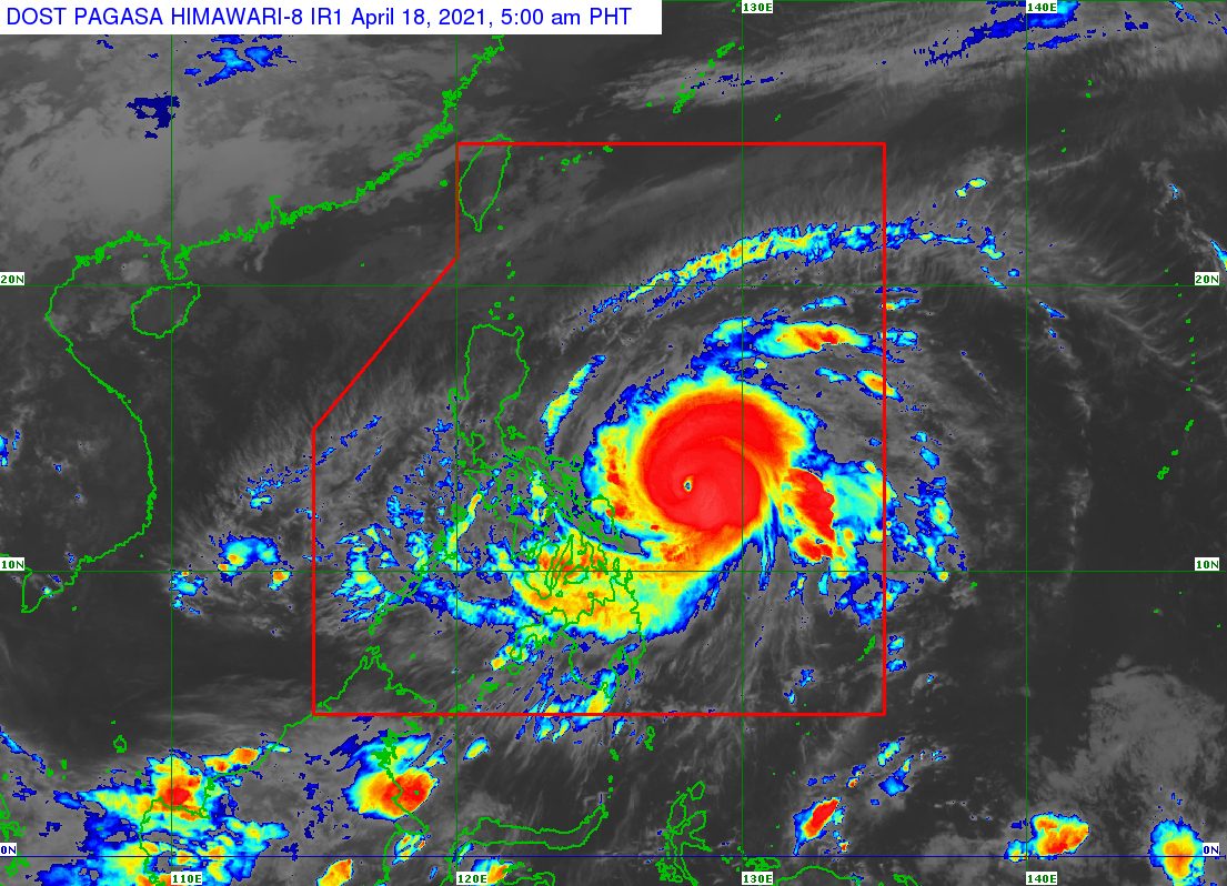
Typhoon Bising (Surigae) slightly slowed down over the Philippine Sea while maintaining its strength before dawn on Sunday, April 18.
In its 5 am bulletin on Sunday, the Philippine Atmospheric, Geophysical, and Astronomical Services Administration (PAGASA) said Bising was located 400 kilometers east of Catarman, Northern Samar, or 470 kilometers east of Juban, Sorsogon.
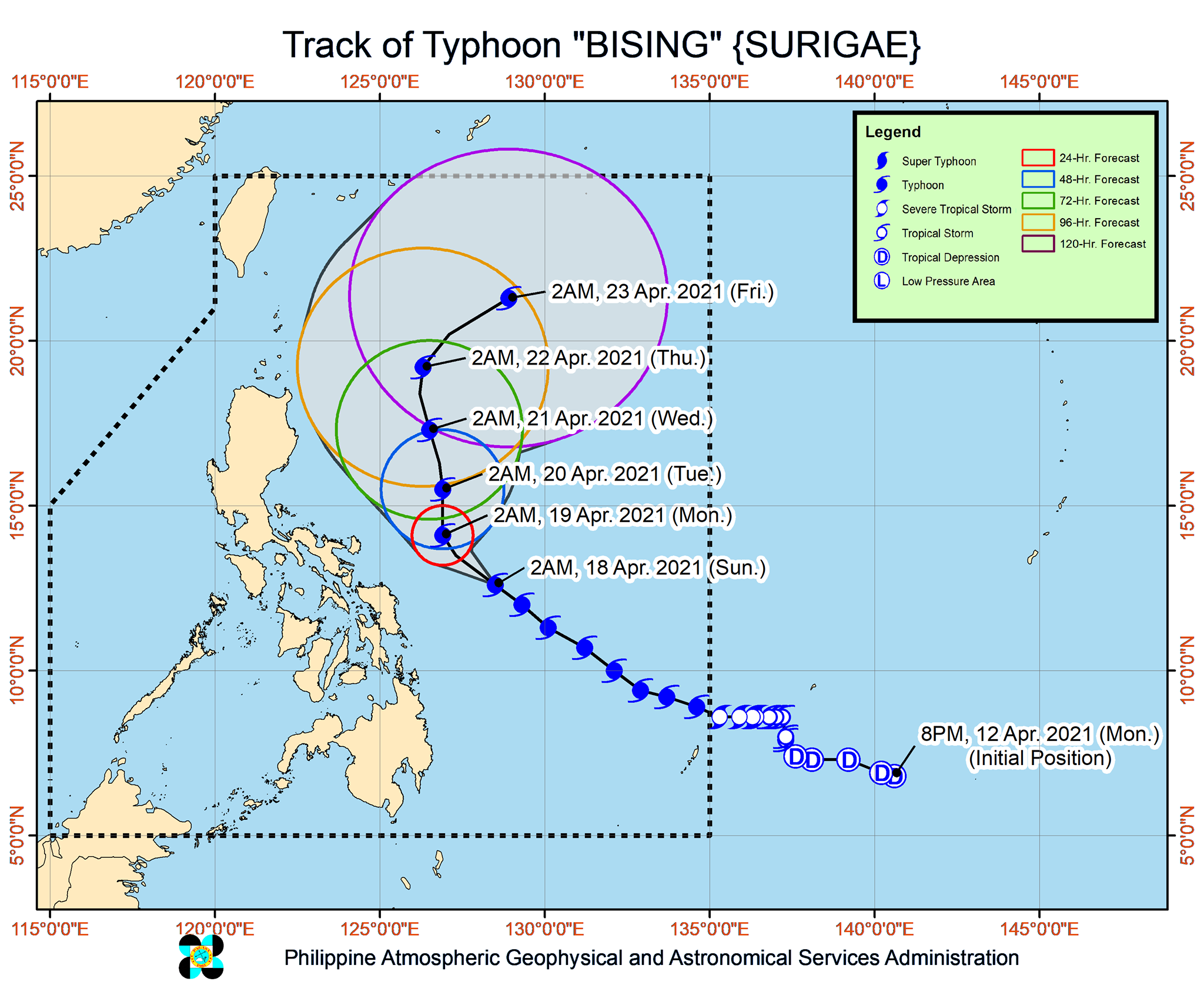
The typhoon is now moving northwest at 15 kilometers per hour (km/h) from the previous 20 km/h.
PAGASA sees Bising continuing its northwest movement east of Bicol on Sunday, adding that it is “likely to slow down considerably and begin turning more northward” on Sunday night or early Monday morning, April 19.
After that, Bising is projected to continue moving north until Tuesday morning, April 20, then turn north northwest while east of Cagayan Valley. Finally, by Wednesday evening, April 21, or early Thursday morning, April 22, the typhoon would turn northeast or east northeast away from Luzon.
But PAGASA said “the possibility of a close approach scenario is not ruled out,” in case Bising shifts west toward land. This could have “potentially significant” effects on the eastern parts of Southern Luzon and the Visayas. (READ: FAST FACTS: Tropical cyclones, rainfall advisories)
So far, Bising continues to have maximum sustained winds of 215 km/h and gustiness of up to 265 km/h.
It is now forecast to maintain its strength on Sunday before gradually weakening in the coming days. PAGASA previously said there was a possibility of Bising reaching super typhoon status, if its maximum sustained winds exceed 220 km/h.
Though Bising is likely to stay over the Philippine Sea, its rainbands are still affecting some areas. The state weather bureau maintained its rainfall forecast for Sunday and Monday, warning of possible floods and landslides.
Sunday, April 18
Moderate to heavy rain, with at times intense rain
- Eastern Visayas
- Bicol
Monday, April 19
Moderate to heavy rain, with at times intense rain
- Bicol
- Northern Samar
- Samar
- Eastern Samar
As of 5 am on Sunday, the following areas are under tropical cyclone wind signals:
Signal No. 2 (winds of 61 to 120 km/h)
- Catanduanes
- Northern Samar
- Eastern Samar
- Samar
Signal No. 1 (winds of 30 to 60 km/h)
- eastern part of Camarines Norte (San Lorenzo Ruiz, San Vicente, Vinzons, Talisay, Daet, Mercedes, Basud)
- Camarines Sur
- Albay
- Sorsogon
- Masbate including Burias and Ticao Islands
- Biliran
- Leyte
- Southern Leyte
- northern part of Cebu (Tabogon, Borbon, San Remigio, Bogo City, Medellin, Daanbantayan), including Bantayan and Camotes Islands
- Dinagat Islands
- Surigao del Norte, including Siargao and Bucas Grande Islands
- northern part of Surigao del Sur (Cagwait, Tago, Bayabas, Tandag City, Lanuza, Cortes, Carmen, Madrid, Cantilan, Carrascal)
PAGASA said tropical cyclone winds that are “at least strong breeze to near gale in strength extend outward up to 440 kilometers” from Bising’s center.
“Destructive typhoon-force winds,” meanwhile, “extend outward up to 110 kilometers” from the center.
Bising and the enhanced northeasterly windflow, added PAGASA, would affect coastal waters in the country in the next 24 hours.
Travel is risky for all types of vessels in the following seaboards:
Very rough to very high seas (waves 4 to 12 meters high)
- northern and eastern seaboards of Eastern Visayas
Rough to very high seas (waves 2.5 to 12 meters high)
- eastern seaboard of Luzon
Rough to very rough seas (waves 3 to 5 meters high)
- eastern seaboard of Caraga
Small vessels would be at risk in these seaboards and “mariners without the proper experience should immediately seek safe harbor”:
Rough to very rough seas (waves 2.5 to 5 meters high)
- northern and western seaboards of Northern Luzon
Rough seas (waves 2.5 to 3.5 meters high)
- eastern seaboard of Davao Region
Small vessels and inexperienced mariners should avoid sailing here:
Moderate to rough seas (waves 1.5 to 3 meters high)
- western seaboard of Central Luzon
- other seaboards of areas under tropical cyclone wind signals
Bising is the Philippines’ second tropical cyclone for 2021. The country usually gets an average of 20 tropical cyclones each year. (READ: LIST: PAGASA’s names for tropical cyclones in 2021)
For the next 6 months, PAGASA estimates the following number of tropical cyclones inside the Philippine Area of Responsibility:
- April – 0 or 1
- May – 0 or 1
- June – 1 or 2
- July – 1 to 3
- August – 2 or 3
- September – 2 or 3
– Rappler.com
Add a comment
How does this make you feel?


There are no comments yet. Add your comment to start the conversation.