SUMMARY
This is AI generated summarization, which may have errors. For context, always refer to the full article.
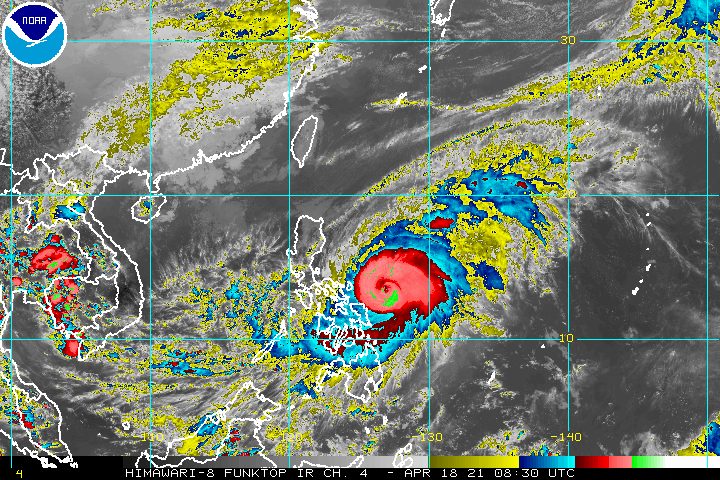
Typhoon Bising (Surigae) slightly weakened and slowed down on Sunday afternoon, April 18. The offshore typhoon, however, is still dumping heavy rain in Eastern Visayas and Bicol.
Bising’s maximum sustained winds are down to 205 kilometers per hour (km/h) from the previous 215 km/h, while its gustiness is at 250 km/h from the previous 265 km/h, said the Philippine Atmospheric, Geophysical, and Astronomical Services Administration (PAGASA) in its 5 pm bulletin.
“Bagama’t bahagyang humina ay nananatili pa rin po itong typhoon category at nananatili pa ring banta sa kaligtasan ng mga kababayan natin, lalong-lalo na dito sa may bandang Bicol region at Eastern Visayas,” PAGASA Senior Weather Specialist Chris Perez said in a briefing.
(Though it has slightly weakened, it remains a typhoon and remains a threat to the safety of our fellow Filipinos, especially those in the Bicol region and Eastern Visayas.)
Bising was last spotted 290 kilometers east of Virac, Catanduanes, moving west northwest at 15 km/h from the previous 20 km/h.
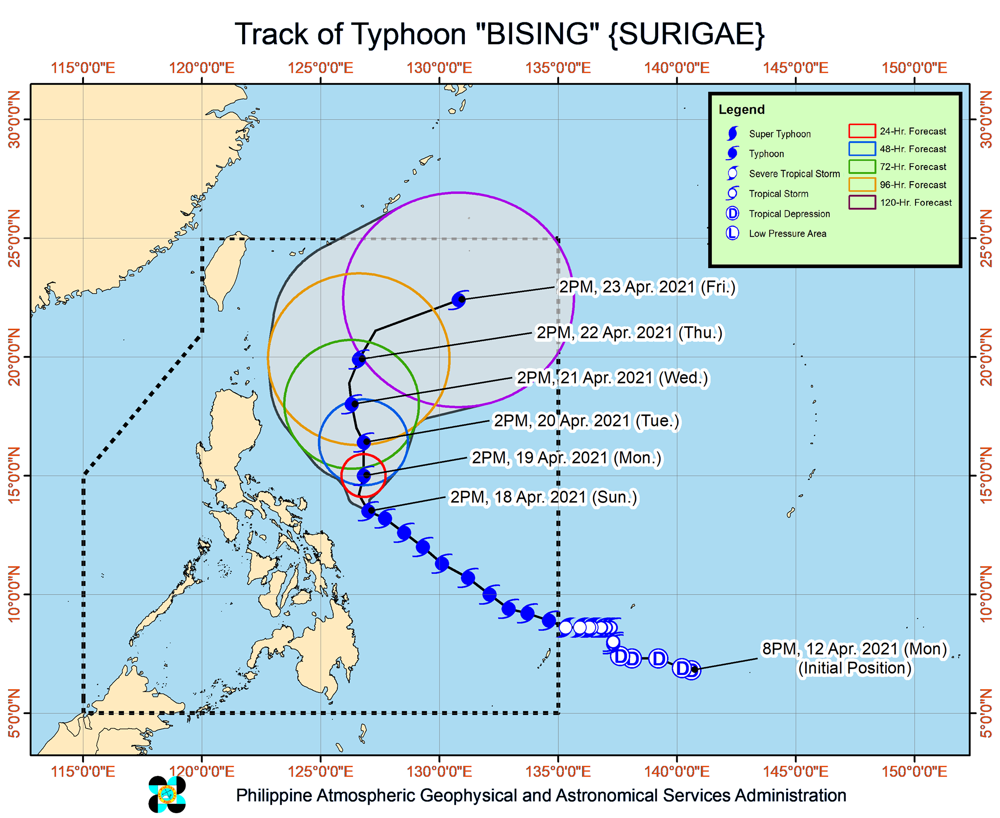
PAGASA expects the typhoon to slowly head northwest until early Monday morning, April 19, while located east of Bicol. Then it is projected to move north until Tuesday afternoon, April 20, before turning north northwest while east of Cagayan Valley.
Finally, by early Wednesday morning, April 21, the typhoon would turn northeast or east northeast away from Luzon. There would be no landfall.
But it is still possible for Bising to go near land in case it shifts westward. (READ: FAST FACTS: Tropical cyclones, rainfall advisories)
PAGASA maintained its rainfall forecast for the rest of Sunday until Monday, warning that floods and landslides remain possible.
Sunday, April 18
Moderate to heavy rain, with at times intense rain
- Eastern Visayas
- Bicol
Monday, April 19
Moderate to heavy rain, with at times intense rain
- Bicol
- Northern Samar
Tropical cyclone wind signals also remain in effect for the following areas as of 5 pm on Sunday:
Signal No. 2 (winds of 61 to 120 km/h)
- Catanduanes
- Northern Samar
- Eastern Samar
- Samar
Signal No. 1 (winds of 30 to 60 km/h)
- eastern part of Camarines Norte (San Lorenzo Ruiz, San Vicente, Vinzons, Talisay, Daet, Mercedes, Basud)
- Camarines Sur
- Albay
- Sorsogon
- Masbate including Burias and Ticao Islands
- Biliran
- Leyte
- Southern Leyte
- northern part of Cebu (Tabogon, Borbon, San Remigio, Bogo City, Medellin, Daanbantayan), including Bantayan and Camotes Islands
- Dinagat Islands
- Siargao and Bucas Grande Islands
PAGASA said tropical cyclone winds that are “at least strong breeze to near gale in strength extend outward up to 440 kilometers” from Bising’s center.
“Destructive typhoon-force winds,” meanwhile, “extend outward up to 110 kilometers” from the center.
Telecommunications giant PLDT and its subsidiary Smart Communications said in a statement on Sunday that they have “prepositioned personnel, backup power supply, and network equipment” ready to be deployed to affected areas if needed.
In the next 24 hours, the country’s coastal waters will continue to feel the impact of Bising and the enhanced northeasterly windflow.
Travel is risky for all types of vessels in the following seaboards:
Very rough to very high seas (waves 4 to 12 meters high)
- northern and eastern seaboards of Eastern Visayas
Rough to very high seas (waves 2.5 to 12 meters high)
- eastern seaboard of Luzon
Rough to very rough seas (waves 3 to 5 meters high)
- eastern seaboard of Caraga
Small vessels would be at risk in these seaboards and “mariners without the proper experience should immediately seek safe harbor”:
Rough to very rough seas (waves 2.5 to 5 meters high)
- northern and western seaboards of Northern Luzon
Rough seas (waves 2.5 to 3.5 meters high)
- eastern seaboard of Davao Region
Small vessels and inexperienced mariners should avoid sailing here:
Moderate to rough seas (waves 1.5 to 3 meters high)
- western seaboard of Central Luzon
- other seaboards of areas under tropical cyclone wind signals
Bising is the Philippines’ second tropical cyclone for 2021. The country usually gets an average of 20 tropical cyclones each year. (READ: LIST: PAGASA’s names for tropical cyclones in 2021)
For the next 6 months, PAGASA estimates the following number of tropical cyclones inside the Philippine Area of Responsibility:
- April – 0 or 1
- May – 0 or 1
- June – 1 or 2
- July – 1 to 3
- August – 2 or 3
- September – 2 or 3
– Rappler.com
Add a comment
How does this make you feel?


There are no comments yet. Add your comment to start the conversation.