SUMMARY
This is AI generated summarization, which may have errors. For context, always refer to the full article.
Signal No. 2 was completely lifted on Wednesday morning, April 21, though Signal No. 1 is still raised in parts of Luzon due to Typhoon Bising (Surigae).
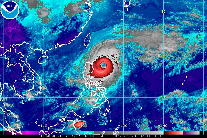
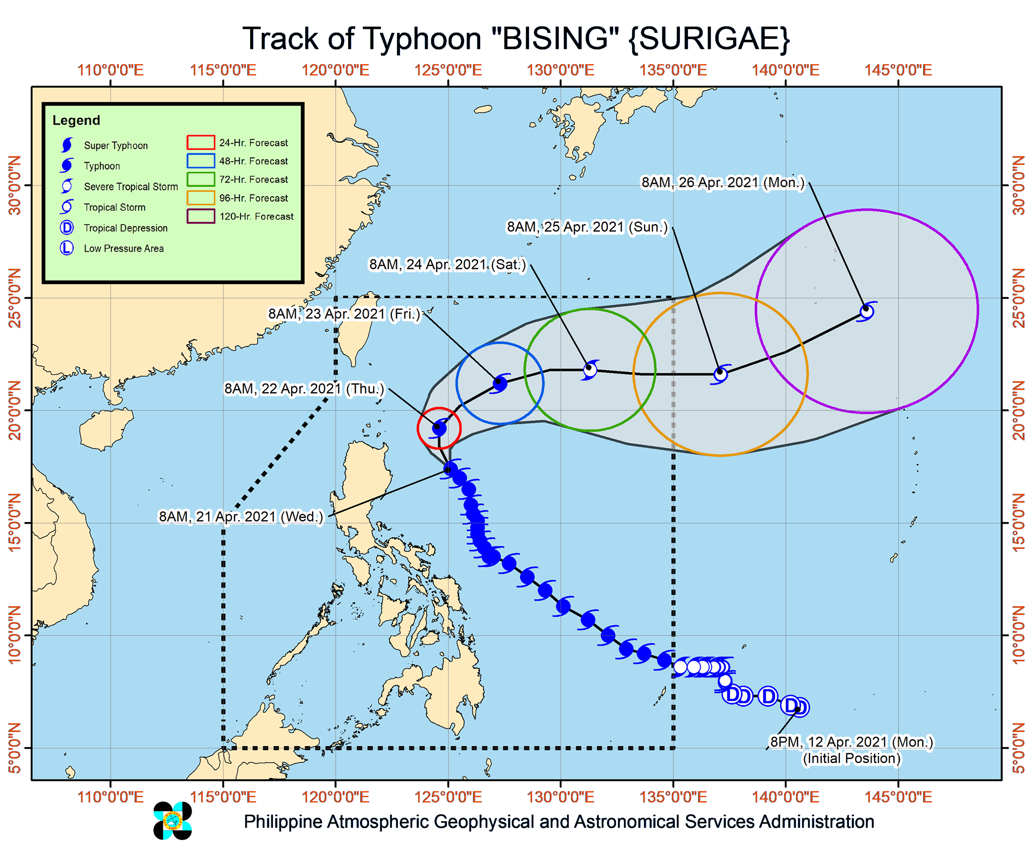
In a bulletin issued 11 am on Wednesday, the Philippine Atmospheric, Geophysical, and Astronomical Services Administration (PAGASA) said Bising was located 360 kilometers east of Tuguegarao City, Cagayan.
The typhoon slowed down, moving northwest at 10 kilometers per hour (km/h) from the previous 15 km/h.
It maintained its strength, with maximum sustained winds of 175 km/h and gustiness of up to 215 km/h. But PAGASA sees Bising getting downgraded to a severe tropical storm by Saturday, April 24, and to a tropical storm by Sunday, April 25. (READ: FAST FACTS: Tropical cyclones, rainfall advisories)
Here are the areas under Signal No. 1 as of 11 am on Wednesday, where winds of 30 to 60 km/h are expected:
- Batanes
- Cagayan including Babuyan Islands
- eastern part of Apayao (Luna, Santa Marcela, Flora, Pudtol)
- eastern part of Kalinga (Pinukpuk, Rizal)
- eastern part of Isabela (Ilagan, San Mariano, Palanan, Divilacan, Maconacon, San Pablo, Cabagan, Tumauini, Santa Maria, Delfin Albano, Santo Tomas, Quezon, Quirino, Gamu, Naguilian, Benito Soliven, Reina Mercedes, Mallig, Burgos, Roxas, Cauayan City, Luna, San Manuel, Cabatuan, Aurora, Dinapigue, San Mateo, Alicia, Angadanan, San Guillermo, Echague, Jones, San Agustin, San Isidro)
- northeastern part of Quirino (Maddela)
- northern part of Aurora (Casiguran, Dilasag)
PAGASA said tropical cyclone winds that are “at least strong breeze to near gale in strength extend outward up to 370 kilometers” from Bising’s center.
“Destructive typhoon-force winds,” meanwhile, “extend outward up to 90 kilometers” from the center.
Coastal and mountainous areas in Northern Luzon which are not under Signal No. 1 may also have strong breeze to near-gale conditions due to the northeasterly wind flow enhanced by Bising.
Though the typhoon did not make landfall, it caused rain in parts of the country the past 4 days, which led to floods and landslides.
The National Disaster Risk Reduction and Management Council said on Wednesday it is validating reports that Bising left at least 3 people dead, 10 injured, and 1 missing.
Meanwhile, PAGASA maintained its outlook for coastal waters, which are still affected by Bising and the enhanced northeasterly wind flow.
Rough to high seas
Travel is risky for all vessels
- northern and eastern seaboards of Luzon (waves 2.5 to 9 meters high)
Rough to very rough seas
Travel is risky for small vessels, while inexperienced mariners “should immediately seek safe harbor”
- western seaboard of Northern Luzon (waves 2.8 to 4.5 meters high)
- northern and eastern seaboards of Northern Samar (waves 2.5 to 4.5 meters high)
Moderate to rough seas
Small vessels and inexperienced mariners should avoid venturing out to sea
- western seaboard of Central Luzon, remaining eastern seaboard of Eastern Visayas, and eastern seaboard of Mindanao (waves 1.5 to 3 meters high)
PAGASA expects Bising to move north or north northwest until Wednesday evening or early Thursday morning, April 22, “when the typhoon will be nearest to the landmass of Northern Luzon.”
Then it would head northeast for the rest of Thursday, and east northeast on Friday, April 23, and Saturday.
Finally, Bising might leave the Philippine Area of Responsibility (PAR) on Saturday evening or Sunday morning.
Bising is the Philippines’ second tropical cyclone for 2021. The country usually gets an average of 20 tropical cyclones each year. (READ: LIST: PAGASA’s names for tropical cyclones in 2021)
For the next 6 months, PAGASA estimates the following number of tropical cyclones inside PAR:
- April – 0 or 1
- May – 0 or 1
- June – 1 or 2
- July – 1 to 3
- August – 2 or 3
- September – 2 or 3
– Rappler.com
Add a comment
How does this make you feel?


There are no comments yet. Add your comment to start the conversation.