SUMMARY
This is AI generated summarization, which may have errors. For context, always refer to the full article.
MANILA, Philippines – Typhoon Chedeng (Guchol) is expected to enhance the southwest monsoon or habagat in the next three days, the Philippines’ weather bureau warned on Thursday evening, June 8.
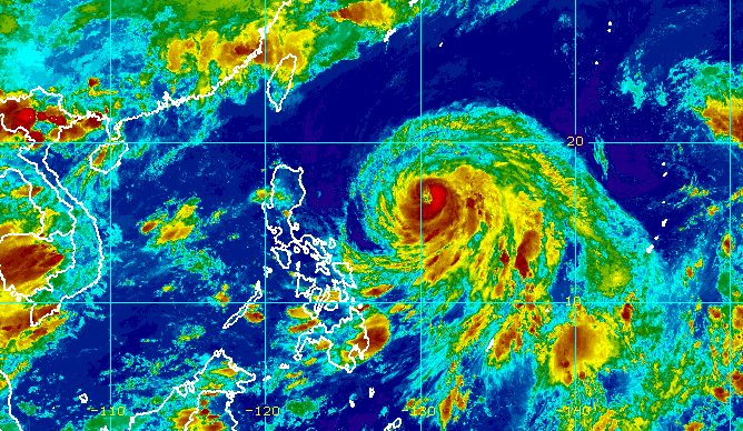
Chedeng was last spotted 915 kilometers east of Central Luzon, moving west northwest at a slightly slower 10 kilometers per hour from the previous 15 km/h.
The typhoon intensified further, with its maximum sustained winds increasing from 120 km/h to 130 km/h. Its gustiness is now up to 160 km/h from the previous 150 km/h.
The Philippine Atmospheric, Geophysical, and Astronomical Services Administration (PAGASA) reiterated in a press briefing past 11 pm on Thursday that Chedeng has no direct effect on the country since it is staying far from land.
The typhoon is not bringing rain and tropical cyclone wind signals are unlikely to be raised. Coastal waters are not affected, too.
But PAGASA said the enhanced southwest monsoon may trigger occasional rain in parts of southwestern Luzon, particularly the following areas:
Saturday, June 10
- Occidental Mindoro, Calamian Islands, and Caluya, Antique
Sunday, June 11
- Occidental Mindoro, northern part of Palawan including Calamian and Cuyo islands, and Antique
Gusts, or sudden and strong winds, are also possible in these areas due to the southwest monsoon:
Friday, June 9
- Visayas, Romblon, Occidental Mindoro, northern part of Palawan including Kalayaan, Calamian, and Cuyo islands, Surigao del Norte, Dinagat Islands, Camiguin
Saturday, June 10
- Visayas, Calabarzon, Mimaropa, Bicol, Camiguin, Dinagat Islands
Sunday, June 11
- Western Visayas, Northern Samar, Mimaropa, Bicol, Calabarzon, Metro Manila, Ilocos Region, Zambales, Bataan, Bulacan, Aurora, Benguet
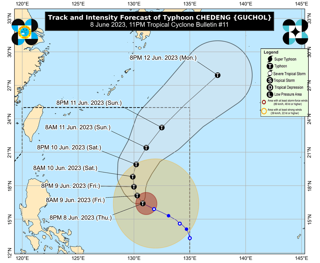
Chedeng is expected to turn northwest on Friday, June 9, and north or north northeast on Saturday, June 10. During this period, the typhoon could reach its peak intensity.
Then Chedeng may speed up north northeast or northeast, before eventually leaving the Philippine Area of Responsibility (PAR) on Sunday evening, June 11, or Monday morning, June 12.
While on its way out of PAR on Sunday, the typhoon may also start weakening, PAGASA said.
Chedeng is the Philippines’ third tropical cyclone for 2023 and the first for June. PAGASA earlier estimated there would be one or two tropical cyclones during the month.
The weather bureau announced the start of the rainy season last Friday, June 2. – Rappler.com
Add a comment
How does this make you feel?


There are no comments yet. Add your comment to start the conversation.