SUMMARY
This is AI generated summarization, which may have errors. For context, always refer to the full article.
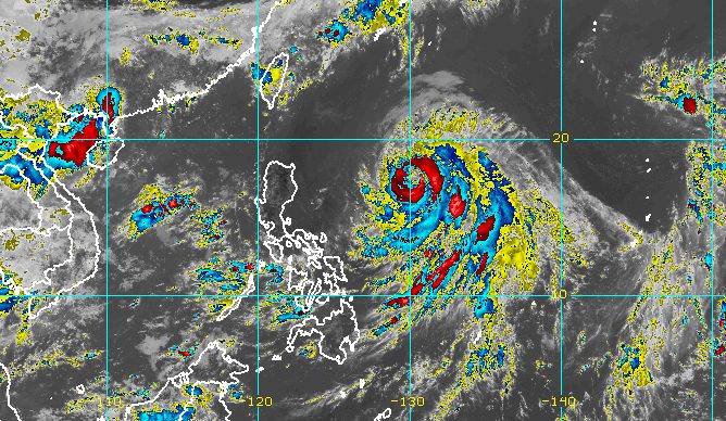
MANILA, Philippines – Typhoon Chedeng (Guchol) maintained its strength while moving over the Philippine Sea on Friday morning, June 9.
The Philippine Atmospheric, Geophysical, and Astronomical Services Administration (PAGASA) said in its 11 am bulletin on Friday that Chedeng was already 920 kilometers east of Northern Luzon.
The typhoon is moving north northwest at 10 kilometers per hour (km/h) and is “approaching the period where it will be closest to the country.” Overall, though, it will remain far from Philippine landmass.
Chedeng still has maximum sustained winds of 130 km/h and gustiness of up to 160 km/h.
Since the typhoon is far from land, it is not causing rain in any part of the country and tropical cyclone wind signals are unlikely to be raised.
But PAGASA said Chedeng may trigger moderate to rough seas in the seaboards of extreme Northern Luzon and the eastern seaboard of mainland Northern Luzon. Waves could be 2 to 3.5 meters high.
PAGASA advised small vessels to take precautionary measures.
The weather bureau also noted that Chedeng could enhance the southwest monsoon or habagat, which may bring occasional rain to parts of southwestern Luzon, particularly the following areas:
Saturday, June 10
- Occidental Mindoro, Calamian Islands, northwestern part of Antique (Caluya)
Sunday, June 11
- Zambales, Bataan, Occidental Mindoro, northern part of Palawan including Calamian and Cuyo islands, Antique
Floods and landslides are possible, warned PAGASA.
The southwest monsoon may also bring gusts, or sudden and strong winds, to these areas:
Friday, June 9
- Visayas, Romblon, Occidental Mindoro, northern part of Palawan including Kalayaan, Calamian, and Cuyo islands, Surigao del Norte, Dinagat Islands, Camiguin
Saturday, June 10
- Visayas, Calabarzon, Mimaropa, Bicol, Camiguin, Dinagat Islands
Sunday, June 11
- Western Visayas, Northern Samar, Mimaropa, Bicol, Calabarzon, Metro Manila, Ilocos Region, Zambales, Bataan, Bulacan, Aurora, Benguet

Chedeng is projected to move northwest for the rest of Friday, before turning north or north northeast on Saturday, June 10.
Then Chedeng may speed up northeast toward the sea south of Japan on Sunday, June 11.
It is expected to leave the Philippine Area of Responsibility on Monday, June 12.
PAGASA also said Chedeng may reach a peak intensity of 140 km/h within 24 to 36 hours. It could start weakening afterwards, but is seen to remain a typhoon.
Chedeng is the Philippines’ third tropical cyclone for 2023 and the first for June. PAGASA earlier estimated there would be one or two tropical cyclones during the month.
The weather bureau announced the start of the rainy season last Friday, June 2. – Rappler.com
Add a comment
How does this make you feel?


There are no comments yet. Add your comment to start the conversation.