SUMMARY
This is AI generated summarization, which may have errors. For context, always refer to the full article.
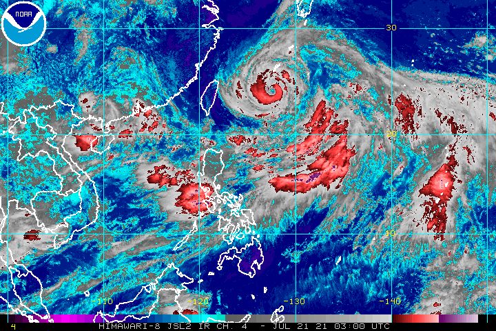
Typhoon Fabian (In-fa) further intensified on Wednesday morning, July 21, as it lingered inside the Philippine Area of Responsibility (PAR).
While Fabian is not expected to make landfall in the country, its growing strength and slow pace are bad news since the typhoon is still enhancing the southwest monsoon or hanging habagat.
Aside from Fabian, also enhancing the southwest monsoon is Cempaka, which has since weakened into a tropical storm while remaining outside PAR. (READ: FAST FACTS: Tropical cyclones, rainfall advisories)
The enhanced southwest monsoon has been causing the rain in parts of the Philippines, mostly in Luzon and Western Visayas, for around four days now.
The Philippine Atmospheric, Geophysical, and Astronomical Services Administration (PAGASA) said in a briefing past 11 am on Wednesday that Fabian now has maximum sustained winds of 150 kilometers per hour and gustiness of up to 185 km/h.
The typhoon previously had maximum sustained winds of 130 km/h and gustiness of up to 160 km/h.
Fabian was located 705 kilometers east northeast of Itbayat, Batanes, slowly moving west.
Cempaka, meanwhile, was estimated at 1,065 kilometers west northwest of extreme Northern Luzon or in the vicinity of Maoming, Guangdong, China.
Due to the southwest monsoon being enhanced by Fabian and Cempaka, monsoon rain will continue on Wednesday. Below is PAGASA’s rainfall forecast as of 11 am.
Moderate to heavy rain, with at times intense rain
- Metro Manila
- Zambales
- Bataan
- Cavite
- Batangas
- Occidental Mindoro
Moderate to heavy rain
- Ilocos Region
- Cordillera Administrative Region
- Batanes
- Babuyan Islands
- Tarlac
- Pampanga
- Bulacan
- northern part of Palawan including Calamian and Kalayaan Islands
PAGASA advised affected areas to stay on alert for flash floods and landslides.
The bad weather on Wednesday prompted the Supreme Court to order early dismissal, effective noon, for the SC, Court of Appeals, Court of Tax Appeals, Sandiganbayan, and all National Capital Judicial Region courts and offices under the Office of the Court Administrator, Presidential Electoral Tribunal, and Judicial and Bar Council.
The Bataan provincial government also suspended classes in all levels for public and private schools on Wednesday.
Meanwhile, PAGASA is not ruling out the possibility of placing Batanes and Babuyan Islands under Signal No. 1, as these areas could experience winds from Fabian. Strong winds extend outwards up to 650 kilometers from the center of the typhoon.
Both Fabian and the enhanced southwest monsoon are making travel risky for small vessels as well, particularly in these seaboards:
Rough to very rough seas (waves 2.5 to 4.5 meters high)
- seaboards of Batanes and Babuyan Islands
- western seaboard of Palawan (including Kalayaan and Calamian Islands) and Occidental Mindoro (including Lubang Islands)
Moderate to rough seas (waves 1.5 to 3 meters high)
- eastern seaboard of Luzon
- rest of northern and western seaboards of Luzon
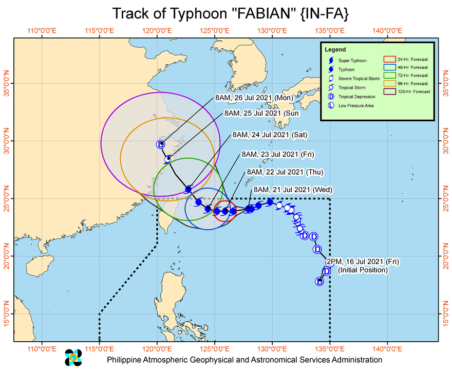
PAGASA expects Fabian to move west until Thursday evening, July 22; west northwest on Friday morning, July 23; then northwest by Friday evening.
On Thursday, the typhoon is seen to reach its peak intensity of 165 km/h – higher than the previous forecast of 155 km/h.
Fabian could pass close to or make landfall in Japan’s Yaeyama, Miyako, and Senkaku Islands on Friday before leaving PAR on Saturday morning, July 24.
Also on Saturday morning, Fabian may move over the coastal waters of northern Taiwan.
Then the typhoon could make landfall in the southeastern part of China by Sunday, July 25, followed by its rapid weakening.
Fabian is the Philippines’ sixth tropical cyclone for 2021 and the second for July.
An average of 20 tropical cyclones form within or enter PAR each year. (READ: LIST: PAGASA’s names for tropical cyclones in 2021)
These are PAGASA’s latest available estimates per month:
2021
- July – 1 to 3
- August – 2 or 3
- September – 2 or 3
- October – 2 or 3
- November – 2 or 3
- December – 1 or 2
2022
- January – 0 or 1
The rainy season has been underway since early June. – Rappler.com
Add a comment
How does this make you feel?


There are no comments yet. Add your comment to start the conversation.