SUMMARY
This is AI generated summarization, which may have errors. For context, always refer to the full article.
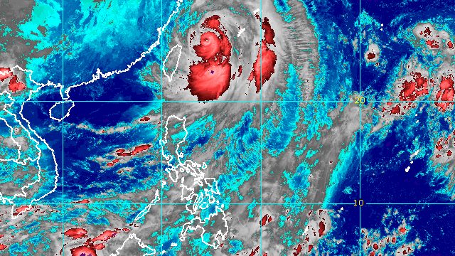
MANILA, Philippines – Typhoon Henry (Hinnamnor) left the Philippine Area of Responsibility (PAR) before dawn on Sunday, September 4, but continues to enhance the southwest monsoon or hanging habagat.
The Philippine Atmospheric, Geophysical, and Astronomical Services Administration (PAGASA) said in its 5 am bulletin on Sunday that Henry was already 590 kilometers north northeast of Itbayat, Batanes, over the East China Sea and outside PAR.
The typhoon is moving north northwest at 15 kilometers per hour (km/h), heading for South Korea where it could make landfall on Tuesday, September 6.
Henry maintained its strength as it left PAR, with maximum sustained winds of 150 km/h and gustiness of up to 185 km/h.
At its peak, Henry was a super typhoon with maximum sustained winds of 195 km/h.
It did not make landfall in the Philippines, but affected the country’s northernmost provinces due to its size.
With Henry’s exit, tropical cyclone wind signals have been lifted. The highest wind signal previously raised was Signal No. 2.
But the typhoon is still enhancing the southwest monsoon. PAGASA said the following areas will have scattered rain showers and thunderstorms on Sunday:
- Metro Manila
- Ilocos Region
- Batanes
- Babuyan Islands
- Abra
- Benguet
- Zambales
- Bataan
- Tarlac
- Pampanga
- Nueva Ecija
- Bulacan
- Cavite
- Batangas
- Occidental Mindoro
Flash floods and landslides are possible during periods of moderate to heavy rain.
The Davao Region and Soccsksargen will have similar weather conditions, but due to the intertropical convergence zone.
In terms of winds, PAGASA said “the enhanced southwest monsoon, its convergence with the typhoon circulation, and the channeling of winds within the Luzon Strait will continue bringing strong winds” to Batanes and Babuyan Islands on Sunday.
Occasional gusts due to the enhanced southwest monsoon may also be felt in these areas:
- Ilocos Region
- Cordillera Administrative Region
- Central Luzon
- Metro Manila
- Calabarzon
- Bicol
- Cagayan
- Isabela
- Nueva Vizcaya
- Quirino
- Occidental Mindoro
- Oriental Mindoro
- Romblon
Meanwhile, a gale warning was still issued at 5 am on Sunday due to Henry, covering these seaboards:
- northern seaboard of Northern Luzon (Batanes, northern coast of Cagayan including Babuyan Islands, and northern coast of Ilocos Norte) – rough to very rough seas, with waves 2.8 to 5 meters high
- eastern seaboard of Northern Luzon (Isabela and eastern coast of Cagayan) – rough to very rough seas, with waves 2.8 to 4.5 meters high
PAGASA advised small vessels not to sail and large vessels to watch out for big waves.

Henry was the Philippines’ eighth tropical cyclone for 2022. On Thursday, September 1, it absorbed the remnant low that used to be Tropical Depression Gardo, the country’s seventh tropical cyclone for the year.
PAGASA expects 7 to 11 tropical cyclones to enter or develop inside PAR from September 2022 to February 2023. Per month, these are the weather bureau’s estimates:
- September 2022 – 2 or 3
- October 2022 – 2 to 4
- November 2022 – 2 or 3
- December 2022 – 1 or 2
- January 2023 – 0 or 1
- February 2023 – 0 or 1
– Rappler.com
Add a comment
How does this make you feel?


There are no comments yet. Add your comment to start the conversation.