SUMMARY
This is AI generated summarization, which may have errors. For context, always refer to the full article.
Jolina (Conson) rapidly strengthened from a severe tropical storm into a typhoon at 8 pm on Monday, September 6, then made landfall in Hernani, Eastern Samar, at 10 pm.
In a bulletin released past 11 pm on Monday, the Philippine Atmospheric, Geophysical, and Astronomical Services Administration (PAGASA) said Jolina was last spotted in the vicinity of Llorente, Eastern Samar.
The typhoon is moving west northwest at 20 kilometers per hour (km/h), slightly faster than its previous speed of 15 km/h.
It already has maximum sustained winds of 120 km/h from the previous 95 km/h and gustiness of up to 165 km/h from the previous 115 km/h.
With Jolina now a typhoon, rainfall and wind forecasts have been updated as well.
In terms of rain, here’s what to expect on Tuesday, September 7:
Heavy to intense rain, with at times torrential rain
- Samar
- Eastern Samar
- Northern Samar
- Sorsogon
Moderate to heavy rain, with at times intense rain
- rest of Eastern Visayas
- rest of Bicol
PAGASA warned that floods and landslides could now be scattered to widespread.
The state weather bureau has also raised Signal No. 3 for the first time due to Jolina. Below is the list of areas covered by tropical cyclone wind signals as of 11 pm on Monday.
Signal No. 3 (destructive typhoon-force winds)
- southern part of Eastern Samar (Guiuan, Mercedes, Salcedo, Hernani, General MacArthur, Quinapondan, Giporlos, Balangiga, Llorente, Balangkayan, Maydolong, Borongan City, Lawaan)
- southern part of Samar (Calbiga, San Sebastian, Hinabangan, Motiong, Jiabong, Catbalogan City, Zumarraga, Daram, Villareal, Talalora, Pinabacdao, Santa Rita, Basey, Marabut, Paranas)
Signal No. 2 (damaging gale-force to storm-force winds)
- Albay
- Sorsogon
- Masbate including Ticao and Burias Islands
- Northern Samar
- rest of Samar
- rest of Eastern Samar
- Biliran
- northern part of Leyte (Calubian, San Isidro, Tabango, Leyte, Capoocan, Kananga, Jaro, Pastrana, Dagami, Tabontabon, Dulag, Tolosa, Julita, Tanauan, Palo, Santa Fe, Alangalang, Carigara, Tunga, Barugo, San Miguel, Babatngon, Tacloban City)
Signal No. 1 (strong winds with occasional gusts)
- southern part of Quezon (Pagbilao, Padre Burgos, Atimonan, Agdangan, Plaridel, Unisan, Gumaca, Pitogo, Macalelon, General Luna, Mulanay, Catanauan, San Francisco, San Andres, San Narciso, Buenavista, Lopez, Guinayangan, Tagkawayan, Calauag, Quezon, Alabat, Perez)
- Camarines Norte
- Camarines Sur
- Catanduanes
- Romblon
- Marinduque
- rest of Leyte
- Southern Leyte
- northern part of Cebu (Borbon, San Remigio, Tabogon, Bogo City, Medellin, Daanbantayan, Santa Fe) including Bantayan and Camotes Islands
- Dinagat Islands
- Siargao and Bucas Grande in Surigao del Norte
PAGASA also warned that on Tuesday, “there is a moderate to high risk of life-threatening coastal inundation” due to storm surges of up to 1 meter in the coastal areas of Eastern Samar.
Jolina will also continue to affect coastal waters on Tuesday.
Rough to very rough seas (waves 2.6 to 4.5 meters high)
Travel risky for small vessels, inexperienced mariners should seek safe harbor
- seaboards of areas under Signal Nos. 2 and 3
Moderate to rough seas (waves 1.2 to 2.8 meters high)
Small vessels must take precautionary measures, inexperienced mariners should avoid navigation
- seaboards of areas under Signal No. 1
- eastern seaboards of Mindanao
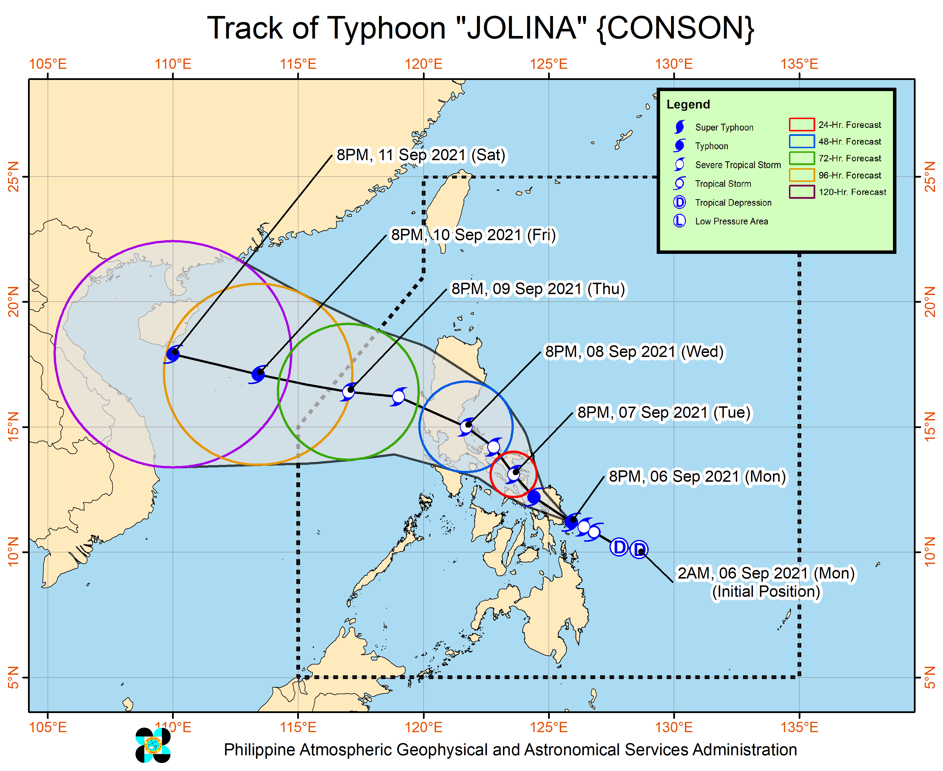
PAGASA expects Jolina to keep moving west northwest or northwest in the next 36 hours, or until around noontime of Wednesday, September 8.
It may cross Samar Island and Bicol before emerging off the northern coast of Camarines Norte. PAGASA noted that Jolina could weaken back into a severe tropical storm due to “prolonged interaction” with the landmass of Samar Island and Bicol.
Then Jolina could turn west northwest on Wednesday evening while crossing the Polillo Islands, and make another landfall in the northern part of Quezon or the southern part of Aurora.
Finally, Jolina could emerge over the West Philippine Sea, west of Central Luzon, by Thursday morning, September 9. At this point, it might intensify again offshore.
Jolina may exit the Philippine Area of Responsibility (PAR) on Thursday evening.
Jolina’s intensification from a low pressure area into a tropical depression all the way to a typhoon happened just on Monday.
- tropical depression – 2 am
- tropical storm – 2 pm
- severe tropical storm – 5 pm
- typhoon – 8 pm
PAGASA Weather Specialist Ariel Rojas explained in a briefing at 12:30 am on Tuesday that favorable atmospheric and oceanic conditions led to the rapid intensification.
Compact tropical cyclones like Jolina, added Rojas, tend to intensify rapidly.
Jolina’s movement has also been erratic, which led to high uncertainty in its forecast track.
Rojas said weather models and observation stations had difficulty capturing Jolina’s movement as well due to its compact nature. (READ: FAST FACTS: Tropical cyclones, rainfall advisories)

Meanwhile, the tropical depression outside PAR which PAGASA has been monitoring was located 1,460 kilometers east of Southern Luzon late Monday evening.
The tropical depression is moving northwest at only 10 km/h, and may enter PAR by Wednesday morning. It would be given the local name Kiko.
It continues to have maximum sustained winds of 55 km/h and gustiness of up to 70 km/h. But Rojas said it is projected to eventually reach typhoon status.
For now, the potential Kiko is unlikely to make landfall in the Philippines, but a tropical cyclone wind signal could be raised for the Batanes area if the weather disturbance goes near the province.
Jolina is the Philippines’ 10th tropical cyclone for 2021 and the first for September.
For the next six months, these are PAGASA’s estimates for the number of tropical cyclones inside PAR:
2021
- September – 2 or 3
- October – 2 or 3
- November – 2 or 3
- December – 1 or 2
2022
- January – 0 or 1
- February – 0 or 1
An average of 20 tropical cyclones form within or enter PAR each year. (READ: LIST: PAGASA’s names for tropical cyclones in 2021) – Rappler.com
Add a comment
How does this make you feel?


There are no comments yet. Add your comment to start the conversation.