SUMMARY
This is AI generated summarization, which may have errors. For context, always refer to the full article.
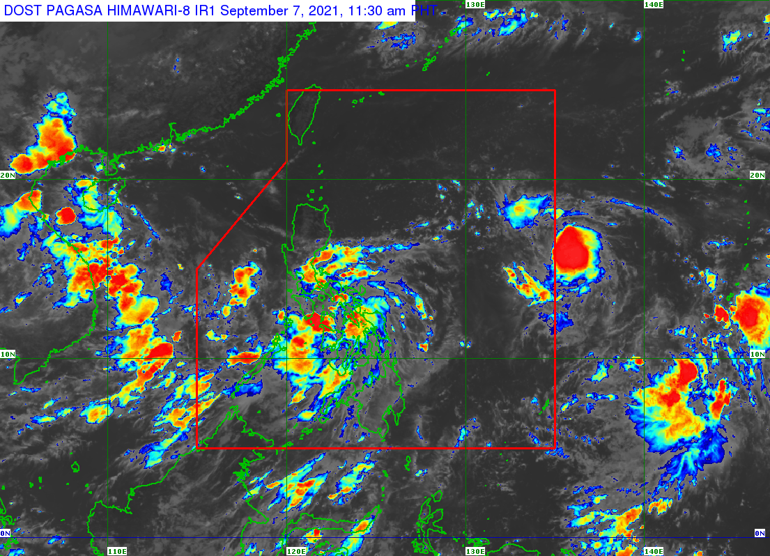
Typhoon Jolina (Conson) made its sixth landfall in Dimasalang, Masbate, at around 10 am on Tuesday, September 7, then started to cross mainland Masbate.
Jolina’s landfalls, so far, were in these areas:
Monday, September 6
- Hernani, Eastern Samar – 10 pm
Tuesday, September 7
- Daram, Samar – 2 am
- Santo Niño, Samar – 3:40 am
- Almagro, Samar – 6:30 am
- Tagapul-an, Samar – 7:50 am
- Dimasalang, Masbate – 10 am
In a briefing past 1 pm on Tuesday, the Philippine Atmospheric, Geophysical, and Astronomical Services Administration (PAGASA) said Jolina was still moving west northwest at 15 kilometers per hour (km/h).
The typhoon maintained its strength, with maximum sustained winds of 120 km/h and gustiness of up to 150 km/h. (READ: FAST FACTS: Tropical cyclones, rainfall advisories)
PAGASA has updated the list of areas in its rainfall forecast for the next 24 hours, still warning of scattered to widespread floods and landslides.
Heavy to intense rain, with at times torrential rain
- Masbate
- Leyte
- Biliran
- Samar
- Northern Samar
- Sorsogon
- Albay
- Catanduanes
- Camarines Norte
- Camarines Sur
- southern part of Quezon
- Romblon
- Marinduque
Moderate to heavy rain, with at times intense rain
- rest of Visayas
- rest of Calabarzon
- Occidental Mindoro
- Oriental Mindoro
In terms of wind, below are the areas where tropical cyclone wind signals are raised as of 11 am on Tuesday.
Signal No. 3 (destructive typhoon-force winds)
- extreme southern part of Quezon (San Francisco, San Narciso, San Andres, Mulanay, Buenavista, Catanauan)
- Masbate including Ticao and Burias Islands
- western part of Albay (Pio Duran, Ligao City, Oas, Libon, Jovellar)
- western part of Sorsogon (Matnog, Bulan, Magallanes, Pilar, Castilla, Donsol)
- northwestern part of Samar (Calbayog City, Tagapul-an, Santo Niño, Almagro)
- extreme western part of Northern Samar (San Antonio, Capul, San
Vicente, San Isidro) - northern part of Biliran (Maripipi)
Signal No. 2 (damaging gale-force to storm-force winds)
- Albay
- Sorsogon
- central and southern parts of Quezon (Real, Mauban, Sampaloc, Lucban, Tayabas City, Sariaya, Candelaria, Dolores, Tiaong, San Antonio, Lucena City, Pagbilao, Atimonan, Padre Burgos, Agdangan, Unisan, Plaridel, Gumaca, Pitogo, Macalelon, General Luna, Lopez, Guinayangan, Calauag, Quezon, Alabat, Perez, Tagkawayan)
- southeastern part of Batangas (Padre Garcia, Rosario, San Juan, Lobo, Taysan)
- western part of Camarines Norte (Capalonga, Jose Panganiban, Labo, San Vicente, San Lorenzo Ruiz, Santa Elena)
- western and southern parts of Camarines Sur (Del Gallego, Lupi, Ragay, Libmanan, Sipocot, Cabusao, Pasacao, Pamplona, Gainza, Camaligan, Canaman, Magarao, Bombon, Naga City, Pili, Ocampo, Iriga City, Sagñay, Buhi, Milaor, San Fernando, Minalabac, Bula, Nabua, Baao, Balatan, Bato, Calabanga)
- Marinduque
- rest of Albay
- rest of Sorsogon
- eastern part of Romblon (Cajidiocan, Magdiwang, San Fernando, Romblon, Corcuera, Banton, Concepcion)
- western part of Northern Samar (Lavezares, Allen, Victoria, Rosario, San Jose, Bobon, Catarman, Lope de Vega, Mondragon, San Roque, Pambujan, Silvino Lobos, Biri)
- northern part of Samar (Santa Margarita, Gandara, San Jose de Buan, Matuguinao, San Jorge, Pagsanghan, Tarangnan, Catbalogan City, Jiabong, Motiong, Paranas, Hinabangan, San Sebastian, Calbiga, Pinabacdao, Villareal, Santa Rita, Talalora, Daram, Zumarraga)
- Leyte
- rest of Biliran
Signal No. 1 (strong winds with occasional gusts)
- Nueva Ecija
- southeastern part of Nueva Vizcaya (Alfonso Castañeda)
- southern part of Aurora (Dingalan, San Luis, Maria Aurora, Baler)
- southern part of Zambales (Masinloc, Palauig, Iba, Botolan, Cabangan, San Felipe, San Marcelino, San Narciso, San Antonio, Castillejos, Subic, Olongapo City)
- Bataan
- Tarlac
- Pampanga
- Bulacan
- Metro Manila
- Rizal
- Laguna
- Cavite
- rest of Batangas
- rest of Romblon
- Oriental Mindoro
- northern part of Occidental Mindoro (Abra de Ilog, Paluan, Mamburao, Santa Cruz, Sablayan, Lubang Islands)
- rest of Quezon
- rest of Camarines Norte
- rest of Camarines Sur
- Eastern Samar
- rest of Samar
- rest of Northern Samar
- northern part of Cebu (Daanbantayan, Medellin, Santa Fe, Bantayan Islands, Bogo City, San Remigio, Tabogon, Borbon, Tabuelan, Sogod, Tuburan, Catmon, Carmen, Danao City, Asturias, Compostela, Camotes Islands, Liloan, Consolacion, Cebu City, Balamban, Mandaue City)
- northern part of Negros Occidental (Cadiz City, Manapla, Enrique B. Magalona, Victorias City, Sagay City, Escalante City, Toboso, Calatrava, Silay City)
- northern part of Iloilo (Carles, Estancia, Balasan, Batad, San Dionisio, Concepcion, Sara, Ajuy, Lemery, San Rafael, Barotac Viejo, Passi City, Bingawan)
- Capiz
- Aklan
PAGASA maintained its storm surge warning for the following provinces, saying that storm surges 0.5 to 1 meter high may affect coastal communities in the next 24 hours:
- Biliran
- Sorsogon
- Samar
- Masbate
Storm surges would “pose a threat to life and property,” warned the state weather bureau.
“In addition, coastal areas of localities under [tropical cyclone wind signals], especially those at No. 2 and No. 3, may experience coastal flooding due to hazardous surf conditions,” PAGASA said.
Coastal waters will continue to be dangerous for vessels due to the typhoon.
Rough to very rough seas (waves 2.5 to 5 meters high)
Travel risky for all vessels, inexperienced mariners should seek safe harbor
- seaboards of areas under Signal Nos. 2 and 3
Moderate to rough seas (waves 1.2 to 2.8 meters high)
Small vessels must take precautionary measures, inexperienced mariners should avoid navigation
- seaboards of areas under Signal No. 1
- remaining seaboards of Visayas
- northern and eastern seaboards of Mindanao
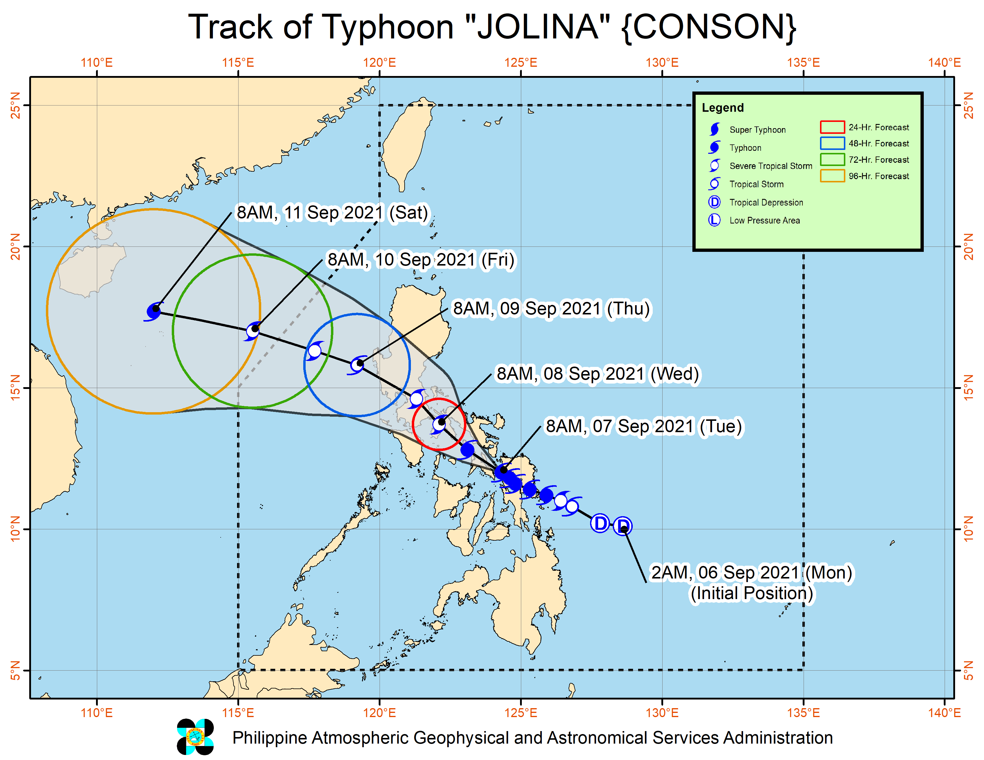
PAGASA expects Jolina to continue moving west northwest over Masbate and the Ragay Gulf, before again making landfall in the southeastern part of Quezon on Tuesday evening or early Wednesday morning, September 8.
Afterwards, Jolina may emerge over Lopez Bay, then make another landfall in the northern part of Quezon.
It will cross Central Luzon for the rest of Wednesday until Thursday morning, September 9, around east and north of Metro Manila. During this time, it may weaken into a tropical storm.
Finally, Jolina could emerge over the West Philippine Sea before noon on Thursday. It may regain strength beginning Thursday afternoon as it heads for the southern China-northern Vietnam area.
It is likely to leave the Philippine Area of Responsibility (PAR) on Friday morning, September 10.
Meanwhile, another tropical cyclone poised to enter PAR by Wednesday morning is still being monitored. PAGASA is expected to give an update on it in the next bulletins.

Jolina is the Philippines’ 10th tropical cyclone for 2021 and the first for September.
For the next six months, these are PAGASA’s estimates for the number of tropical cyclones inside PAR:
2021
- September – 2 or 3
- October – 2 or 3
- November – 2 or 3
- December – 1 or 2
2022
- January – 0 or 1
- February – 0 or 1
An average of 20 tropical cyclones form within or enter PAR each year. (READ: LIST: PAGASA’s names for tropical cyclones in 2021) – Rappler.com
Add a comment
How does this make you feel?


There are no comments yet. Add your comment to start the conversation.