SUMMARY
This is AI generated summarization, which may have errors. For context, always refer to the full article.
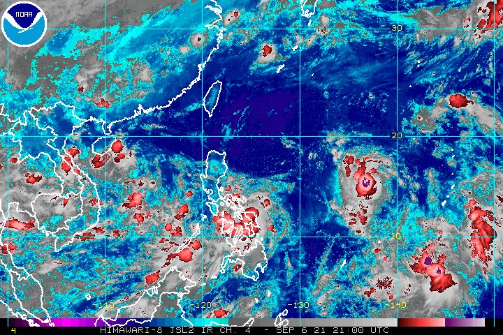
After first making landfall in Eastern Samar late Monday evening, September 6, Typhoon Jolina (Conson) was moving over the adjacent province of Samar in the early hours of Tuesday, September 7.
The Philippine Atmospheric, Geophysical, and Astronomical Services Administration (PAGASA) said in its 5 am bulletin that Jolina had emerged over the Samar Sea and was already crossing the island municipalities of Samar province. Specifically at 4 am, it was over the coastal waters of Santo Niño, Samar.
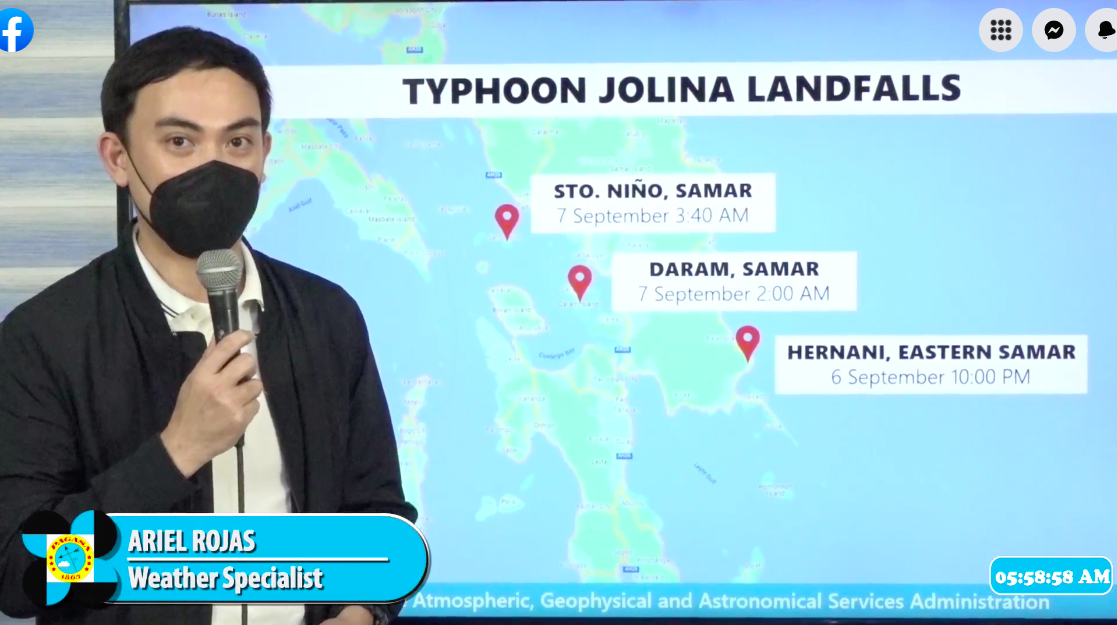
Jolina has now made landfall at least thrice:
- Hernani, Eastern Samar – 10 pm, Monday, September 6
- Daram, Samar – 2 am, Tuesday, September 7
- Santo Niño, Samar – 3:40 am, Tuesday, September 7
The typhoon continues to move west northwest at 20 kilometers per hour (km/h).
It maintained its strength, with maximum sustained winds of 120 km/h, while its gustiness is up to 180 km/h.
PAGASA provided an updated rainfall forecast for Tuesday, also reiterating that scattered to widespread flooding and rain-induced landslides are possible.
Heavy to intense rain, with at times torrential rain
- Eastern Visayas
- Sorsogon
- Masbate
Moderate to heavy rain, with at times intense rain
- rest of Visayas
- rest of Bicol
- southern part of Quezon
- Romblon
- Marinduque
There are no more areas in Mindanao under a tropical cyclone wind signal as of 5 am on Tuesday, but many areas in Luzon and the Visayas are under Signal Nos. 1 to 3.
Signal No. 3 (destructive typhoon-force winds)
- eastern part of Masbate (Pio V. Corpuz, Palanas, Cataingan, Placer, Dimasalang, Uson, Cawayan, Esperanza, Mobo) including Ticao Island
- extreme western part of Northern Samar (San Vicente, Capul, San Antonio, San Isidro)
- northern part of Biliran (Kawayan, Culaba, Caibiran, Maripipi, Almeria)
- northern and central parts of Samar (Catbalogan City, Tarangnan, Jiabong, Motiong, Paranas, Calbiga, Pinabacdao, Villareal, Talalora, Daram, Zumarraga, San Sebastian, Hinabangan, Pagsanghan, Santo Niño, Tagapul-an, Almagro, Santa Margarita, Gandara, San Jorge, Calbayog City)
Signal No. 2 (damaging gale-force to storm-force winds)
- Albay
- Sorsogon
- rest of Masbate including Burias Island
- western and southern parts of Camarines Sur (Del Gallego, Lupi, Ragay, Libmanan, Sipocot, Cabusao, Pasacao, Pamplona, Gainza, Camaligan, Canaman, Magarao, Bombon, Naga City, Pili, Ocampo, Iriga City, Sagñay, Buhi, Milaor, San Fernando, Minalabac, Bula, Nabua, Baao, Balatan, Bato, Calabanga)
- eastern part of Marinduque (Torrijos, Santa Cruz)
- southeastern part of Quezon (Tagkawayan, Guinayangan, Buenavista, Mulanay, San Narciso, San Francisco, San Andres, Catanauan, Calauag, General Luna, Lopez, Macalelon)
- eastern part of Romblon (San Fernando, Magdiwang, Cajidiocan, Romblon, Banton, Corcuera)
- rest of Biliran
- western part of Northern Samar (Silvino Lobos, Lope de Vega, Catarman, Bobon, San Jose, Rosario, Lavezares, Biri, Allen, Victoria, Mondragon)
- rest of Samar
- central and southern parts of Eastern Samar (Can-avid, Taft, Sulat, San Julian, Borongan City, Maydolong, Balangkayan, Llorente, General MacArthur, Quinapondan, Hernani, Salcedo, Mercedes, Guiuan, Balangiga, Lawaan, Maslog, Dolores, Giporlos)
- northern part of Leyte (Calubian, San Isidro, Tabango, Leyte, Villaba, Matag-ob, Ormoc City, Kananga, Carigara, Jaro, Dagami, Julita, Tabontabon, Tolosa, Tanauan, Palo, Pastrana, Santa Fe, Tacloban City, Barugo, San Miguel, Alangalang, Dulag, Tunga, Babatngon, Capoocan)
Signal No. 1 (strong winds with occasional gusts)
- Catanduanes
- rest of Camarines Sur
- Camarines Norte
- rest of Quezon including Polillo Islands
- Laguna
- eastern part of Batangas (Santo Tomas, Lipa City, San Jose, Batangas City, Ibaan, Rosario, Padre Garcia, San Juan, Taysan, Lobo, Tanauan City, Malvar, Balete, Mataasnakahoy, Cuenca, San Pascual)
- rest of Marinduque
- rest of Romblon
- northern and central parts of Oriental Mindoro (Calapan City, Naujan, Victoria, Socorro, Pola, Pinamalayan, Gloria, Bansud, Bongabong, Roxas, Baco, San Teodoro, Puerto Galera)
- rest of Northern Samar
- rest of Eastern Samar
- rest of Leyte
- Southern Leyte
- northern part of Cebu (Carmen, Tuburan, Catmon, Sogod, Tabuelan, Borbon, Tabogon, San Remigio, Bogo City, Medellin, Daanbantayan) including Camotes and Bantayan Islands
- northeastern part of Iloilo (Concepcion, Sara, San Dionisio, Batad, Estancia, Carles, Balasan)
- extreme northern part of Capiz (Pilar, Panay, Roxas City)
PAGASA also warned that the following areas face “the threat of coastal inundation” on Tuesday as there may be storm surges 0.5 to 1 meter high, threatening life and property:
- Eastern Samar
- Samar
- Masbate
“In addition, coastal areas of localities under [tropical cyclone wind signals], especially those at No. 2 and No. 3, may experience coastal flooding due to hazardous surf conditions,” the state weather bureau said.
Jolina also continues to affect coastal waters on Tuesday.
Rough to very rough seas (waves 2.5 to 5 meters high)
Travel risky for small vessels, inexperienced mariners should seek safe harbor
- seaboards of areas under Signal Nos. 2 and 3
Moderate to rough seas (waves 1.2 to 2.8 meters high)
Small vessels must take precautionary measures, inexperienced mariners should avoid navigation
- seaboards of areas under Signal No. 1
- remaining seaboards of Visayas
- northern and eastern seaboards of Mindanao
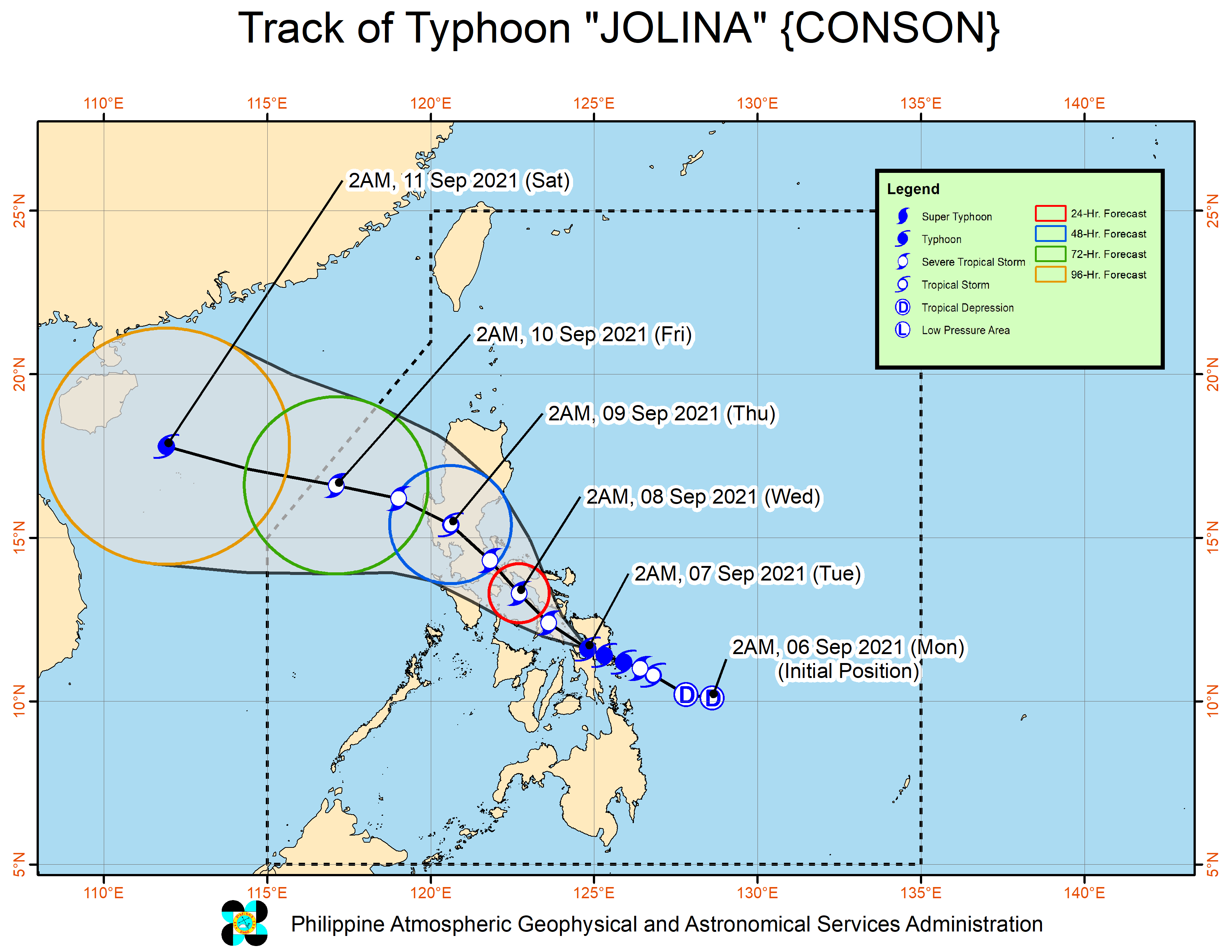
After crossing the island municipalities of Samar, Jolina may pass over or close to the northern coast of Biliran and then make landfall in Masbate, either in the mainland or in Ticao Island, within the next 12 hours. PAGASA said the typhoon may weaken into a severe tropical storm during this period.
Beyond that period, Jolina could head toward Burias Island and the Ragay Gulf, before making another landfall in the southeastern part of Quezon on Tuesday evening or early Wednesday morning, September 8. It could further weaken, too.
And then, by Wednesday afternoon, Jolina may briefly emerge over Lamon Bay before making landfall in the northern part of Quezon.
For the rest of Wednesday until Thursday morning, September 9, Jolina is seen to cross Central Luzon, “roughly to the east and north of Metro Manila,” PAGASA said. While crossing Luzon’s landmass, it may weaken eventually into a tropical storm.
Finally, Jolina could emerge over the West Philippine Sea before noon on Thursday. It may regain strength beginning Thursday afternoon as it heads for the southern China-northern Vietnam area.
It is likely to leave the Philippine Area of Responsibility (PAR) on Friday morning, September 10.
Meanwhile, the tropical depression outside PAR was already 1,685 kilometers east of Central Luzon before dawn on Tuesday.
It is moving northwest at 20 km/h and could enter PAR on Wednesday morning. It would be given the local name Kiko.
The tropical depression still has maximum sustained winds of 55 km/h and gustiness of up to 70 km/h. But since it remains over water, it is expected to intensify and may eventually become a typhoon.
PAGASA said the chances of landfall are slim, but a tropical cyclone wind signal may be raised for Batanes if the potential Kiko goes near the province. (READ: FAST FACTS: Tropical cyclones, rainfall advisories)
Jolina is the Philippines’ 10th tropical cyclone for 2021 and the first for September.
For the next six months, these are PAGASA’s estimates for the number of tropical cyclones inside PAR:
2021
- September – 2 or 3
- October – 2 or 3
- November – 2 or 3
- December – 1 or 2
2022
- January – 0 or 1
- February – 0 or 1
An average of 20 tropical cyclones form within or enter PAR each year. (READ: LIST: PAGASA’s names for tropical cyclones in 2021) – Rappler.com
Add a comment
How does this make you feel?


There are no comments yet. Add your comment to start the conversation.