SUMMARY
This is AI generated summarization, which may have errors. For context, always refer to the full article.
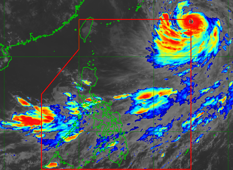
MANILA, Philippines – Typhoon Nanmadol entered the Philippine Area of Responsibility (PAR) at 5:40 pm on Friday, September 16, becoming the country’s 10th tropical cyclone for 2022.
It was given the local name Josie.
The Philippine Atmospheric, Geophysical, and Astronomical Services Administration (PAGASA) earlier said Josie will remain far from the country’s landmass.
It will not directly affect weather in the country, and may already exit PAR on Friday evening or early Saturday morning, September 17.
As of 3 pm on Friday, Josie was over 1,400 kilometers east northeast of extreme Northern Luzon, moving northwest at 10 kilometers per hour (km/h).
The typhoon continuously intensified on Friday, and by mid-afternoon, it already had maximum sustained winds of 175 km/h and gustiness of up to 215 km/h. Before dawn, its maximum sustained winds were at 140 km/h, with gustiness of up to 170 km/h.
PAGASA said on Friday morning that it was expecting Josie to become a super typhoon within 24 hours. A super typhoon has maximum sustained winds of 185 km/h or above.
While Josie will have no direct effect on the Philippines, it is enhancing the southwest monsoon or hanging habagat.
PAGASA said the southwest monsoon will continue bringing scattered rain showers and thunderstorms to these areas:
- Western Visayas
- Palawan
- Occidental Mindoro
- Oriental Mindoro
Flash floods and landslides are possible during periods of moderate to heavy rain.
Gusty conditions may also be felt in these areas due to the southwest monsoon:
- Mimaropa
- Bicol
- Visayas
- northern and western parts of Mindanao
– Rappler.com
Add a comment
How does this make you feel?


There are no comments yet. Add your comment to start the conversation.