SUMMARY
This is AI generated summarization, which may have errors. For context, always refer to the full article.
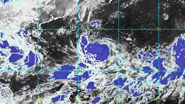
MANILA, Philippines – Typhoon Karding (Noru) continued to rapidly intensify over the Philippine Sea late Saturday evening, September 24, a trend that is expected to persist in the coming hours.
Karding’s maximum sustained winds increased from 120 kilometers per hour to 130 km/h, said the Philippine Atmospheric, Geophysical, and Astronomical Services Administration (PAGASA) in its 11 pm bulletin on Saturday. The typhoon’s gustiness is now up to 160 km/h from the previous 150 km/h.
PAGASA now expects Karding to make landfall at or near a peak intensity of 150 to 155 km/h, referring to maximum sustained winds.
The typhoon was last spotted 430 kilometers east of Baler, Aurora, moving west southwest at a slightly slower 15 km/h from the previous 20 km/h.
It remains on course to make landfall in the southern part of Aurora or the northern part of Quezon on Sunday afternoon or early evening, September 25.
Then it is expected to cross Central Luzon before emerging over the West Philippine Sea late Sunday evening or early Monday morning, September 26. Karding may slightly weaken over land, but it is likely to remain a typhoon.
PAGASA warned that rain from Karding may cause scattered to widespread floods and landslides. Below is the weather bureau’s updated rainfall forecast as of 11 pm on Saturday.
Saturday evening, September 24, to Sunday morning, September 25
Moderate to heavy rain
- mainland Cagayan
- Isabela
Light to moderate rain, with at times heavy rain
- Babuyan Islands
- Aurora
- northern part of Quezon including Polillo Islands
- Catanduanes
- Camarines Norte
- Camarines Sur
Sunday morning to evening, September 25
Heavy to intense rain, with at times torrential rain
- Metro Manila
- Zambales
- Tarlac
- Pampanga
- Nueva Ecija
- Bulacan
- southern part of Aurora
- Rizal
- northern part of Quezon including Polillo Islands
Moderate to heavy rain, with at times intense rain
- rest of Cagayan Valley
- Cordillera Administrative Region
- northern part of Aurora
- Bataan
- Cavite
- Laguna
- central part of Quezon
Light to moderate rain, with at times heavy rain
- Batangas
- Camarines Norte
- Catanduanes
Sunday evening, September 25, to Monday morning, September 26
Heavy to intense rain, with at times torrential rain
- Zambales
- Bataan
- Pampanga
- Bulacan
Moderate to heavy rain, with at times intense rain
- Metro Manila
- Quirino
- rest of Central Luzon
- Cavite
Light to moderate rain, with at times heavy rain
- Mountain Province
- Ifugao
- Benguet
- rest of Calabarzon
PAGASA added that the southwest monsoon or hanging habagat, enhanced by Karding, may trigger occasional rain in the Visayas and the rest of Southern Luzon, especially in their western sections.
The list of areas under tropical cyclone wind signals was updated at 11 pm, too.
Signal No. 3
Storm-force winds (89 to 117 km/h), moderate to significant threat to life and property
- Polillo Islands
- northern part of Camarines Norte (Vinzons, Paracale, Jose Panganiban, Capalonga)
Signal No. 2
Gale-force winds (62 to 88 km/h), minor to moderate threat to life and property
- southern part of Isabela (Dinapigue, San Guillermo, Echague, San Agustin, Jones)
- Quirino
- central and southeastern parts of Nueva Vizcaya (Alfonso Castañeda, Dupax del Sur, Aritao, Santa Fe, Bambang, Dupax del Norte, Kasibu, Quezon, Bayombong, Diadi)
- eastern part of Pangasinan (Mangatarem, Basista, Urbiztondo, Malasiqui, Manaoag, Pozorrubio, Sison, Bayambang, Bautista, Alcala, Santo Tomas, Villasis, Urdaneta City, Laoac, Binalonan, Asingan, Rosales, Santa Maria, Balungao, Umingan, San Quintin, Tayug, Natividad, San Manuel, San Nicolas)
- Bataan
- Tarlac
- Pampanga
- Bulacan
- Nueva Ecija
- Aurora
- Metro Manila
- Cavite
- eastern part of Batangas (Talisay, Tanauan City, Santo Tomas, Malvar)
- Laguna
- Rizal
- northern and central parts of Quezon (General Nakar, Infanta, Real, Mauban, Calauag, Perez, Alabat, Quezon, Tagkawayan, Guinayangan, Sampaloc, Lucban, Tayabas City, Lucena City, Pagbilao, Padre Burgos, Atimonan, Agdangan, Unisan, Plaridel, Gumaca, Lopez, Pitogo, Dolores, Candelaria, Sariaya, Tiaong, Macalelon, General Luna, Catanauan, Buenavista)
- rest of Camarines Norte
- northern part of Camarines Sur (Del Gallego, Ragay, Lupi, Sipocot, Libmanan, Pamplona, Pasacao, San Fernando, Pili, Minalabac, Ocampo, Tigaon, Cabusao, Magarao, Gainza, Canaman, Camaligan, Milaor, Naga City, Bombon, Calabanga, Tinambac, Siruma, Goa, Lagonoy, San Jose, Garchitorena, Presentacion, Caramoan, Sagñay)
- Catanduanes
Signal No. 1
Strong winds (39 to 61 km/h), minimal to minor threat to life and property
- southern part of Cagayan (Tuao, Solana, Enrile, Tuguegarao City, Iguig, Peñablanca)
- rest of Isabela
- rest of Nueva Vizcaya
- southern part of Apayao (Conner)
- Kalinga
- Abra
- Mountain Province
- Ifugao
- Benguet
- southern part of Ilocos Norte (Nueva Era, Badoc, Pinili, Banna, Batac City, Currimao, Paoay, Marcos)
- Ilocos Sur
- La Union
- rest of Pangasinan
- Zambales
- rest of Batangas
- rest of Quezon
- northern part of Occidental Mindoro (Abra de Ilog, Paluan, Mamburao, Santa Cruz) including Lubang Islands
- northern part of Oriental Mindoro (Puerto Galera, San Teodoro, Baco, Calapan City, Naujan, Victoria, Pola)
- Marinduque
- rest of Camarines Sur
- Albay
- northern part of Sorsogon (Donsol, Pilar, Castilla, Sorsogon City, Prieto Diaz, Gubat, Magallanes, Juban, Casiguran)
- Burias Island
The highest possible wind signal due to Karding is Signal No. 4.
PAGASA also issued a new gale warning at 11 pm, covering the following seaboards:
- eastern seaboards of Central Luzon and Southern Luzon (Aurora, Quezon including Polillo Islands, Camarines Norte, Camarines Sur, Catanduanes) – very rough to high seas, waves 4.1 to 7 meters high, risky for all vessels
- eastern seaboard of Northern Luzon (Cagayan, Isabela) – rough to very rough seas, waves 2.8 to 4.5 meters high, fishing boats should not sail
In the northern and western seaboards of Northern Luzon, seas are moderate to rough, with waves 1.5 to 3.5 meters high. Conditions may be risky for small vessels.
The weather bureau also warned that the combined effects of storm surges and high waves breaking along the coast may cause flooding in the coastal areas of the following provinces:
- Aurora
- Quezon (east coast, including Polillo Islands)
- Camarines Norte
Karding could exit the Philippine Area of Responsibility (PAR) on Monday.

Karding is the Philippines’ 11th tropical cyclone for 2022.
It is also the third tropical cyclone for September, after Typhoon Inday (Muifa) and Super Typhoon Josie (Nanmadol). Inday and Josie did not make landfall in the country.
PAGASA expects 7 to 11 tropical cyclones to enter or develop inside PAR from September 2022 to February 2023. Per month, these are the weather bureau’s estimates:
- September 2022 – 2 or 3
- October 2022 – 2 to 4
- November 2022 – 2 or 3
- December 2022 – 1 or 2
- January 2023 – 0 or 1
- February 2023 – 0 or 1
– Rappler.com
Add a comment
How does this make you feel?


There are no comments yet. Add your comment to start the conversation.