SUMMARY
This is AI generated summarization, which may have errors. For context, always refer to the full article.
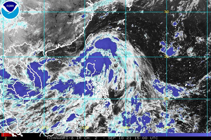
Typhoon Kiko (Chanthu) maintained its strength late Friday evening, September 10, while heading toward Babuyan Island, which is under Signal No. 4.
The Philippine Atmospheric, Geophysical, and Astronomical Services Administration (PAGASA) said in a briefing past 11 pm on Friday that Kiko was already 135 kilometers east southeast of Calayan, Cagayan.
The typhoon was moving northwest at a slightly faster 20 kilometers per hour from the previous 15 km/h.
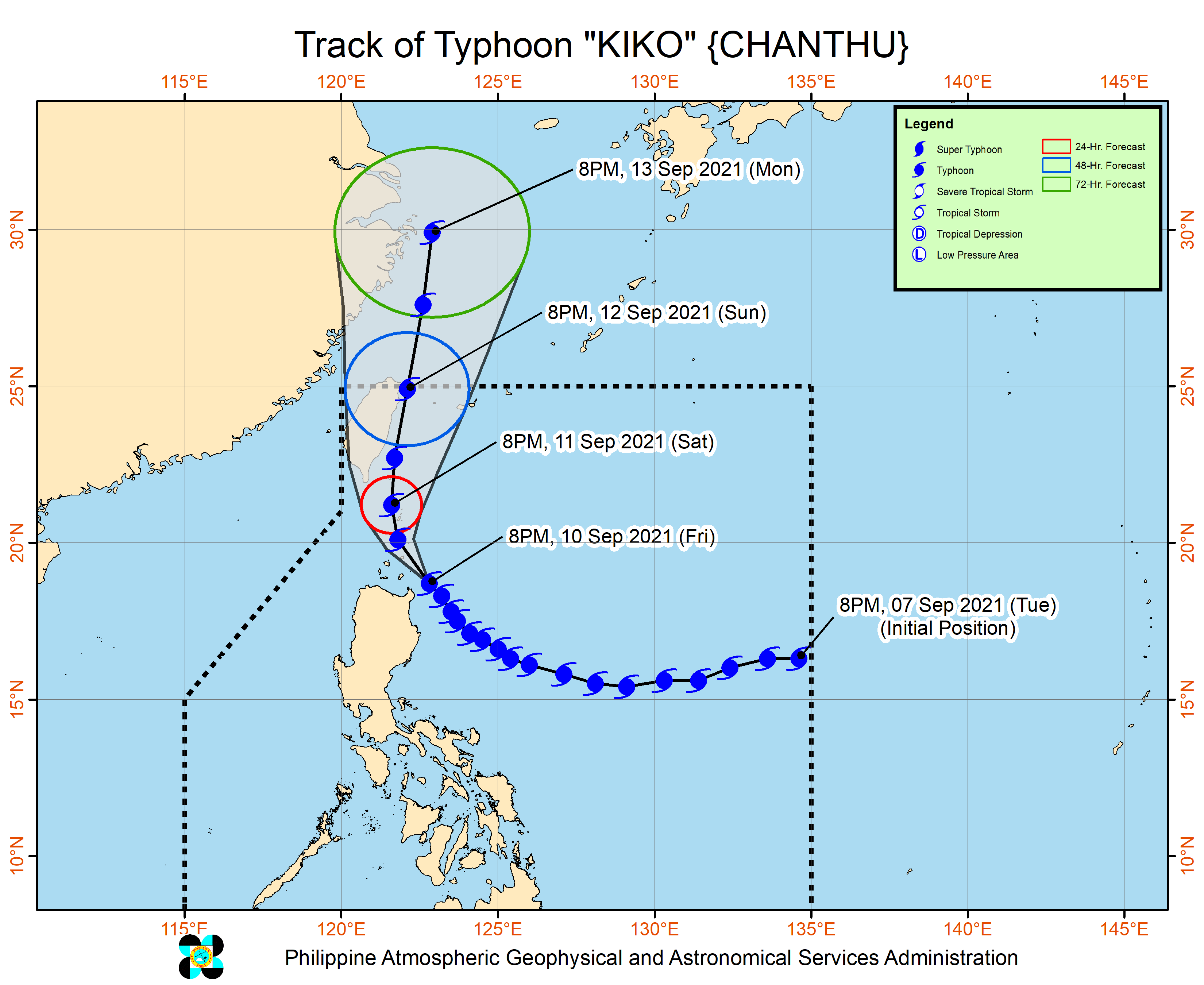
Between Friday evening and Saturday evening, September 11, Kiko will move over the coastal waters of northeastern mainland Cagayan, Babuyan Islands, and Batanes, according to PAGASA.
“The possibility of landfall over any of the islands of the Batanes-Babuyan archipelago is highly likely as the typhoon moves over these areas,” the state weather bureau warned.
“Nevertheless, catastrophic conditions will be felt over these areas during the passage whether a landfall occurs or not.”
At the moment, Kiko continues to have maximum sustained winds of 215 km/h and gustiness of up to 265 km/h.
PAGASA said the typhoon is likely to maintain its strength while crossing the Babuyan-Batanes area in the first half of Saturday, but may start to weaken within the day as it undergoes another eyewall replacement cycle.
“It must be noted, however, that the possibility of reaching super typhoon category is not yet ruled out within the next 12 hours,” the state weather bureau said.
A super typhoon has maximum sustained winds exceeding 220 km/h. (READ: FAST FACTS: Tropical cyclones, rainfall advisories)
The entire province of Batanes is already under Signal No. 4. This is the list of areas where tropical cyclone wind signals are raised as of 11 pm on Friday:
Signal No. 4 (very destructive typhoon-force winds)
- Batanes
- northeastern part of Babuyan Islands (Babuyan Island)
Signal No. 3 (destructive typhoon-force winds)
- extreme northeastern part of Cagayan (Santa Ana, Gonzaga)
- rest of Babuyan Islands
Signal No. 2 (damaging gale-force to storm-force winds)
- northern, central, and eastern parts of mainland Cagayan (Aparri, Camalaniugan, Lal-lo, Gattaran, Baggao, Peñablanca, Buguey, Santa Teresita, Tuguegarao City, Iguig, Amulung, Alcala, Allacapan, Lasam, Ballesteros, Abulug, Allacapan, Claveria, Santa Praxedes, Sanchez-Mira, Pamplona, Santo Niño)
- northeastern part of Isabela (San Pablo, Maconacon, Divilacan, Palanan)
- northern part of Apayao (Calanasan, Luna, Pudtol, Flora, Santa Marcela)
Signal No. 1 (strong winds)
- rest of mainland Cagayan
- northern part of Ilocos Norte (Pagudpud, Adams, Dumalneg, Bangui, Vintar, Carasi, Nueva Era, Piddig, Solsona, Burgos, Pasuquin, Bacarra, Laoag City, San Nicolas, Sarrat, Dingras)
- rest of Apayao
- northern part of Kalinga (Balbalan, Pinukpuk, Tabuk City, Rizal)
- eastern part of Mountain Province (Paracelis)
- northeastern part of Abra (Tineg, Lacub, Malibcong)
- northwestern and southeastern parts of Isabela (Dinapigue, Palanan, San Mariano, Cauayan City, Cabatuan, Aurora, Luna, Benito Soliven, Naguilian, Reina Mercedes, Ilagan City, Quezon, Burgos, Tumauini, San Manuel, Santo Tomas, Roxas, Santa Maria, Mallig, Quirino, Cabagan, Delfin Albano, Gamu)
If Kiko strengthens into a super typhoon, Signal No. 5 could be raised in some municipalities of Batanes and Babuyan Islands.
Rain from Kiko will persist until Saturday evening, possibly causing scattered to widespread floods and landslides.
Heavy to intense rain, with at times torrential rain
- northeastern part of Cagayan including Babuyan Islands
- Batanes
Moderate to heavy rain, with at times intense rain
- rest of Cagayan
- northern part of Isabela
- Ilocos Region
- Cordillera Administrative Region
PAGASA’s storm surge warning as of 11 pm on Friday shows there is now a moderate to high risk of life-threatening storm surges 2 to 3 meters high occurring on Saturday.
“Rising seawater along with the high waves from the shoreline moving inland may cause flooding in the low-lying coastal localities of Batanes, Cagayan including Babuyan Islands, and northern Isabela,” the state weather bureau also said.
Sea travel remains dangerous in areas affected by Kiko.
Rough to phenomenal seas (waves 3 to 16 meters high)
Travel risky for all vessels, mariners advised to remain in port
- seaboards of areas under tropical cyclone wind signals
Moderate to rough seas (waves 1.2 to 3 meters high)
Travel risky for small vessels, mariners advised to avoid navigation
- eastern seaboards of Central Luzon and Southern Luzon
After passing through the vicinity of extreme Northern Luzon, Kiko may move north or north northeast starting Sunday, September 12, and pass close to Taiwan’s east coast. Landfall in Taiwan, which is still within the Philippine Area of Responsibility (PAR), is not ruled out.
Finally, Kiko might leave PAR on Sunday evening or early Monday morning, September 13. Once outside, it will move north or north northeast over the East China Sea for the rest of Monday.
PAGASA also issued a separate advisory for the southwest monsoon or hanging habagat, which is still being enhanced by Kiko.
On Saturday, the enhanced southwest monsoon will trigger moderate to heavy rain in these areas:
- Palawan
- Occidental Mindoro
- Oriental Mindoro
- Cavite
- Batangas
- Bataan
- Zambales
- Antique
- northwestern part of Aklan
“Moreover, occasional gusty winds will be experienced over these areas, especially in the coastal and upland localities,” PAGASA said.
Metro Manila was also seeing rain from the southwest monsoon, the state weather bureau tweeted at 11 pm.
Flash floods and landslides could occur in areas affected by the southwest monsoon.

Kiko is the Philippines’ 11th tropical cyclone for 2021.
An average of 20 tropical cyclones form within or enter PAR each year. (READ: LIST: PAGASA’s names for tropical cyclones in 2021)
For the next six months, these are PAGASA’s estimates for the number of tropical cyclones inside PAR:
2021
- September – 2 or 3
- October – 2 or 3
- November – 2 or 3
- December – 1 or 2
2022
- January – 0 or 1
- February – 0 or 1
– Rappler.com
Add a comment
How does this make you feel?


There are no comments yet. Add your comment to start the conversation.