SUMMARY
This is AI generated summarization, which may have errors. For context, always refer to the full article.
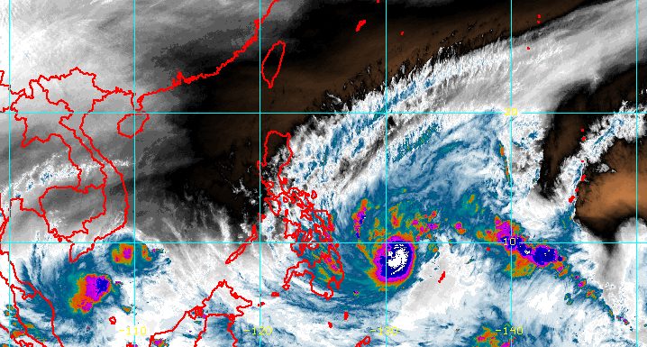
MANILA, Philippines – More areas were placed under tropical cyclone wind signals as Typhoon Odette (Rai) continued to intensify over the Philippine Sea on Wednesday afternoon, December 15.
Odette now has maximum sustained winds of 130 kilometers per hour from the previous 120 km/h and gustiness of up to 160 km/h from the previous 150 km/h.
The Philippine Atmospheric, Geophysical, and Astronomical Services Administration (PAGASA) also said in a briefing at 6 pm on Wednesday that Odette was already 485 kilometers east of Hinatuan, Surigao del Sur, moving west northwest at a slightly faster 25 km/h from 20 km/h in the morning.
The typhoon is still on course for landfall in Caraga or Eastern Visayas on Thursday afternoon or evening, December 16.
Before hitting land, Odette could reach a peak intensity of 155 km/h.
These are the areas where tropical cyclone wind signals are raised as of 5 pm on Wednesday:
Signal No. 2 (damaging gale- to storm-force winds)
- southern part of Eastern Samar (Borongan City, Maydolong, Balangkayan, Llorente, Lawaan, Balangiga, Giporlos, Quinapondan, General MacArthur, Hernani, Salcedo, Mercedes, Guiuan)
- southern part of Samar (Basey, Marabut, Santa Rita)
- Southern Leyte
- central and southern parts of Leyte (Ormoc City, Jaro, Alangalang, Tacloban City, Palompon, Merida, Isabel, Palo, Santa Fe, Pastrana, Tanauan, Dagami, Tabontabon, Tolosa, Julita, Dulag, Burauen, Albuera, Baybay City, La Paz, Mayorga, MacArthur, Javier, Abuyog, Mahaplag, Inopacan, Hindang, Hilongos, Bato, Matalom, Babatngon)
- Camotes Islands
- eastern part of Bohol (Garcia Hernandez, Jagna, Sierra Bullones, Dagohoy, Talibon, Trinidad, San Miguel, Pilar, Duero, Guindulman, Anda, Candijay, Alicia, Mabini, Ubay, Bien Unido, President Carlos P. Garcia)
- Surigao del Norte
- Surigao del Sur
- Dinagat Islands
- Agusan del Sur
- Agusan del Norte
- northeastern part of Bukidnon (Impasug-ong, Malitbog)
- eastern part of Misamis Oriental (Villanueva, Jasaan, Claveria, Balingasag, Lagonglong, Salay, Medina, Gingoog City, Magsaysay, Talisayan, Balingoan, Kinoguitan, Sugbongcogon, Binuangan)
- Camiguin
Signal No. 1 (strong winds)
- Catanduanes
- Camarines Sur
- Albay
- Sorsogon
- Masbate including Ticao and Burias Islands
- southern part of Quezon (Guinayangan, Lopez, Macalelon, General Luna, Catanauan, Buenavista, San Narciso, Mulanay, San Francisco, San Andres)
- Marinduque
- Romblon
- central and southern parts of Oriental Mindoro (Calapan City, Naujan, Victoria, Pola, Socorro, Pinamalayan, Gloria, Bansud, Bongabong, Roxas, Mansalay, Bulalacao)
- central and southern parts of Occidental Mindoro (Sablayan, Calintaan, Rizal, San Jose, Magsaysay)
- northern part of Palawan (Taytay, Dumaran, Araceli, El Nido, Calamian Islands, Cuyo Islands)
- Northern Samar
- rest of Eastern Samar
- rest of Samar
- Biliran
- rest of Leyte
- rest of Bohol
- Cebu
- Siquijor
- Negros Oriental
- Negros Occidental
- Guimaras
- Iloilo
- Antique
- Capiz
- Aklan
- northern part of Davao Oriental (Boston, Cateel)
- northern part of Davao de Oro (Monkayo, Compostela, Montevista, Laak)
- northern part of Davao del Norte (San Isidro, Kapalong)
- northwestern and central parts of Bukidnon (Malaybalay City, Cabanglasan, San Fernando, Valencia City, Lantapan, Talakag, Baungon, Libona, Sumilao, Manolo Fortich)
- rest of Misamis Oriental
- Misamis Occidental
- northern part of Lanao del Norte (Iligan City, Tagoloan, Pantar, Baloi, Matungao, Linamon, Kauswagan, Poona Piagapo, Bacolod, Maigo, Kolambugan, Munai)
- northern part of Zamboanga del Sur (Dumingag, Mahayag, Molave, Josefina)
- northwestern part of Zamboanga del Norte (Jose Dalman, Manukan, President Manuel A. Roxas, Katipunan, Sergio Osmeña Sr., Dipolog City, Polanco, Piñan, Mutia, Dapitan City, La Libertad, Rizal, Sibutad, Siayan, Sindangan, Bacungan, Salug, Godod, Liloy)
- northern part of Lanao del Sur (Tagoloan II, Kapai, Bubong)
The highest possible tropical cyclone wind signal due to Odette is Signal No. 3.
The typhoon will also dump massive rainfall in the next few days, which may trigger floods and landslides.
The eastern parts of Mindanao and the Visayas were the first to start experiencing rain from Odette’s trough or extension and outermost rainbands on Wednesday.
This is PAGASA’s rainfall forecast as of 5 pm:
Wednesday, December 15, until early Thursday morning, December 16
- Light to moderate rain, with at times heavy rain – Caraga, Davao Oriental, Eastern Samar, Samar, and Southern Leyte
Early Thursday morning, December 16, until early Friday morning, December 17
- Heavy to intense rain, with at times torrential rain – Dinagat Islands, Surigao del Norte, northern part of Surigao del Sur, Agusan del Norte, northern part of Agusan del Sur, Camiguin, Misamis Oriental, Southern Leyte, Bohol, Cebu, Siquijor, Negros Oriental, Negros Occidental
- Moderate to heavy rain, with at times intense rain – Leyte, southern part of Eastern Samar, southern part of Samar, Iloilo, Capiz, Aklan, Antique, Guimaras, northern part of Zamboanga del Norte, rest of Caraga
- Light to moderate rain, with at times heavy rain – Bicol, rest of Zamboanga del Norte, Oriental Mindoro, Romblon, rest of Visayas, rest of Northern Mindanao
Early Friday morning, December 17, until early Saturday morning, December 18
- Heavy to intense rain, with at times torrential rain – Western Visayas, northern and central parts of Palawan including Cuyo and Cagayancillo Islands
- Moderate to heavy rain, with at times intense rain – Occidental Mindoro, Oriental Mindoro, Negros Oriental
- Light to moderate rain, with at times heavy rain – Bicol, Zamboanga del Norte, Quezon, Aurora, eastern part of Cagayan, eastern part of Isabela, rest of Visayas

PAGASA also warned of “a minimal to moderate risk” of storm surges up to 2 meters high in the next 48 hours.
“Rising seawater along with the high waves from the shoreline moving inland may cause flooding in the low-lying coastal localities of southern portions of Eastern Samar and Samar, the rest of Visayas, southern portion of Masbate, Surigao del Norte, Surigao del Sur, Dinagat Islands, Camiguin, Misamis Oriental, Misamis Occidental, Lanao del Norte, Zamboanga del Norte, and the northern portion of Palawan,” the weather bureau said.
For the rest of Wednesday until Thursday, moderate to high seas are expected in seaboards of areas under tropical cyclone wind signals. Waves are estimated to be 1.2 to 7.5 meters high, making travel risky for all types of vessels.
A gale warning also remains in effect for these seaboards as Odette and the northeast monsoon or hanging amihan are causing rough to very rough seas:
- seaboards of Northern Luzon
- eastern seaboard of Central Luzon
- eastern and western seaboards of Southern Luzon
- western seaboard of Visayas
- eastern seaboard of Mindanao
PAGASA added that moderate to rough seas, with waves 1.2 to 3.1 meters high, are risky for small vessels in these seaboards:
- remaining seaboards of Central Luzon and Southern Luzon
- western and northern seaboards of Mindanao
After Odette’s initial landfall in Caraga or Eastern Visayas, it is seen to cross several provinces in Central Visayas and Western Visayas before emerging over the Sulu Sea on Friday morning or afternoon, December 17.
Then it could pass near to or over the Cuyo archipelago and cross the northern part of Palawan on Friday evening before finally exiting landmass toward the West Philippine Sea.
PAGASA said Odette may slightly weaken as it crosses the Visayas and Palawan, but it will remain a typhoon. It is also likely to reintensify over the West Philippine Sea.
Odette is the Philippines’ 15th tropical cyclone for 2021. Around 20 form within or enter the Philippine Area of Responsibility each year.
Here are PAGASA’s estimates for tropical cyclones in the coming months:
- December 2021 – 1 or 2
- January 2022 – 0 or 1
- February 2022 – 0 or 1
- March 2022 – 0 or 1
- April 2022 – 0 or 1
- May 2022 – 1 or 2
– Rappler.com
Add a comment
How does this make you feel?


There are no comments yet. Add your comment to start the conversation.