SUMMARY
This is AI generated summarization, which may have errors. For context, always refer to the full article.
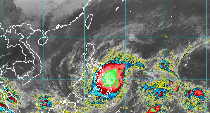
MANILA, Philippines – Parts of Mindanao and the Visayas were placed under Signal No. 4 late Thursday morning, December 16, as Typhoon Odette (Rai) intensified further ahead of its expected landfall in the Caraga region.
Odette now has maximum sustained winds of 185 kilometers per hour from the previous 165 km/h, while its gustiness increased to 230 km/h from the previous 205 km/h, the Philippine Atmospheric, Geophysical, and Astronomical Services Administration (PAGASA) said in a bulletin released past 11 am.
The typhoon’s intensification will continue until it makes landfall on Thursday afternoon, and it could reach a peak intensity of 195 km/h.
PAGASA warned that Odette is endangering the Bucas Grande-Siargao Islands area and Dinagat Islands – the possible areas where the typhoon could make its initial landfall between 1 pm and 3 pm on Thursday.
As of late Thursday morning, Odette was already 175 kilometers east of Surigao City, Surigao del Norte, still moving west northwest at 25 km/h.
Here are the areas covered by tropical cyclone wind signals as of 11 am:
Signal No. 4 (very destructive typhoon-force winds)
- Southern Leyte
- eastern part of Bohol (Talibon, Trinidad, San Miguel, Dagohoy, Pilar, Sierra Bullones, Jagna, Garcia Hernandez, Duero, Guindulman, Anda, Candijay, Alicia, Mabini, Ubay, President Carlos P. Garcia, Bien Unido)
- Dinagat Islands
- Surigao del Norte including Siargao and Bucas Grande Islands
Signal No. 3 (destructive typhoon-force winds)
- southern part of Leyte (Abuyog, Mahaplag, Hilongos, Bato, Matalom, Hindang, Inopacan, Baybay City, Javier, MacArthur)
- southern and central parts of Cebu (Camotes Islands, Tuburan, Catmon, Carmen, Danao City, Asturias, Balamban, Cebu City, Compostela, Liloan, Consolacion, Lapu-Lapu City, Mandaue City, Toledo City, Talisay City, Minglanilla, Samboan, Sibonga, Alcoy, Ginatilan, Boljoon, Carcar City, Malabuyoc, Moalboal, Cordova, Oslob, Aloguinsan, Pinamungahan, Barili, Santander, Badian, Dalaguete, Alcantara, Ronda, Alegria, Naga City, Argao, San Fernando, Dumanjug, Sogod)
- rest of Bohol
- Negros Oriental
- Siquijor
- southern and central parts of Negros Occidental (Calatrava, San Carlos City, Salvador Benedicto, Talisay City, Silay City, Bacolod City, Murcia, Bago City, Valladolid, Pulupandan, La Carlota City, San Enrique, La Castellana, Moises Padilla, Pontevedra, Hinigaran, Isabela, Binalbagan, Himamaylan City, Kabankalan City, Ilog, Cauayan, Candoni, Sipalay City, Hinoba-an)
- Guimaras
- northern part of Agusan del Norte (Kitcharao, Jabonga, Santiago, Tubay, Cabadbaran City)
- northern part of Surigao del Sur (Carrascal, Cantilan, Madrid, Carmen, Lanuza, Cortes, Tandag City)
Signal No. 2 (damaging gale- to storm-force winds)
- southern part of Albay (Tabaco City, Malilipot, Rapu-Rapu, Bacacay, Santo Domingo, Legazpi City, Manito, Camalig, Daraga, Jovellar, Guinobatan, Pio Duran, Ligao City, Oas)
- Sorsogon
- Masbate including Ticao and Burias Islands
- Romblon
- central and southern parts of Oriental Mindoro (Pinamalayan, Gloria, Bansud, Bongabong, Roxas, Mansalay, Bulalacao, Socorro, Pola)
- central and southern parts of Occidental Mindoro (Sablayan, Calintaan, Rizal, San Jose, Magsaysay)
- Palawan (El Nido, Calamian Islands, Taytay, Dumaran, Araceli, Cuyo Islands)
- Northern Samar
- Eastern Samar
- Samar
- Biliran
- rest of Leyte
- rest of Cebu
- rest of Negros Occidental
- Iloilo
- Capiz
- Aklan
- Antique
- rest of Surigao del Sur
- Agusan del Sur
- rest of Agusan del Norte
- extreme northern part of Zamboanga del Norte (Dapitan City, Siayan, Sindangan, Jose Dalman, Manukan, President Manuel A. Roxas, Katipunan, Sergio Osmeña Sr., Polanco, Dipolog City, Piñan, Mutia, La Libertad, Rizal, Sibutad)
- extreme northern part of Zamboanga del Sur (Josefina, Molave, Mahayag, Dumingag, Tambulig)
- Misamis Occidental
- northern part of Lanao del Norte (Kolambugan, Maigo, Munai, Bacolod, Poona Piagapo, Kauswagan, Pantao Ragat, Matungao, Linamon, Baloi, Tagoloan, Pantar, Iligan City)
- Misamis Oriental
- Camiguin
- northern part of Bukidnon (Cabanglasan, Malaybalay City, Lantapan, Talakag, Baungon, Libona, Manolo Fortich, Sumilao, Impasug-ong, Malitbog)
- northern part of Lanao del Sur (Tagoloan II, Kapai)
Signal No. 1 (strong winds)
- Catanduanes
- Camarines Norte
- Camarines Sur
- rest of Albay
- Marinduque
- southern part of Quezon (San Antonio, Tiaong, Candelaria, Sariaya, Dolores, Lucena City, Pagbilao, Padre Burgos, Atimonan, Agdangan, Unisan, Gumaca, Plaridel, Pitogo, Lopez, Guinayangan, Buenavista, Catanauan, General Luna, Macalelon, Mulanay, San Narciso, San Andres, San Francisco, Tagkawayan, Calauag, Quezon, Alabat, Tayabas City, Perez)
- Batangas
- rest of Oriental Mindoro
- rest of Occidental Mindoro
- rest of mainland Palawan including Balabac and Kalayaan Islands
- northern part of Davao Oriental (Baganga, Cateel, Boston)
- northern part of Davao de Oro (Laak, Mawab, Nabunturan, Montevista, Monkayo, New Bataan, Compostela)
- northern part of Davao del Norte (Talaingod, Santo Tomas, Kapalong, Asuncion, San Isidro, New Corella)
- rest of Bukidnon
- rest of Lanao del Norte
- rest of Lanao del Sur
- rest of northern part of Zamboanga del Norte (Labason, Kalawit, Tampilisan, Liloy, Salug, Godod, Bacungan, Gutalac, Baliguian)
- rest of northern part of Zamboanga del Sur (Bayog, Lakewood, Kumalarang, Guipos, Dumalinao, Tukuran, Ramon Magsaysay, Aurora, Sominot, Tigbao, Labangan, Pagadian City, Midsalip)
- northern part of Zamboanga Sibugay (Titay, Ipil, Naga, Kabasalan, Siay, Diplahan, Buug)
Meanwhile, rain from Odette is torrential in areas directly in or near the typhoon’s path. PAGASA stressed that scattered to widespread floods and landslides could occur in the affected provinces and regions.
Thursday, December 16, until early Friday morning, December 17
- Heavy to torrential rain – Caraga, Central Visayas, Misamis Oriental, Camiguin, Southern Leyte, Negros Occidental
- Moderate to heavy rain, with at times intense rain – Leyte, southern part of Eastern Samar, southern part of Samar, Zamboanga del Norte, Lanao del Sur, Davao Oriental, Davao de Oro, Davao del Norte, rest of Northern Mindanao
- Light to moderate rain, with at times heavy rain – Bicol, Quezon, rest of Visayas, rest of Zamboanga Peninsula, rest of mainland Bangsamoro Autonomous Region in Muslim Mindanao
Early Friday morning, December 17, until early Saturday morning, December 18
- Heavy to intense rain, with at times torrential rain – Central Visayas, Western Visayas, Palawan including Calamian, Cuyo, and Cagayancillo Islands
- Moderate to heavy rain, with at times intense rain – Bicol, Zamboanga Peninsula, Quezon, Occidental Mindoro, Oriental Mindoro, Romblon, Marinduque, Lanao del Norte, Lanao del Sur, rest of Visayas
- Light to moderate rain, with at times heavy rain – Caraga, southern part of Aurora, rest of Northern Mindanao
Early Saturday morning, December 18, until early Sunday morning, December 19
- Heavy to torrential rain – Kalayaan Islands
- Light to moderate rain, with at times heavy rain – Cagayan Valley, Aurora, Quezon, mainland Palawan, Calamian Islands
PAGASA also reiterated that there is a “moderate to high risk” of storm surges up to 3 meters high “which may cause life-threatening flooding in the low-lying coastal areas of Central Visayas, Northern Mindanao, Iloilo, Guimaras, Negros Occidental, Eastern Samar, Southern Leyte, Dinagat Islands, Surigao del Norte, Surigao del Sur, Agusan del Norte, and several localities in the northern portion of Palawan including Calamian, Cuyo, and Cagayancillo Islands, Antique, the southern portion of Samar, Leyte, and Davao Oriental.”

On Thursday, moderate to very high seas are expected in seaboards of areas under tropical cyclone wind signals. Waves are estimated to be 1.2 to 10 meters high, making travel risky for all types of vessels.
Coastal waters not under any tropical cyclone wind signal in the seaboards of Northern Luzon and in the eastern seaboards of Central Luzon and Southern Luzon also remain under a gale warning due to the typhoon and the northeast monsoon or hanging amihan. Seas are rough to very rough, with waves 2.8 to 4.5 meters high.
The remaining seaboards of the Philippines not under any wind signal will have moderate to rough seas. Waves are 1.2 to 3.1 meters high and conditions are risky for small vessels.
After its first landfall on Thursday, Odette is seen to cross several provinces in Central Visayas and Western Visayas before emerging over the Sulu Sea on Friday morning, December 17.
Then it could pass near or in the vicinity of Cuyo or Cagayancillo and cross the northern or central part of Palawan on Friday afternoon or evening before finally exiting landmass toward the West Philippine Sea.
PAGASA said Odette may slightly weaken as it crosses northeastern Mindanao, the Visayas, and Palawan, but it will remain a typhoon. It is also likely to reintensify over the West Philippine Sea.
The typhoon could start to weaken again on Saturday evening, December 18, or Sunday, December 19, however, as it “becomes exposed to increasing vertical wind shear and the surge of the northeast monsoon,” the weather bureau said.
By that time, it would already be outside the Philippine Area of Responsibility. Odette could exit PAR by Saturday afternoon.
Odette is the Philippines’ 15th tropical cyclone for 2021. Around 20 form within or enter PAR each year.
Here are PAGASA’s estimates for tropical cyclones in the coming months:
- December 2021 – 1 or 2
- January 2022 – 0 or 1
- February 2022 – 0 or 1
- March 2022 – 0 or 1
- April 2022 – 0 or 1
- May 2022 – 1 or 2
– Rappler.com
Add a comment
How does this make you feel?


There are no comments yet. Add your comment to start the conversation.