SUMMARY
This is AI generated summarization, which may have errors. For context, always refer to the full article.
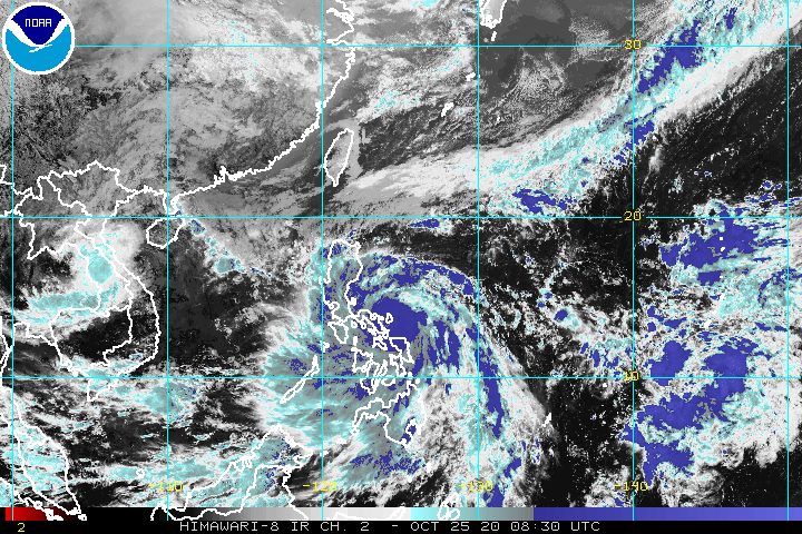
Quinta (Molave) intensified from a severe tropical storm into a typhoon at 2 pm on Sunday, October 25, just a few hours before its looming landfall in the region of Bicol.
In a bulletin released past 5 pm on Sunday, the Philippine Atmospheric, Geophysical, and Astronomical Services Administration (PAGASA) said Quinta is now 70 kilometers east northeast of Legazpi City, Albay.
The typhoon continues to move west toward Bicol at 25 kilometers per hour (km/h).
Quinta is now expected to make landfall either in the eastern coast of Camarines Sur or the northeastern coast of Albay between 6 pm and 8 pm on Sunday. PAGASA earlier said Quinta could make landfall in Catanduanes or Albay.
After hitting land, Quinta will cross Southern Luzon until Monday afternoon, October 26, then emerge over the West Philippine Sea.
Quinta’s maximum winds increased to 130 km/h from the previous 110 km/h, while its gustiness is now up to 160 km/h from the previous 135 km/h. Once the typhoon is already over the West Philippine Sea, it is likely to strengthen further. (READ: FAST FACTS: Tropical cyclones, rainfall advisories)
Below are the areas where tropical cyclone wind signals are raised as of 5 pm on Sunday. Signal No. 3 has been raised for the first time due to Quinta.
Signal No. 3
- Catanduanes
- eastern part of Camarines Sur (Goa, Ocampo, Bula, Lagonoy, Garchitorena, Caramoan, Presentacion, San Jose, Tigaon, Sagñay, Buhi, Iriga City, Baao, Nabua, Bato, Balatan)
- Albay
- Sorsogon
- Burias and Ticao Islands
Signal No. 2
- Camarines Norte
- rest of Camarines Sur
- Masbate
- central and southern parts of Quezon (Mauban, Sampaloc, Lucban, Dolores, Candelaria, Tiaong, San Antonio, Sariaya, Tayabas City, Lucena City, Pagbilao, Atimonan, Perez, Alabat, Calauag, Quezon, Tagkawayan, Guinayangan, Lopez, Pitogo, Plaridel, Gumaca, Unisan, Agdangan, Padre Burgos, Macalelon, Catanauan, General Luna, Buenavista, San Narciso, Mulanay, San Andres, San Francisco)
- southeastern part of Laguna (Paete, Kalayaan, Lumban, Cavinti, Luisiana, Majayjay, Liliw, Rizal, Nagcarlan, San Pablo City, Alaminos, Magdalena, Pagsanjan)
- Batangas
- Marinduque
- Romblon
- Oriental Mindoro
- Occidental Mindoro including Lubang Island
- Northern Samar
Signal No. 1
- rest of Quezon
- rest of Laguna
- Rizal
- Cavite
- Metro Manila
- Bulacan
- Pampanga
- Bataan
- southern part of Zambales (San Marcelino, San Felipe, San Narciso, Castillejos, Subic, San Antonio, Olongapo City, Botolan, Cabangan)
- Calamian Islands
- northern part of Samar (Calbayog City, Matuguinao, Tagapul-an, Santo Niño, Almagro, Santa Margarita, Gandara, San Jose de Buan, Pagsanghan, Tarangnan, San Jorge, Catbalogan City, Jiabong, Motiong, Paranas)
- northern part of Eastern Samar (Maslog, Jipapad, Arteche, San Policarpo, Oras, Dolores, Can-avid, Taft)
- northern part of Capiz (Sapi-an, Ivisan, Roxas City, Panay, Pilar, Pontevedra, President Roxas)
- Aklan
- northern part of Antique (Caluya, Libertad, Pandan, Sebaste, Culasi)
- northeastern part of Iloilo (Batad, Balasan, Estancia, Carles)
PAGASA said typhoon-force winds will be experienced in areas under Signal No. 3, storm-force winds in areas under Signal No. 2, and strong breeze to near gale conditions in areas under Signal No. 1.
Strong breeze to gale conditions from a northeasterly surge will also persist in the following areas:
- Batanes
- Babuyan Islands
- northern coastal areas of Ilocos Norte and mainland Cagayan
Here is PAGASA’s rainfall forecast for Sunday evening until Monday morning, with rain coming from both Quinta and the tail-end of a frontal system.
Moderate to heavy rain, with at times intense rain (Quinta)
- Bicol
- Calabarzon
- Aurora
- Occidental Mindoro
- Oriental Mindoro
- Romblon
- Marinduque
- Calamian Islands
- Northern Samar
- Eastern Samar
- Samar
- Biliran
- Aklan
- Capiz
- Antique
Moderate to heavy rain, with at times intense rain (tail-end of a frontal system)
- Cagayan
- Isabela
- Apayao
- Ilocos Norte
Light to moderate rain, with at times heavy rain (Quinta and tail-end of a frontal system)
- rest of Luzon
- rest of Visayas
- Zamboanga Peninsula
- Bangsamoro Autonomous Region in Muslim Mindanao
- Northern Mindanao
- Caraga
There could be floods and landslides, as well as “sediment-laden streamflows” such as lahar in areas near Mayon Volcano.
PAGASA also warned that storm surges 1 to 2 meters high may affect coastal areas of the following:
- Northern Samar
- Bicol
- central and southern parts of Quezon
Sea travel remains risky, especially for small vessels.
Rough to high seas
- areas under Signal Nos. 1, 2, and 3 (waves 2.5 to 8 meters high)
Rough to very rough seas
- seaboards of Northern Luzon (waves 3 to 5.5 meters high)
- seaboards of Aurora, Zambales, and northern part of Palawan including Calamian and Kalayaan Islands (waves 2.5 to 4.5 meters high)
Waters elsewhere could be dangerous as well for small vessels and “inexperienced mariners,” according to PAGASA.
Moderate to rough seas
- other seaboards of the Philippines (waves 1.2 to 2.8 meters high)
Based on its latest forecast track, Quinta might leave the Philippine Area of Responsibility (PAR) on Tuesday afternoon, October 27.
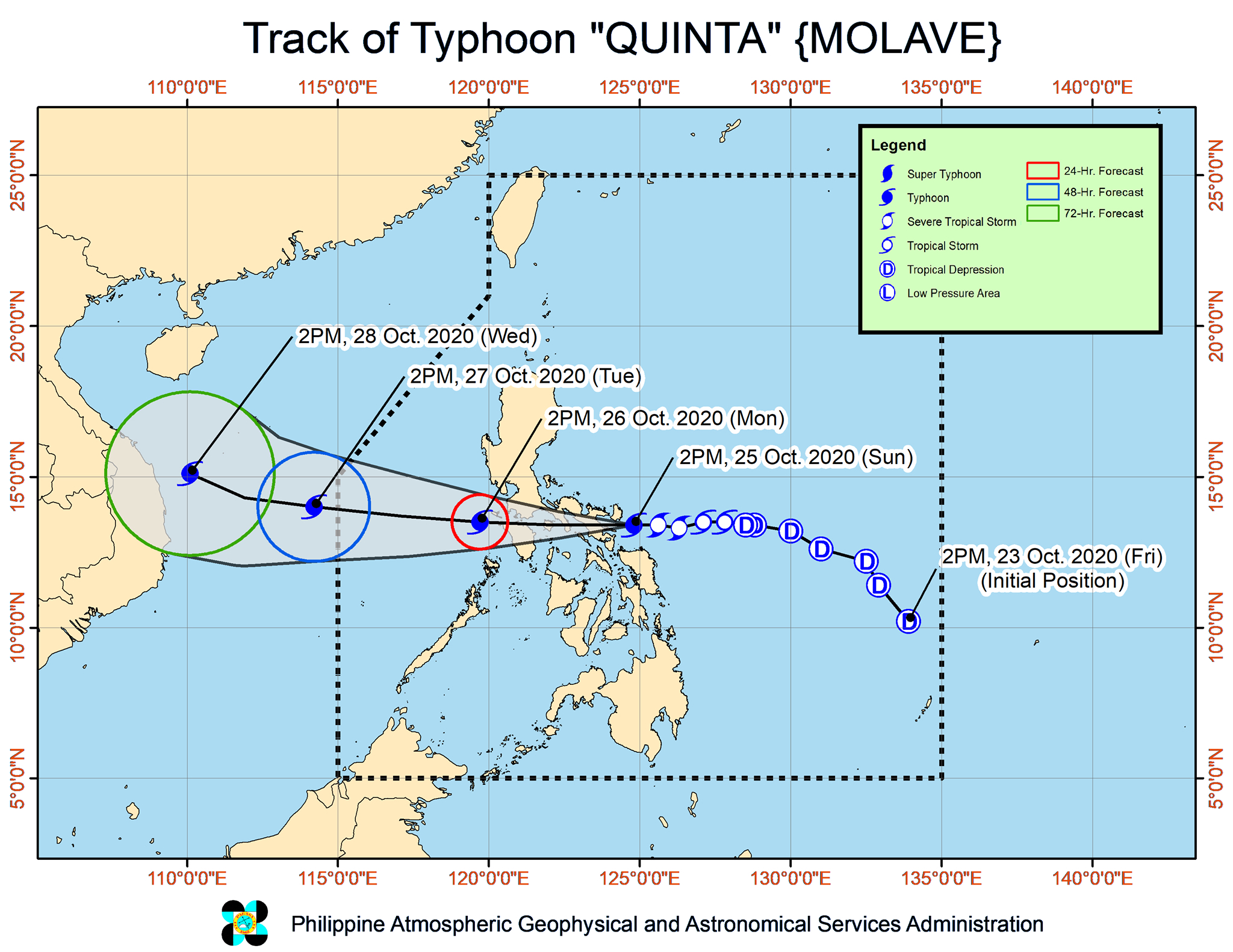
Quinta is the Philippines’ 17th tropical cyclone for 2020, and the 4th for October.
An average of 20 tropical cyclones form within or enter PAR each year. (READ: LIST: PAGASA’s names for tropical cyclones in 2020)
These are PAGASA’s latest estimates for the number of tropical cyclones inside PAR in the next 6 months:
- November 2020 – 1 to 3
- December 2020 – 2 or 3
- January 2021 – 0 or 1
- February 2021 – 0 or 1
- March 2021 – 0 or 1
- April 2021 – 0 or 1
Last October 2, the state weather bureau warned Filipinos to expect more rain in the coming months due to the onset of La Niña. – Rappler.com
Add a comment
How does this make you feel?


There are no comments yet. Add your comment to start the conversation.