SUMMARY
This is AI generated summarization, which may have errors. For context, always refer to the full article.
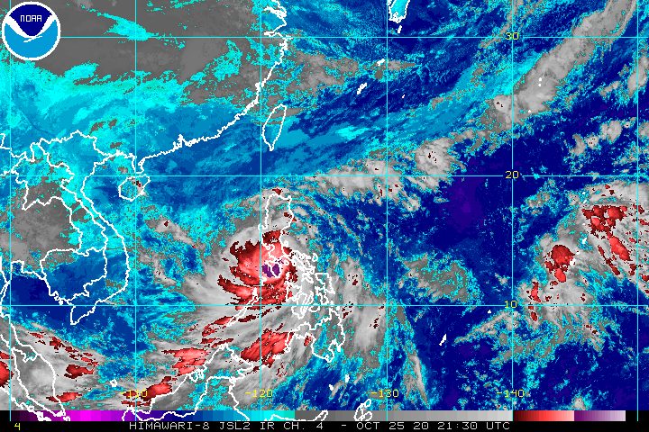
Typhoon Quinta (Molave) has now made landfall a total of 5 times in the Philippines, bringing intense rain and destructive winds to provinces directly in its path.
Quinta’s 5 landfalls were in the following areas:
- San Miguel Island, Tabaco City, Albay – 6:10 pm, Sunday, October 25
- Malinao, Albay – 6:50 pm, Sunday
- San Andres, Quezon – 10:30 pm, Sunday
- Torrijos, Marinduque – 1:20 am, Monday, October 26
- Pola, Oriental Mindoro – 3:30 am, Monday
The Philippine Atmospheric, Geophysical, and Astronomical Services Administration (PAGASA) said in its 5 am bulletin on Monday that Quinta is already in the vicinity of Socorro, Oriental Mindoro.
The typhoon slightly slowed down, moving west at 25 kilometers per hour (km/h) from the previous 30 km/h.
It will cross Mindoro Island – divided into Oriental Mindoro and Occidental Mindoro – then emerge over the West Philippine Sea on Monday morning.
At the moment, Quinta still has maximum winds of 125 km/h, with gustiness of up to 180 km/h. PAGASA said it will remain a typhoon while crossing Mindoro Island, then strengthen again over the West Philippine Sea, eventually reaching its peak intensity within 24 to 48 hours. (READ: FAST FACTS: Tropical cyclones, rainfall advisories)
Below is the latest list of areas under tropical cyclone wind signals.
Signal No. 3
- southern part of Quezon (Mulanay, San Francisco, Catanauan, General Luna, Macalelon, Pitogo, Unisan, Agdangan, Padre Burgos, Pagbilao, Lucena City, Sariaya, Candelaria, Tiaong, San Antonio, Dolores, Tayabas City)
- southern part of Batangas (Lian, Tuy, San Juan, Rosario, Padre Garcia, Lipa City, Cuenca, San Jose, Ibaan, Taysan, Lobo, Batangas City, Mabini, Tingloy, San Pascual, Bauan, Alitagtag, San Luis, Taal, Santa Teresita, Calatagan, Balayan, Calaca, Lemery, Agoncillo, San Nicolas, Mataas Na Kahoy)
- northern part of Romblon (Concepcion, Banton, Corcuera, Romblon, San Agustin, Calatrava, San Andres, Odiongan, Santa Maria)
- Marinduque
- northern and central parts of Oriental Mindoro (Mansalay, Roxas, Bongabong, Bansud, Gloria, Pinamalayan, Pola, Socorro, Victoria, Naujan, Calapan City, Baco, San Teodoro, Puerto Galera)
- northern and central parts of Occidental Mindoro (San Jose, Rizal, Calintaan, Sablayan, Santa Cruz, Mamburao, Paluan, Abra de Ilog) including Lubang Island
Signal No. 2
- Camarines Norte
- western part of Camarines Sur (Siruma, Tinambac, Calabanga, Naga City, Pili, Bula, Balatan, Minalabac, Milaor, Bombon, Magarao, Canaman, Camaligan, Gainza, San Fernando, Pasacao, Pamplona, Cabusao, Libmanan, Sipocot, Lupi, Ragay, Del Gallego)
- Burias Island
- rest of Quezon including Polillo Island
- Laguna
- rest of Batangas
- Cavite
- Rizal
- Metro Manila
- southern part of Bulacan (Norzagaray, Angat, San Rafael, Baliuag, Pulilan, Calumpit, Hagonoy, Paombong, Malolos City, Plaridel, Bustos, San Jose del Monte City, Santa Maria, Pandi, Guiguinto, Balagtas, Bulacan, Bocaue, Meycauayan City, Obando, Marilao)
- southern part of Pampanga (Lubao, Sasmuan, Macabebe, Masantol, Minalin, Apalit)
- Bataan
- rest of Romblon
- rest of Oriental Mindoro
- rest of Occidental Mindoro
- Calamian Islands
- extreme northern part of Antique (Caluya)
Signal No. 1
- Catanduanes
- rest of Camarines Sur
- Albay
- western part of Sorsogon (Donsol, Pilar, Castilla, Sorsogon City, Casiguran, Juban, Magallanes, Bulan, Irosin)
- northern part of mainland Masbate (Uson, Mobo, Masbate City, Baleno, Aroroy, Balud, Mandaon, Milagros) including Ticao Island
- southern part of Aurora (Dingalan, San Luis)
- southern part of Nueva Ecija (Gabaldon, Laur, Palayan City, General Tinio, Cabanatuan City, Aliaga, Zaragoza, Jaen, San Antonio, Santa Rosa, Peñaranda, Gapan City, San Leonardo, San Isidro, Cabiao)
- southern part of Tarlac (La Paz, Tarlac City, San Jose, Concepcion, Capas, Bamban)
- rest of Bulacan
- rest of Pampanga
- central and southern parts of Zambales (Iba, Botolan, Cabangan, San Felipe, San Narciso, San Antonio, San Marcelino, Castillejos, Subic, Olongapo City)
- northern part of Palawan (El Nido, Taytay) including Cuyo Islands
- rest of northern part of Antique (Laua-an, Barbaza, Tibiao, Culasi, Sebaste, Pandan, Libertad)
- Aklan
- Capiz
- northern part of Iloilo (Lemery, Sara, San Dionisio, Batad, Estancia, Carles, Balasan)
PAGASA warned of destructive typhoon-force winds in areas under Signal No. 3, damaging gale to storm-force winds in areas under Signal No. 2, and strong breeze to near gale conditions in areas under Signal No. 1.
Strong breeze to gale conditions from a northeasterly surge will also be felt in these areas:
- Ilocos Region
- Batanes
- Cagayan
- Apayao
- northern part of Zambales
Meanwhile, here is PAGASA’s latest rainfall forecast for Monday, both for Quinta and the tail-end of a frontal system:
Moderate to heavy rain, with at times intense rain (Quinta)
- Camarines Norte
- Camarines Sur
- Calabarzon
- Occidental Mindoro
- Oriental Mindoro
- Marinduque
- Romblon
- northern part of Palawan including Calamian and Cuyo Islands
- Aklan
- Capiz
- Antique
Moderate to heavy rain (tail-end of a frontal system)
- Cagayan
- Isabela
- Apayao
- Kalinga
- Abra
- Ilocos Norte
- Ilocos Sur
Light to moderate rain, with at times heavy rain (Quinta and tail-end of a frontal system)
- rest of Luzon
- rest of Visayas
- Zamboanga Peninsula
- Bangsamoro Autonomous Region in Muslim Mindanao
- Northern Mindanao
- Caraga
The public must continue to watch out for floods, landslides, and even lahar in areas around Mayon Volcano.
Classes were suspended in some areas for Monday, as local government units anticipate difficulties with conducting distance learning in the middle of a typhoon.
The threat of storm surges remains present as well.
2 to 3 meters high
- coastal areas of Camarines Norte
- northern coastal areas of Quezon including Polillo Island and Camarines Sur
1 to 2 meters high
- coastal areas of Batangas, Marinduque, Occidental Mindoro, Oriental Mindoro, Romblon, Masbate, Albay, Sorsogon, and Catanduanes
- remaining coastal areas of Quezon and Camarines Sur
In addition, travel is still risky for all types of vessels in these waters:
Rough to high seas
- areas under Signal Nos. 1, 2, and 3 (waves 2.5 to 7 meters high)
Rough to very rough seas
- remaining seaboards of Luzon (waves 2.5 to 5 meters high)
- western, northern, and eastern seaboards of Visayas (waves 2.5 to 5 meters high)
The state weather bureau also reiterated that sailing in waters elsewhere in the country is not recommended for “inexperienced mariners,” while those with small vessels should take precautionary measures.
Moderate to rough seas
- other seaboards of the Philippines (waves 1.2 to 3.1 meters high)
If Quinta generally maintains its speed, it would leave the Philippine Area of Responsibility (PAR) on Tuesday morning, October 27.
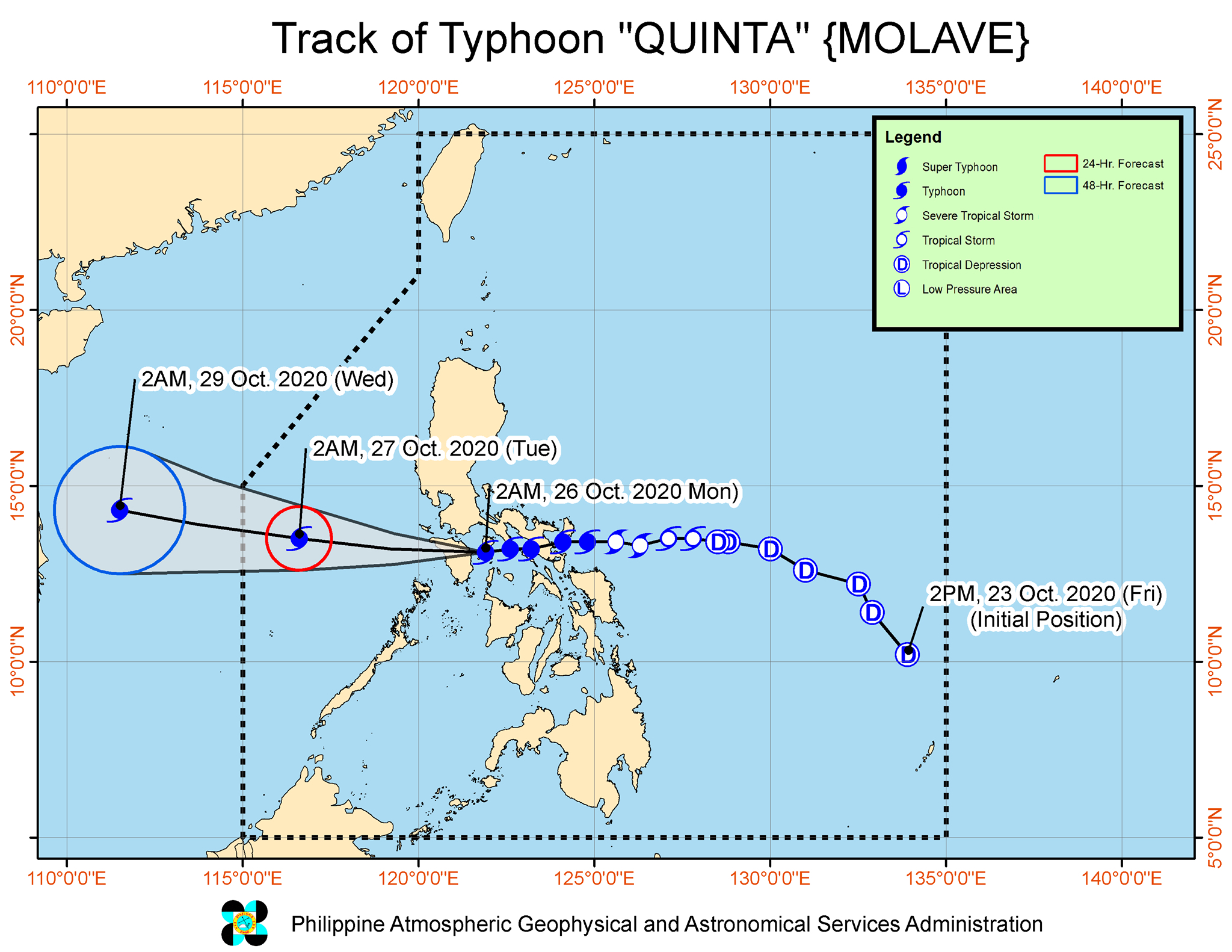
Quinta is the Philippines’ 17th tropical cyclone for 2020, and the 4th for October.
An average of 20 tropical cyclones form within or enter PAR each year. (READ: LIST: PAGASA’s names for tropical cyclones in 2020)
These are PAGASA’s latest estimates for the number of tropical cyclones inside PAR in the next 6 months:
- November 2020 – 1 to 3
- December 2020 – 2 or 3
- January 2021 – 0 or 1
- February 2021 – 0 or 1
- March 2021 – 0 or 1
- April 2021 – 0 or 1
Last October 2, the state weather bureau warned Filipinos to expect more rain in the coming months due to the onset of La Niña. – Rappler.com
Add a comment
How does this make you feel?


There are no comments yet. Add your comment to start the conversation.