SUMMARY
This is AI generated summarization, which may have errors. For context, always refer to the full article.
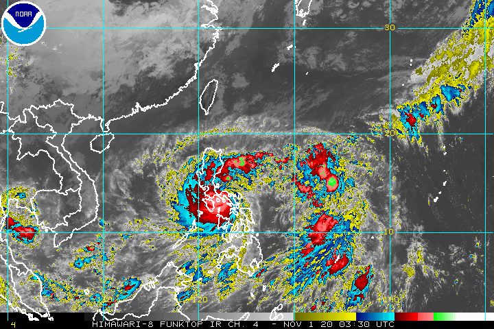
Rolly (Goni) weakened from a super typhoon into a typhoon at 8 am on Sunday, November 1, though PAGASA warned that it is still bringing violent winds and torrential rain.
Tropical cyclones commonly weaken after hitting land. Rolly made landfall first in Bato, Catanduanes, at 4:50 am on Sunday, then in Tiwi, Albay, at 7:20 am.
In a bulletin past 11 am on Sunday, the Philippine Atmospheric, Geophysical, and Astronomical Services Administration (PAGASA) said Rolly is now over the coastal waters of Pasacao, Camarines Sur, or 30 kilometers west southwest of Pili, Camarines Sur. It continues to move west at 25 kilometers per hour (km/h).
Its maximum sustained winds slightly went down to 215 km/h from the previous 225 km/h at the time of landfall, while its gustiness decreased to 295 km/h from the previous 310 km/h. A super typhoon has maximum winds exceeding 220 km/h.
Rolly remains the world’s strongest tropical cyclone for 2020, so far. (READ: FAST FACTS: Tropical cyclones, rainfall advisories)
PAGASA warned that “catastrophic violent winds and intense to torrential rainfall” from Rolly’s eyewall and inner rainbands are “prevailing or expected within the next 12 hours” in these areas:
- western part of Camarines Sur
- Marinduque
- central and southern parts of Quezon
- Laguna
- eastern part of Batangas
- Cavite
The situation is “particularly dangerous” in those areas, added the state weather bureau.
With Rolly back to typhoon status, there are no more areas under Signal No. 5. However, many places remain under Signal Nos. 1 to 4. Here are the areas covered as of 11 am on Sunday:
Signal No. 4 (very destructive to devastating typhoon-force winds)
- Camarines Norte
- Camarines Sur
- Catanduanes
- Albay
- northern part of Sorsogon (Donsol, Pilar, Castilla, Sorsogon City, Prieto Diaz, Gubat, Barcelona, Juban, Casiguran, Magallanes)
- Burias Island
- Marinduque
- Metro Manila
- Cavite
- Laguna
- Batangas
- Rizal
- Quezon including Polillo Island
- Pampanga
- Bulacan
- southern part of Aurora (Dingalan)
- Bataan
- southern part of Zambales (San Marcelino, San Felipe, San Narciso, San Antonio, Castillejos, Subic, Olongapo City, Botolan, Cabangan)
- northwestern part of Occidental Mindoro (Mamburao, Paluan) including Lubang Island
- northern part of Oriental Mindoro (Puerto Galera, San Teodoro, Baco, Calapan City, Naujan, Pola, Victoria, Socorro, Pinamalayan)
Signal No. 3 (destructive typhoon-force winds)
- rest of Sorsogon
- northern part of Masbate (Mobo, Masbate City, Milagros, Uson, Baleno, Aroroy, Mandaon) including Ticao Island
- rest of Zambales
- Romblon
- rest of Occidental Mindoro
- rest of Oriental Mindoro
- Tarlac
- southern part of Nueva Ecija (Cuyapo, Talugtug, Muñoz City, Llanera, Rizal, Bongabon, Gabaldon, General Tinio, Laur, Palayan City, General Mamerto Natividad, Cabanatuan City, Santa Rosa, Peñaranda, Gapan City, San Isidro, Cabiao, San Antonio, Jaen, San Leonardo, Zaragoza, Aliaga, Talavera, Santo Domingo, Quezon, Licab, Guimba, Nampicuan)
- central part of Aurora (San Luis, Baler, Maria Aurora)
- Northern Samar
Signal No. 2 (damaging gale- to storm-force winds)
- rest of Aurora
- Nueva Vizcaya
- Quirino
- Benguet
- La Union
- Pangasinan
- rest of Nueva Ecija
- rest of Masbate
- northern part of Samar (Catbalogan City, Jiabong, Motiong, Paranas, Hinabangan, San Sebastian, Tarangnan, Pagsanghan, San Jorge, San Jose de Buan, Matuguinao, Gandara, Santa Margarita, Calbayog City, Santo Niño, Almagro, Tagapul-an)
- northern part of Eastern Samar (San Julian, Sulat, Taft, Can-avid, Dolores, Maslog, Oras, San Policarpo, Arteche, Jipapad)
- extreme northern part of Antique (Pandan, Libertad, Caluya)
- northwestern part of Aklan (Buruanga, Malay, Nabas, Ibajay)
Signal No. 1 (strong breeze to near gale conditions)
- mainland Cagayan
- Isabela
- Apayao
- Kalinga
- Mountain Province
- Ifugao
- Abra
- Ilocos Norte
- Ilocos Sur
- northern part of Palawan (El Nido, Taytay, Dumaran, Araceli) including Calamian and Cuyo Islands
- rest of northern part of Antique (Sebaste, Culasi, Tibiao, Barbaza, Laua-an)
- rest of Aklan
- Capiz
- northern part of Iloilo (Lemery, Sara, Concepcion, San Dionisio, Batad, Estancia, Balasan, Carles)
- northern part of Cebu (San Remigio, Bogo City, Medellin, Daanbantayan) including Bantayan Islands
- Biliran
- rest of Samar
- rest of Eastern Samar
- northern part of Leyte (San Isidro, Tabango, Villaba, Matag-ob, Palompon, Ormoc City, Pastrana, Palo, Calubian, Leyte, Kananga, Capoocan, Carigara, Jaro, Tunga, Barugo, Alangalang, Santa Fe, Tacloban City, Babatngon, San Miguel)
PAGASA added that strong breeze to near gale conditions due to the northeasterlies will be experienced over the rest of Northern Luzon that are not under Signal No. 1.
Rainfall from Rolly will also persist on Sunday, possible causing more floods or landslides.
Heavy to intense rain, with at times torrential rain
- Bicol
- Calabarzon
- Metro Manila
- Marinduque
- Romblon
- Oriental Mindoro
- Occidental Mindoro
- Bataan
- Bulacan
- Aurora
- eastern parts of mainland Cagayan and of Isabela
Moderate to heavy rain, with at times intense rain
- Cordillera Administrative Region
- rest of Central Luzon
- rest of mainland Cagayan Valley
- Eastern Visayas
Light to moderate rain, with at times heavy rain
- rest of Luzon
- rest of Visayas
- Caraga
- Northern Mindanao
- Zamboanga Peninsula
There remains a high risk of storm surges in the next 24 hours. These storm surges, “which may be accompanied by swells and breaking waves reaching the coast, can cause life-threatening and damaging coastal inundation.”
More than 3 meters high
- coastal areas of Catanduanes and Camarines Norte
- northern coastal areas of Quezon including Polillo Island and Camarines Sur
Up to 3 meters high
- coastal areas of Metro Manila, Cavite, Bulacan, Pampanga, Bataan
- southeastern coastal area of Batangas, facing Tayabas Bay
- most of the southern coastal areas of Quezon
Up to 2 meters high
- coastal areas of Marinduque, Lubang Island, Albay, Masbate including Ticao and Burias Islands
- western coastal area of Northern Samar
- northern coastal area of Occidental Mindoro and Oriental Mindoro
- remaining coastal areas of Quezon, Camarines Sur, and Batangas
“Moreover, there is also a moderate to high risk of seiche or storm surge over the coastal areas surrounding Laguna de Bay and Taal Lake,” added PAGASA.
Travel is also risky for all types of vessels in:
- seaboards of areas under tropical cyclone wind signals – rough to phenomenal seas, with waves 2.5 to 16 meters high
- remaining seaboards of Northern Luzon as well as eastern seaboards of Eastern Visayas that are not under a tropical cyclone wind signal and Caraga – rough to very rough seas, with waves 2.5 to 5 meters high
In the remaining seaboards of the country, there are moderate to rough seas, with waves 1.2 to 2.5 meters high. PAGASA advised those using small vessels to take precautionary measures, while “inexperienced mariners should avoid navigating in these conditions.”
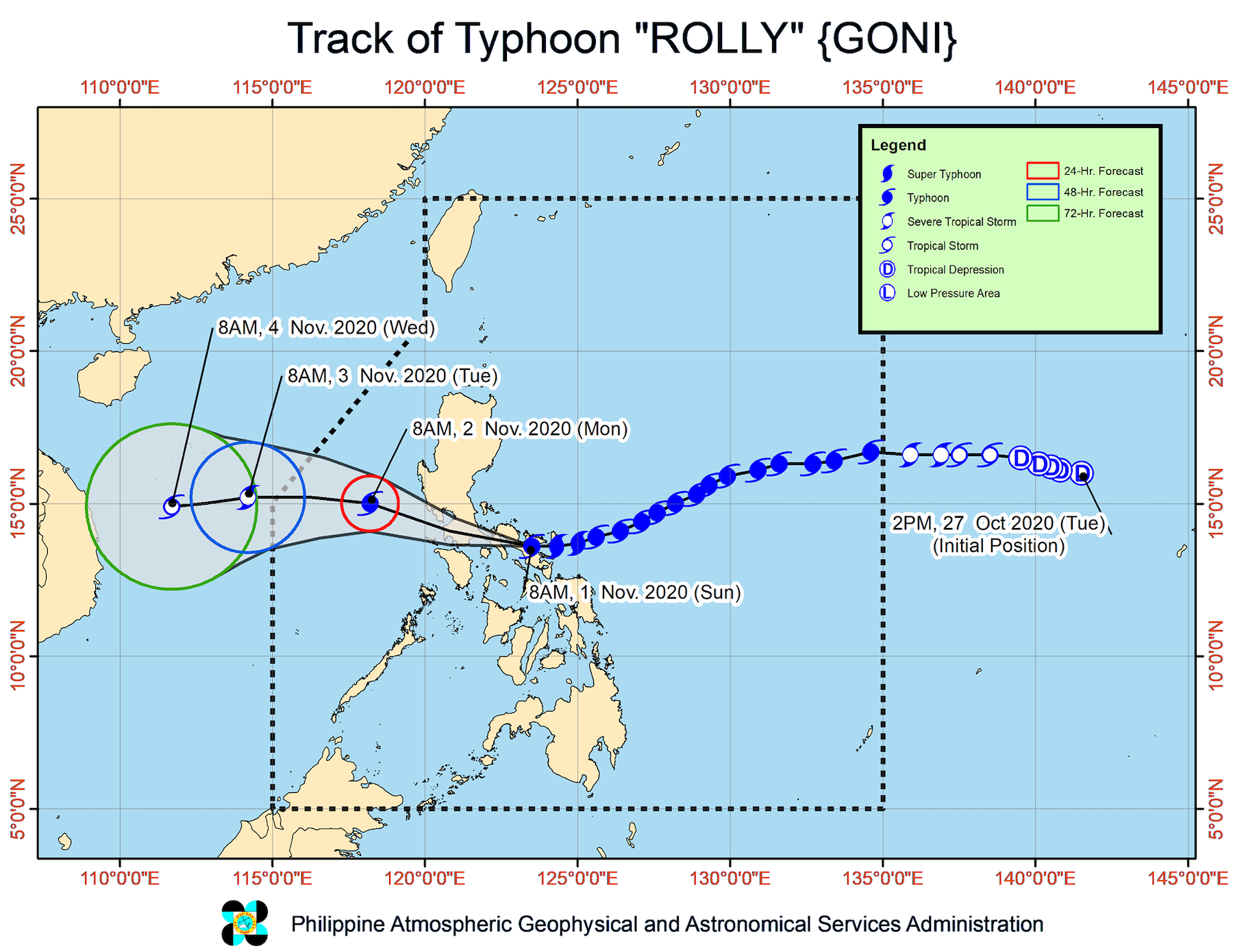
Rolly’s track
On Sunday afternoon, the center of the typhoon will move toward the Marinduque-southern Quezon area, said PAGASA.
Then it will pass over the Batangas-Cavite area late Sunday afternoon until evening. Between 5 pm and 8 pm, the center of Rolly’s eye would be located around 70 kilometers south of Metro Manila.
Rolly is forecast to exit mainland Luzon landmass and emerge over the West Philippine Sea between Sunday night and early Monday morning, November 2.
It may continue to weaken over land, but is still projected to emerge as a typhoon over the West Philippine Sea.
Rolly could leave the Philippine Area of Responsibility (PAR) in the early hours of Tuesday, November 3.
More details to follow. – Rappler.com
Add a comment
How does this make you feel?


There are no comments yet. Add your comment to start the conversation.