SUMMARY
This is AI generated summarization, which may have errors. For context, always refer to the full article.
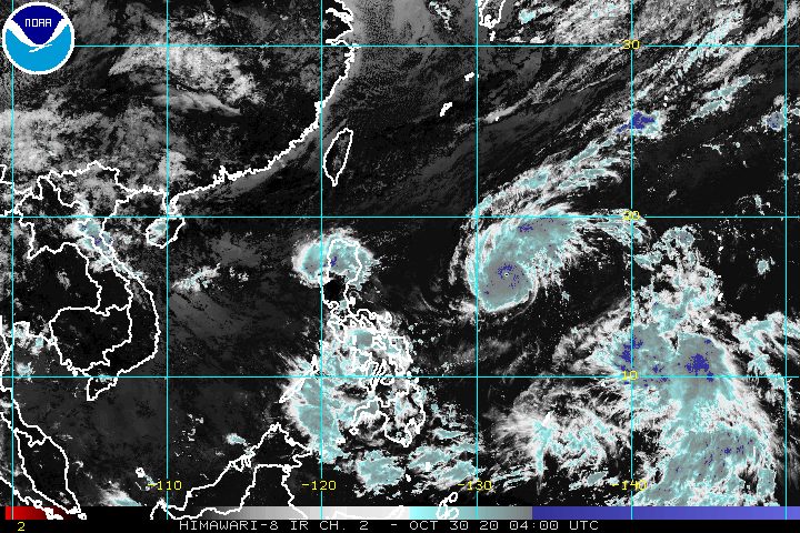
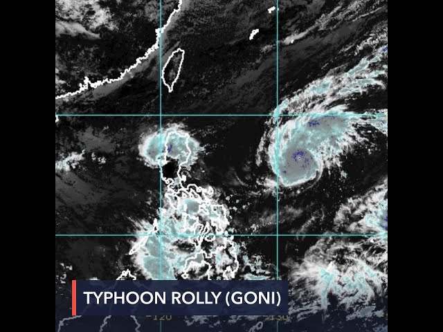
As expected, Typhoon Rolly (Goni) is steadily gaining strength over the Philippine Sea, while moving toward the country.
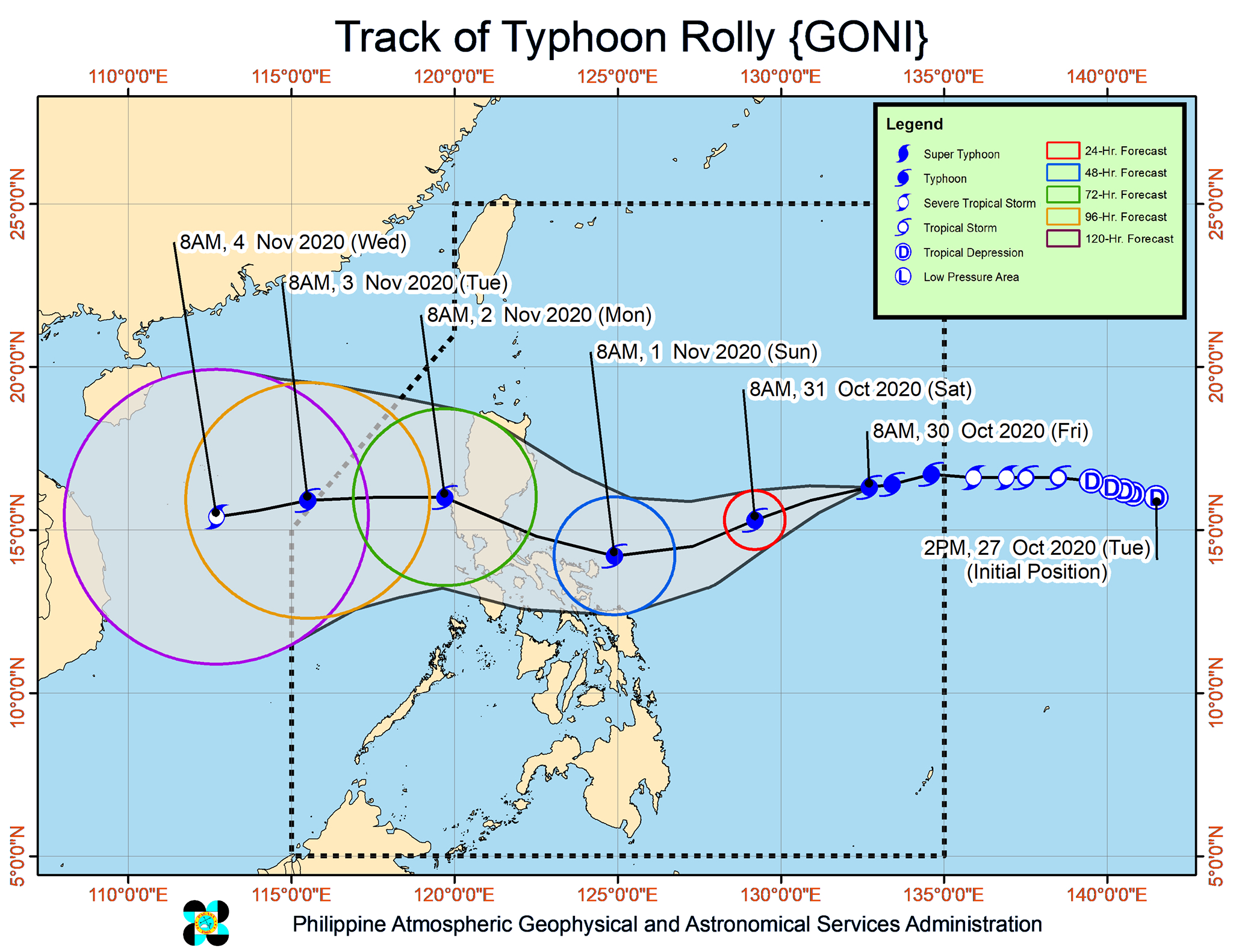
The Philippine Atmospheric, Geophysical, and Astronomical Services Administration (PAGASA) said in an online briefing shortly before noon on Friday, October 30, that Rolly is now 1,100 kilometers east of Central Luzon, still relatively far from land.
The typhoon is moving west at 15 kilometers per hour (km/h) as of Friday morning, slightly slower than its 20 km/h speed before dawn.
It is projected to make landfall either in Aurora or Quezon on Sunday evening, November 1, or early Monday morning, November 2. After that, it would cross Central Luzon, then possibly exit landmass via Pangasinan or Zambales, according to PAGASA Weather Specialist Raymond Ordinario.
“Pag-iingat at paghahanda na ang ating ipinapayo sa lahat dahil nga may panahon pa tayo para maghanda dito nga sa papalapit na bagyong si Rolly,” Ordinario said.
(We advise everyone to take the necessary precautions since we still have time to prepare for the approaching Typhoon Rolly.)
At the moment, Rolly already has maximum sustained winds of 165 km/h and gustiness of up to 205 km/h. This is compared to maximum sustained winds of 140 km/h and gustiness of up to 170 km/h before dawn on Friday.
PAGASA warned that the typhoon will continue to intensify over the Philippine Sea. By the time it makes landfall, it could have a peak intensity of 175 to 185 km/h, referring to its maximum sustained winds.
There are no areas under tropical cyclone wind signals yet. But PAGASA said that “in anticipation of the arrival of strong breeze to near-gale conditions” due to Rolly, Signal No. 1 could be raised over several provinces in the region of Bicol on Friday afternoon.
PAGASA also said the highest possible tropical cyclone wind signal that may be raised would be Signal No. 3 or No. 4. This would mean “destructive to very destructive typhoon-force winds” in areas directly in the typhoon’s path. (READ: FAST FACTS: Tropical cyclones, rainfall advisories)
As for rainfall, Rolly’s trough or extension will start bringing light to heavy rain to the following areas on Friday:
- Bicol
- Visayas
- Caraga
- Northern Mindanao
- Zamboanga Peninsula
Then, as early as Saturday, October 31, there could already be heavy to intense rain in these areas:
- Northern Luzon
- Central Luzon
- Bicol
“Ano’ng mas malakas – ito nga bang dalang hangin o dalang ulan ng bagyong si Rolly? Dahil ito ay isang compact na bagyo…at nagco-concentrate talaga ang lakas nito malapit sa gitna…magkakaroon ito ng malakas na bayo ng hangin at mabigat na buhos ng ulan, so halos pantay ang magiging epekto. Kaya nga pinaghahanda na natin ang ating mga kababayan,” Ordinario said.
(Which is stronger – the winds or the rain from Typhoon Rolly? Because it’s a compact typhoon…and its strength is concentrated near the center…it will bring fierce winds and intense rain, and the effects would be equally damaging. That’s why we’re advising our countrymen to prepare.)
PAGASA issued a gale warning for these areas, where there are rough to very rough seas, with waves 2.8 to 4.5 meters high:
- seaboards of Northern Luzon
- eastern seaboards of Central Luzon and Southern Luzon
It is risky to travel, especially for small vessels, in areas covered by the gale warning.
Meanwhile, moderate to rough seas, with waves 1.2 to 2.5 meters high, will be experienced here:
- remaining seaboards of Luzon
- eastern seaboards of Visayas and Mindanao
For those areas, small vessels must take precautionary measures, while it is not advisable for “inexperienced mariners” to travel, said PAGASA.
Rolly could leave the Philippine Area of Responsibility (PAR) on Tuesday morning, November 3.
PAGASA also continues to keep an eye on Tropical Storm Atsani, located outside PAR at 2,150 kilometers east of Mindanao.
Atsani is moving west northwest at a relatively fast 35 km/h, and could enter PAR on Sunday or Monday. Once it enters, it will be given the local name Siony. (READ: LIST: PAGASA’s names for tropical cyclones in 2020)
So far, the tropical storm has maintained its strength, with maximum sustained winds of 65 km/h and gustiness of up to 80 km/h.
The good news, for now, is that PAGASA said Atsani or the potential Siony is unlikely to bring severe weather to any part of the country over the next 3 days.
Rolly is the Philippines’ 18th tropical cyclone for 2020, while Siony would be the 19th. Rolly is also the 5th tropical cyclone for October alone.
An average of 20 tropical cyclones form within or enter PAR each year.
These are PAGASA’s latest estimates for the number of tropical cyclones inside PAR in the next 6 months:
- November 2020 – 1 to 3
- December 2020 – 2 or 3
- January 2021 – 0 or 1
- February 2021 – 0 or 1
- March 2021 – 0 or 1
- April 2021 – 0 or 1
Last October 2, the state weather bureau warned Filipinos to expect more rain in the coming months due to the onset of La Niña. – Rappler.com
Add a comment
How does this make you feel?


There are no comments yet. Add your comment to start the conversation.