SUMMARY
This is AI generated summarization, which may have errors. For context, always refer to the full article.
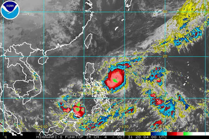
The province of Catanduanes was placed under Signal No. 3 late Saturday morning, October 31, as Typhoon Rolly (Goni) continued to move toward the region of Bicol.
The Philippine Atmospheric, Geophysical, and Astronomical Services Administration (PAGASA) said in a bulletin past 11 am that Rolly is already 480 kilometers east northeast of Virac, Catanduanes.
The typhoon is moving west southwest over the Philippine Sea at the same speed of 20 kilometers per hour (km/h).
So far, Rolly continues to have maximum sustained winds of 215 km/h and gustiness of up to 265 km/h. If its maximum sustained winds exceed 220 km/h, it would be classified as a super typhoon. (READ: FAST FACTS: Tropical cyclones, rainfall advisories)
Here is the latest list of areas where tropical cyclone wind signals are raised as of 11 am on Saturday.
Signal No. 3
- Catanduanes
Signal No. 2
- central and southern parts of Quezon (Mauban, Sampaloc, Lucban, Candelaria, Dolores, Tiaong, San Antonio, Sariaya, Tayabas City, Lucena City, Pagbilao, Atimonan, Padre Burgos, Agdangan, Unisan, Plaridel, Gumaca, Pitogo, Macalelon, General Luna, Catanauan, Mulanay, San Francisco, San Andres, San Narciso, Buenavista, Lopez, Calauag, Guinayangan, Tagkawayan, Quezon, Alabat, Perez) including Polillo Island
- Camarines Norte
- Camarines Sur
- Albay
- Sorsogon
- Burias and Ticao Islands
- Marinduque
- Northern Samar
Signal No. 1
- rest of Masbate
- rest of Quezon
- Rizal
- Laguna
- Cavite
- Batangas
- Romblon
- Occidental Mindoro including Lubang Island
- Oriental Mindoro
- Metro Manila
- Bulacan
- Pampanga
- Bataan
- Zambales
- Tarlac
- Nueva Ecija
- Aurora
- Pangasinan
- La Union
- Benguet
- Ifugao
- Nueva Vizcaya
- Quirino
- southern part of Isabela (Aurora, Luna, Reina Mercedes, Naguilian, Benito Soliven, San Mariano, Palanan, Dinapigue, San Guillermo, Echague, San Agustin, Jones, Cordon, Santiago City, Ramon, San Isidro, Angadanan, Alicia, Cauayan City, Cabatuan, San Mateo)
- northern part of Samar (Tagapul-an, Almagro, Santo Niño, Tarangnan, Catbalogan City, Calbayog City, Santa Margarita, Gandara, Pagsanghan, San Jorge, Jiabong, Motiong, Paranas, San Jose de Buan, Matuguinao)
- northern part of Eastern Samar (Taft, Can-avid, Dolores, Maslog, Jipapad, Arteche, Oras, San Policarpo)
- Biliran
PAGASA warned that destructive typhoon-force winds are expected in Catanduanes since it is now under Signal No. 3. Damaging gale- to storm-force winds will be experienced in areas under Signal No. 2, and strong breeze to near gale conditions in areas under Signal No. 1.
Signal No. 4 remains the highest possible tropical cyclone wind signal that may be raised, for very destructive typhoon-force winds.
PAGASA added that strong breeze to near gale conditions due to the northeasterlies will persist in Batanes, Babuyan Islands, Ilocos Norte, Apayao, and the coastal and mountainous areas of Cagayan and Isabela that are not under a tropical cyclone wind signal.
Meanwhile, in terms of rainfall, the state weather bureau updated its forecast, now saying that intense rain from Rolly will begin early Sunday morning, November 1, instead of late Saturday evening, October 31.
But residents should still prepare ahead, as the forecast could change if, for example, Rolly speeds up. Floods and landslides are possible.
Heavy to intense rain
- Metro Manila
- Bicol
- Calabarzon
- Central Luzon
- Marinduque
- northern parts of Occidental Mindoro and Oriental Mindoro
Moderate to heavy rain
- Cagayan Valley
- Cordillera Administrative Region
- Ilocos Region
- Romblon
- rest of Occidental Mindoro and of Oriental Mindoro
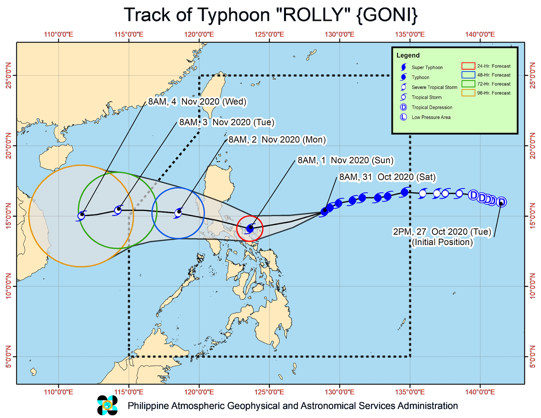
Rolly’s track
PAGASA said the center of the eye of the typhoon is forecast to pass very close to Catanduanes, the Calaguas Islands in Camarines Norte, mainland Camarines Norte, and Camarines Sur on Sunday morning; and then over Quezon province’s Polillo Island and mainland Quezon on Sunday afternoon.
PAGASA said that since Rolly will be going near Bicol, it is not ruling out the possibility of landfall in Catanduanes, Camarines Norte, or Camarines Sur.
Landfall or no landfall, however, “violent winds and intense rainfall” from Rolly’s inner rainband-eyewall region will be experienced in Catanduanes, Camarines Norte, and the northern part of Camarines Sur from early Sunday morning to afternoon, and in Quezon and the southern part of Aurora from Sunday afternoon to evening.
After crossing Central Luzon, the typhoon’s center is forecast to exit mainland Luzon landmass on Monday morning, November 2.
Rolly’s intensity
PAGASA previously said there was a possibility that Rolly could become a super typhoon.
But as of late Saturday morning, it said that Rolly is likely to remain a typhoon, with maximum sustained winds ranging from 185 to 205 km/h, by the time it grazes Bicol and makes landfall over Quezon.
While crossing Luzon, Rolly is seen to “weaken considerably and emerge as a severe tropical storm or minimal typhoon over the West Philippine Sea.”
Coastal conditions
As of late Saturday morning, there remains a “moderate to high risk” of storm surges in the next 48 hours “which may result in life-threatening and damaging coastal inundation.”
- northern coastal areas of Quezon including Polillo Island – up to 3 meters high
- coastal areas of Aurora, Marinduque, Bicol, Northern Samar, and the other coastal areas of Quezon – up to 2 meters high
Storm surges could be “accompanied by swells and breaking waves reaching the coast.”
Travel is also risky for all types of vessels in:
- seaboards of areas under Signal Nos. 1, 2, and 3 – rough to phenomenal seas, with waves 2.5 to 15 meters high
- remaining seaboards of Northern Luzon as well as eastern seaboards of Eastern Visayas that are not under a tropical cyclone wind signal and Caraga – rough to very rough seas, with waves 2.5 to 5 meters high
In the remaining seaboards of the country, there are moderate to rough seas, with waves 1.2 to 2.5 meters high. PAGASA advised those using small vessels to take precautionary measures, while “inexperienced mariners should avoid navigating in these conditions.”
Rolly could leave the Philippine Area of Responsibility (PAR) in the early hours of Tuesday, November 3.
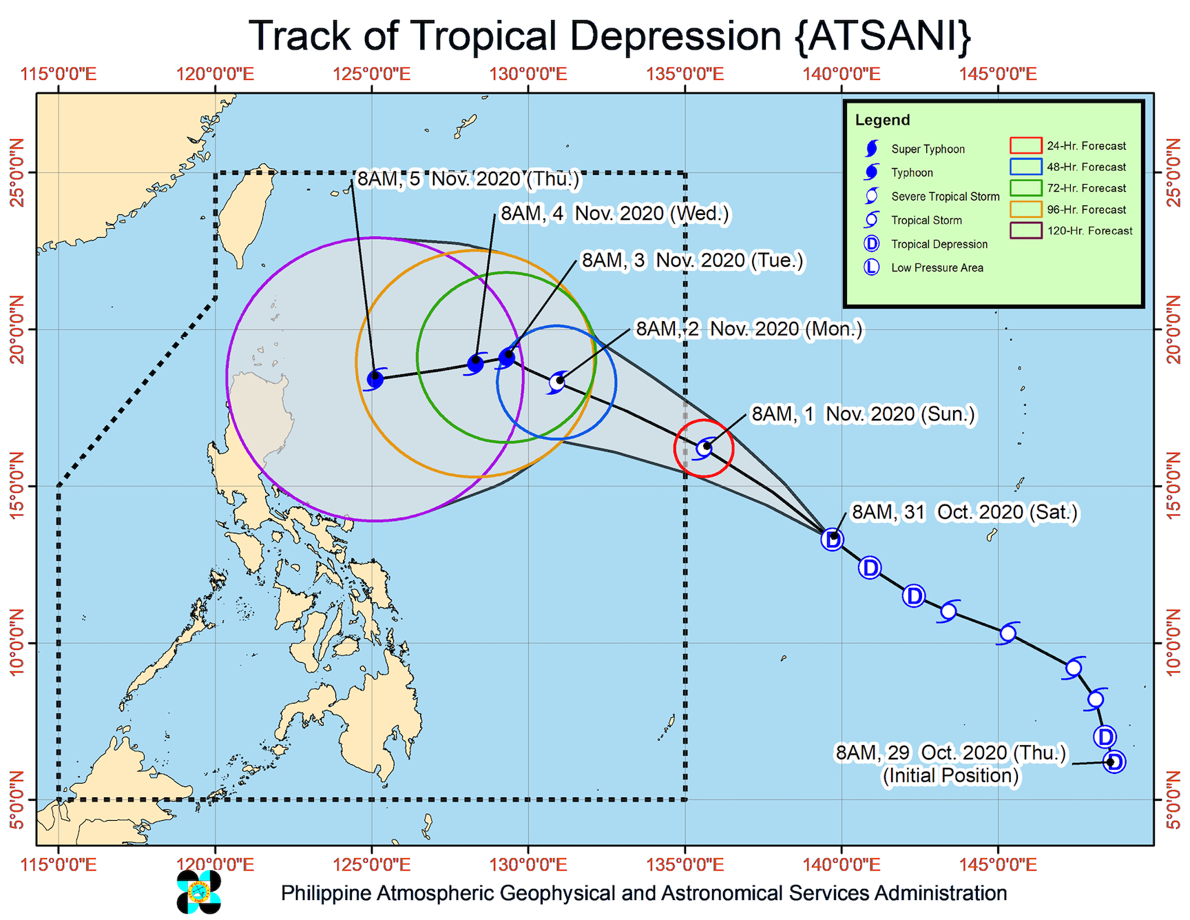
Meanwhile, PAGASA continues to monitor Tropical Depression Atsani, which is located outside PAR at 1,655 kilometers east of Southern Luzon.
The tropical depression is still moving west northwest at 25 km/h, and at this rate, may enter PAR on Sunday afternoon.
Once Atsani enters, it will be given the local name Siony. (READ: LIST: PAGASA’s names for tropical cyclones in 2020)
This means there would be two tropical cyclones inside PAR at the same time, though PAGASA said Atsani “remains less likely to affect any portion of the country over the next 2 to 3 days.”
Atsani continues to have maximum sustained winds of 55 km/h and gustiness of up to 70 km/h as of late Saturday morning. But it is likely to reintensify into a tropical storm in the next 24 hours.
Rolly is the Philippines’ 18th tropical cyclone for 2020, while Siony would be the 19th. Rolly is also the 5th tropical cyclone for October alone.
An average of 20 tropical cyclones form within or enter PAR each year.
These are PAGASA’s latest estimates for the number of tropical cyclones inside PAR in the next 6 months:
- November 2020 – 1 to 3
- December 2020 – 2 or 3
- January 2021 – 0 or 1
- February 2021 – 0 or 1
- March 2021 – 0 or 1
- April 2021 – 0 or 1
Last October 2, the state weather bureau warned Filipinos to expect more rain in the coming months due to the onset of La Niña. – Rappler.com
Add a comment
How does this make you feel?


There are no comments yet. Add your comment to start the conversation.