SUMMARY
This is AI generated summarization, which may have errors. For context, always refer to the full article.
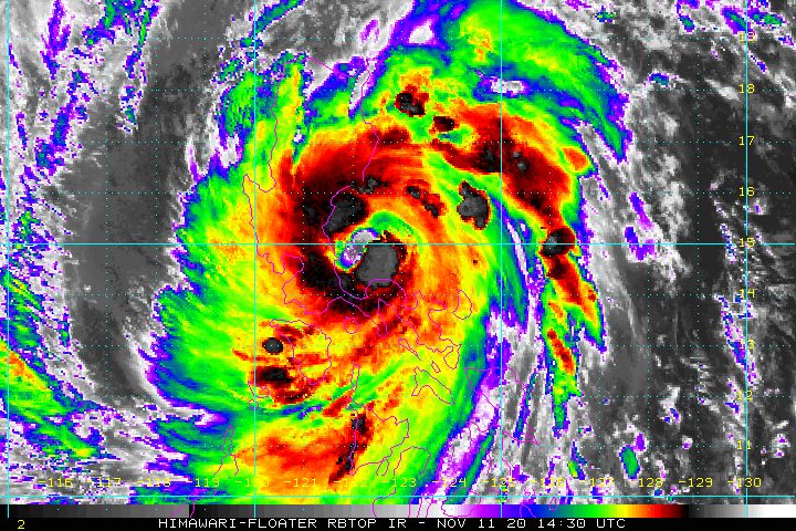
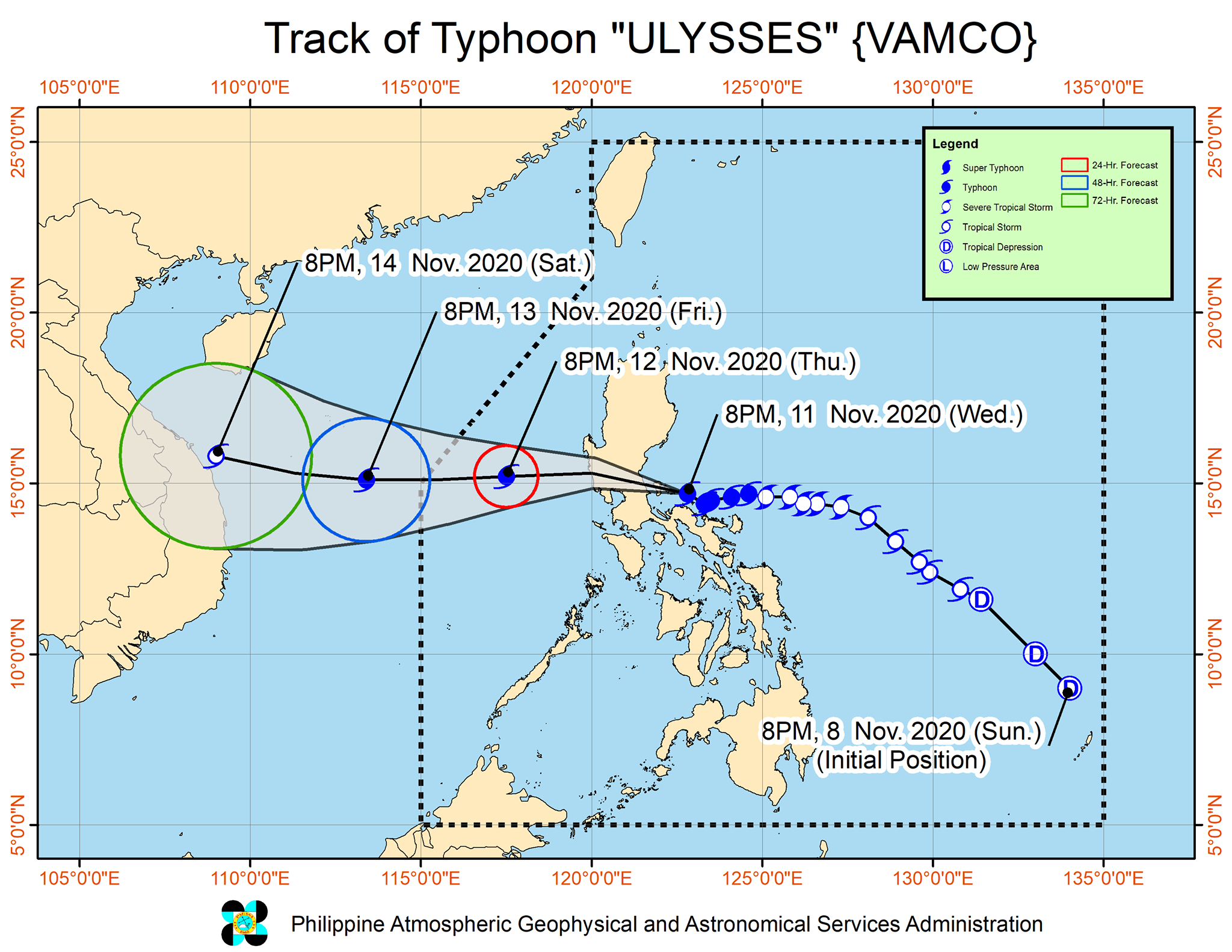
Typhoon Ulysses (Vamco) made its first landfall in Patnanungan, Quezon, at 10:30 pm on Wednesday, November 11.
Ulysses further intensified before hitting land for the first time, too, said the Philippine Atmospheric, Geophysical, and Astronomical Services Administration (PAGASA) in a bulletin released past 11 pm on Wednesday.
The typhoon now has maximum sustained winds of 150 kilometers per hour (km/h) from the previous 140 km/h and gustiness of up to 205 km/h from the previous 195 km/h. (READ: FAST FACTS: Tropical cyclones, rainfall advisories)
Ulysses is moving west northwest at the same pace of 15 km/h.
PAGASA later announced on social media that the typhoon made its second landfall in Burdeos, also in Quezon, at 11:20 pm on Wednesday.
It was still expected to hit mainland northern Quezon, possibly the General Nakar-Infanta area, between 12 am and 3 am on Thursday, November 12. PAGASA said Ulysses is highly likely to hit mainland northern Quezon at peak intensity.
The state weather bureau warned that destructive winds and intense to torrential rain from Ulysses’ eyewall and inner rainbands will be experienced in the following areas within the next 3 hours, or until around 2 am on Thursday:
- central and southern parts of Aurora
- northern and central parts of Quezon including Polillo Island
- western part of Camarines Norte
“Heavy damage to infrastructure and vegetation is expected,” PAGASA said.
After hitting Quezon, Ulysses will cross Central Luzon and emerge over the western seaboard of Zambales on Thursday morning.
PAGASA earlier said the typhoon may be closest to Metro Manila between 4 am and 6 am on Thursday. But late Wednesday evening, the capital region was already experiencing fierce winds and rain.
This is the latest list of areas under tropical cyclone wind signals as of 11 pm on Wednesday:
Signal No. 3 (destructive typhoon-force winds)
- southern part of Quirino (Maddela, Nagtipunan)
- southern part of Nueva Vizcaya (Alfonso Castañeda, Dupax del Norte, Dupax del Sur)
- Pangasinan
- Nueva Ecija
- Aurora
- Tarlac
- Zambales
- Bataan
- Pampanga
- Bulacan
- Metro Manila
- Rizal
- Cavite
- Laguna
- Batangas
- northern and central parts of Quezon (General Nakar, Infanta, Real, Mauban, Sampaloc, Lucban, Tayabas City, Sariaya, Candelaria, Dolores, Tiaong, San Antonio, Lucena City, Pagbilao, Atimonan, Padre Burgos, Unisan, Agdangan, Gumaca, Plaridel, Pitogo, Macalelon, Lopez, General Luna, Catanauan, Buenavista, Guinayangan, Tagkawayan, Calauag, Quezon, Alabat, Perez) including Polillo Island
- Camarines Norte
- northern part of Camarines Sur (Siruma, Cabusao, Libmanan, Sipocot, Lupi, Ragay, Del Gallego, Tinambac, Calabanga, Bombon, Magarao)
Signal No. 2 (damaging gale- to storm-force winds)
- central and southern parts of Isabela (Mallig, Quirino, Ilagan, Roxas, Burgos, Gamu, Palanan, San Mariano, Dinapigue, San Guillermo, Benito Soliven, Naguilian, Reina Mercedes, Luna, San Manuel, Aurora, Cabatuan, Cauayan City, San Mateo, Alicia, Angadanan, Echague, Jones, San Agustin, San Isidro, Ramon, Santiago City, Cordon)
- rest of Quirino
- rest of Nueva Vizcaya
- Mountain Province
- Ifugao
- Benguet
- southern part of Ilocos Sur (Cervantes, Quirino, San Emilio, Lidlidda, Santiago, Banayoyo, Candon City, Galimuyod, Gregorio del Pilar, Salcedo, Santa Lucia, Santa Cruz, Sigay, Suyo, Tagudin, Alilem, Sugpon)
- La Union
- northern part of Occidental Mindoro (Paluan, Abra de Ilog) including Lubang Island
- northern part of Oriental Mindoro (Pola, Victoria, Naujan, Baco, Calapan City, San Teodoro, Puerto Galera)
- Marinduque
- rest of Quezon
- rest of Camarines Sur
- Catanduanes
- Albay
- Burias Island
- northern part of Sorsogon (Sorsogon City, Castilla, Pilar, Donsol)
Signal No. 1 (strong breeze to near gale conditions)
- rest of Isabela
- Kalinga
- Abra
- rest of Ilocos Sur
- rest of Occidental Mindoro
- rest of Oriental Mindoro
- Romblon
- rest of Sorsogon
- central and western parts of Masbate (Palanas, Cawayan, Milagros, Dimasalang, Uson, Mobo, Masbate City, Baleno, Aroroy, Mandaon, Balud) including Ticao Island
- western part of Northern Samar (Lavezares, Biri, San Jose, Rosario, Victoria, San Isidro, Allen, San Antonio, Capul, San Vicente)
In the rest of Northern Luzon, there are strong breeze to gale-force winds due to the surge of the northeast monsoon or hanging amihan.
The state weather bureau also further expanded its rainfall forecast as of 11 pm on Wednesday.
Between Wednesday evening, November 11, and Thursday noon, November 12
Heavy to intense rain, with at times torrential rain
- Camarines Norte
- Camarines Sur
- Metro Manila
- Calabarzon
- Central Luzon
- Quirino
- Nueva Vizcaya
- eastern part of Isabela
Moderate to heavy rain, with at times intense rain
- Cordillera Administrative Region
- rest of mainland Cagayan Valley
- Pangasinan
- Marinduque
- northern part of Occidental Mindoro including Lubang Island
- northern part of Oriental Mindoro
- Albay
- Catanduanes
- Burias Island
Light to moderate rain, with at times heavy rain
- rest of Luzon
- Visayas
Between Thursday noon and late evening, November 12
Heavy to intense rain, with at times torrential rain
- Zambales
- Bataan
- Cavite
- Batangas
- northern part of Occidental Mindoro including Lubang Island
Moderate to heavy rain, with at times intense rain
- Cordillera Administrative Region
- mainland Cagayan Valley
- Babuyan Islands
- Pangasinan
- Tarlac
- Pampanga
- Bulacan
- Metro Manila
- rest of Calabarzon
- rest of Occidental Mindoro
- Oriental Mindoro
- Calamian Islands
Light to moderate rain, with at times heavy rain
- rest of Luzon
- Western Visayas
Floods, landslides, and lahar flows remain threats. Parts of Bicol were already hit by massive floods on Wednesday.
PAGASA said Ulysses could slightly weaken while crossing Central Luzon “due to frictional effects in the presence of the Sierra Madre and Zambales mountain ranges.” But it is likely to remain a typhoon.
There remains a high risk of storm surges which “can cause life-threatening and damaging coastal inundation,” according to the state weather bureau.
Up to 3 meters high
- coastal areas of Aurora, Quezon including Polillo Island, and Camarines Norte
Up to 2 meters high
- coastal areas of Isabela, La Union, Zambales, Bataan, Pampanga, Bulacan, Metro Manila, Cavite, Batangas, northern parts of Oriental Mindoro and Occidental Mindoro including Lubang Island, Marinduque, Romblon, Masbate including Ticao and Burias Islands, Catanduanes, Camarines Sur, Albay, and Sorsogon
“Moreover, there is also a moderate risk of seiche or storm surge over the coastal areas surrounding Laguna de Bay,” PAGASA said.
Within the next 24 hours, Ulysses and the surge of the northeast monsoon combined will make travel risky for all types of vessels in certain seaboards.
Rough to very high seas (waves 2.5 to 11 meters high)
- seaboards of areas under Signal Nos. 1, 2, and 3
- northern seaboard of Northern Samar
Rough to high seas (waves 3 to 6 meters high)
- remaining seaboards of Northern Luzon
Rough to very rough seas (waves 2.5 to 4.5 meters high)
- western seaboard of Palawan including Calamian and Kalayaan Islands
Meanwhile, waters are moderate to rough, with waves 1.5 to 2.5 meters high in the seaboards below. Small vessels must take precautionary measures.
- eastern seaboards of Visayas and Mindanao
- seaboards of Cuyo Islands
- western seaboard of Panay Island
Ulysses could exit the Philippine Area of Responsibility (PAR) on Friday morning or afternoon, November 13.
Ulysses is the Philippines’ 21st tropical cyclone for 2020 – already above the yearly average of 20. (READ: LIST: PAGASA’s names for tropical cyclones in 2020)
For the next 6 months, these are PAGASA’s estimates for tropical cyclones inside PAR:
- November 2020 – 1 to 3
- December 2020 – 2 or 3
- January 2021 – 0 or 1
- February 2021 – 0 or 1
- March 2021 – 0 or 1
- April 2021 – 0 or 1
Since October, La Niña has been underway, which means there is more rain than usual.
Then in November, the northeast monsoon began, signaling “surges of cold temperatures.”
PAGASA warned that La Niña may enhance the northeast monsoon, which could trigger floods and landslides. – Rappler.com
Add a comment
How does this make you feel?


There are no comments yet. Add your comment to start the conversation.