SUMMARY
This is AI generated summarization, which may have errors. For context, always refer to the full article.
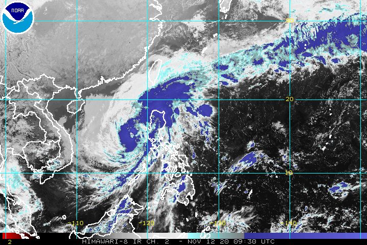
The only remaining tropical cyclone wind signal is Signal No. 1, with Typhoon Ulysses (Vamco) moving away from Luzon and slightly weakening on Thursday afternoon, November 12.
In a press briefing past 5 pm on Thursday, the Philippine Atmospheric, Geophysical, and Astronomical Services Administration (PAGASA) said Ulysses is now 200 kilometers west of Iba, Zambales.
The typhoon is moving west at 25 kilometers per hour (km/h), and may exit the Philippine Area of Responsibility (PAR) on Friday morning, November 13. (READ: FAST FACTS: Tropical cyclones, rainfall advisories)
Its maximum sustained winds are down to 120 km/h, while it has gustiness of up to 150 km/h. When Ulysses first made landfall late Wednesday evening, November 11, it had maximum sustained winds of 150 km/h.
Below are the areas left under Signal No. 1 as of 5 pm on Thursday. They may still experience strong breeze to near gale conditions.
- western part of Pangasinan (Bautista, Alcala, Malasiqui, Santo Tomas, Santa Barbara, Mapandan, Mangaldan, Dagupan City, Calasiao, San Carlos City, Basista, Bayambang, Urbiztondo, Mangatarem, Aguilar, Binmaley, Lingayen, Bugallon, Labrador, Infanta, Mabini, Dasol, Sual, Alaminos City, Burgos, Agno, Bani, Bolinao, Anda)
- Tarlac
- western part of Pampanga (Magalang, Mabalacat, Angeles City, Porac, Floridablanca, Arayat, Mexico, Santa Ana, San Fernando City, Bacolor, Santa Rita, Guagua, Lubao, Sasmuan)
- Zambales
- Bataan
- Lubang Island
The highest tropical cyclone wind signal raised due to Ulysses was Signal No. 3.
In Northern Luzon, there are strong breeze to gale-force winds due to the surge of the northeast monsoon or hanging amihan.
The threat of more floods, landslides, and lahar flows from Ulysses is not completely gone yet, as rain from the typhoon will persist on Thursday evening.
Moderate to heavy rain
- Cordillera Administrative Region
- eastern part of Cagayan
- eastern part of Isabela
- Zambales
- Bataan
- Aurora
- Cavite
- western part of Batangas
- Occidental Mindoro including Lubang Island
Light to moderate rain, with at times heavy rain
- rest of Luzon
- Western Visayas
- Samar
- Eastern Samar
- Northern Samar
Within the next 24 hours, travel for all types of vessels in certain seaboards will stay risky due to Ulysses and the surge of the northeast monsoon combined.
Rough to very rough seas (waves 2.5 to 6 meters high)
- seaboards of areas under Signal No. 1, Northern Luzon, and Occidental Mindoro
- western seaboards of Batangas and Palawan including Calamian and Kalayaan Islands
Meanwhile, PAGASA said small vessels should take precautionary measures in the seaboards below.
Moderate to rough seas (waves 1.5 to 2.5 meters high)
- eastern seaboards of Central Luzon, Southern Luzon, Visayas, and Mindanao
- seaboards of Cuyo Islands
- western seaboard of Panay Island
There is no more storm surge warning in effect as of 5 pm on Thursday.
Ulysses first passed very close to Bicol on Wednesday, causing massive floods in the region. The Office of Civil Defense Region V said on Thursday that at least 2 persons died, 4 are missing, and 8 others injured due to Ulysses, all from Camarines Norte.
The typhoon then made landfall thrice in Quezon province:
- Patnanungan – 10:30 pm on Wednesday, November 11
- Burdeos – 11:20 pm on Wednesday, November 11
- General Nakar – 1:40 am on Thursday, November 12
After hitting Quezon, Ulysses crossed Central Luzon. Nearby regions Metro Manila and Calabarzon also felt the wrath of the typhoon. (READ: #ReliefPH: Help communities recover from Typhoon Ulysses)
In Marikina City, as the Marikina River’s water level rose, residents were reminded of the deadly onslaught of Tropical Storm Ondoy (Ketsana) in September 2009. (READ: Air rescue needed: Thousands of Marikina houses submerged in roof-level floods)
Rizal province was also badly affected, with residents fleeing their homes due to rising floods.
Classes are suspended in parts of Luzon for Friday, as floods have yet to subside in some areas and cleanup operations continue for others. Power and communication lines have also yet to be fully restored.
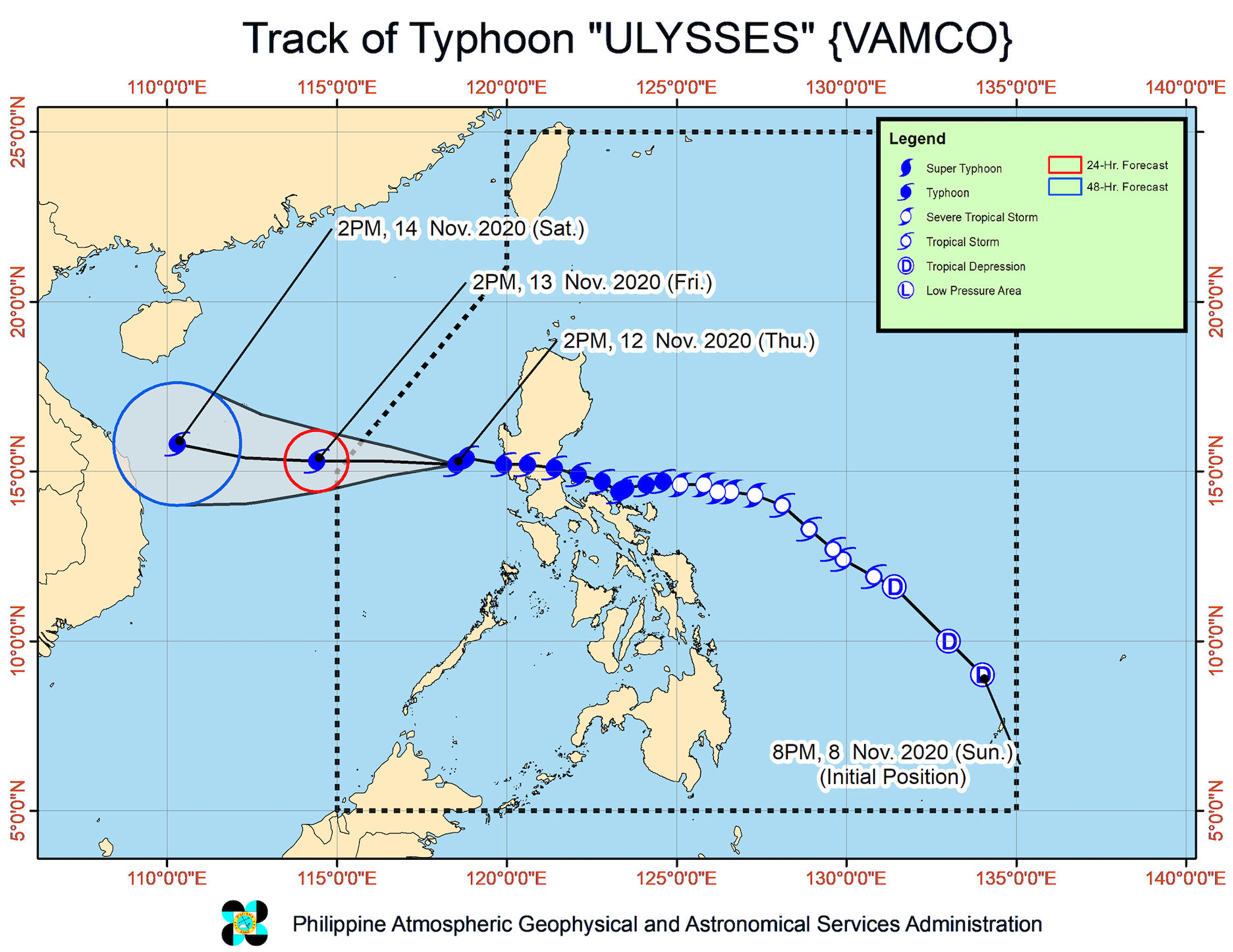
Ulysses is the Philippines’ 21st tropical cyclone for 2020 – already above the yearly average of 20 – and the 3rd for November. (READ: LIST: PAGASA’s names for tropical cyclones in 2020)
For the next 6 months, these are PAGASA’s estimates for tropical cyclones inside PAR:
- November 2020 – 1 to 3
- December 2020 – 2 or 3
- January 2021 – 0 or 1
- February 2021 – 0 or 1
- March 2021 – 0 or 1
- April 2021 – 0 or 1
Since October, La Niña has been underway, which means there is more rain than usual.
Then in November, the northeast monsoon began, signaling “surges of cold temperatures.”
PAGASA warned that La Niña may enhance the northeast monsoon, which could trigger floods and landslides. – Rappler.com
Add a comment
How does this make you feel?


There are no comments yet. Add your comment to start the conversation.