SUMMARY
This is AI generated summarization, which may have errors. For context, always refer to the full article.
MANILA, Philippines – All eyes are on Taal Volcano as it continues to spew ash, prompting massive evacuation in nearby areas.
On Sunday, January 12, it was placed on Alert Level 4, which warns of a “hazardous” eruption that could happen “within hours to days.” (READ: Taal Volcano alert levels)
Situated in Batangas, Taal Volcano has been a staple tourist destination for many, given its proximity to Metro Manila and other nearby areas. What else do we need to know about Taal Volcano?
How big is Taal Volcano?
The Philippine Institute of Volcanology and Seismology (Phivolcs) classifies Taal Volcano as a complex volcano system.
It has 47 craters and 4 maars (volcanic craters caused by an eruption occurring when old groundwater is in contact with hot rock or magma). The main crater lake, located on Volcano Island, is 1.9 kilometer in diameter.
Volcano Island, where many of the past eruptions occurred, lies in the middle of Taal Lake.
Taal Volcano’s rock type is classified as olivine basalt, a type of mineral, and andesite, a type of rock formed through the cooling of lava or magma. It is part of the the Macolod Corridor – an estimated 40-kilometer-wide zone of active volcanic activity in Luzon. It is estimated to be 311 meters high.
How active is Taal Volcano?
Taal Volcano is one of the country’s 24 active volcanoes. Although it hasn’t erupted since 1977, it is still classified as one of the world’s lowest and deadliest volcanoes.
In fact, authorities had recorded volcanic unrest in 2011, 2012, and 2014.
How many eruptions in history?
A total of 34 eruptions have been recorded within 448 years with varying characteristics – phreatic and phreatomagmatic (involving the interaction of magma and water) and strombolian (characterized by rising bubbles formed by the fusion of gas inside), among others. (FAST FACTS: Phreatic and other types of volcanic eruption)
The first recorded was in 1572 when a phreatomagmatic eruption occurred at the main crater of the volcano. Its biggest eruption, meanwhile, was recorded in 1754 which lasted for 7 months between May and December. (TIMELINE: Taal Volcano eruptions since 1572)
The Taal Volcano 1754 eruption buried 4 Batangas towns under ash, volcanic rocks, and water, while ashfall deposits were recorded to have reached 100 to 110 centimeters. (READ: Taal 1754 eruption: Will history repeat itself?)
The latest eruptions before the 2020 explosion occurred in the 1970s and all took place at the Mt Tabaro crater.
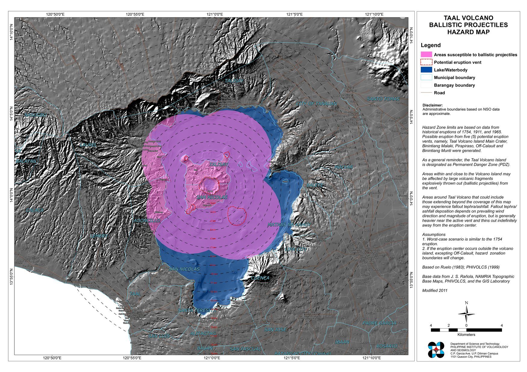
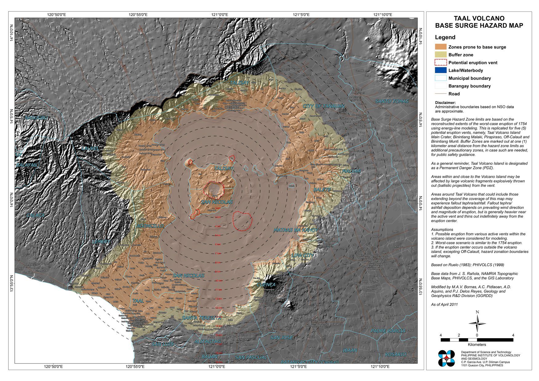
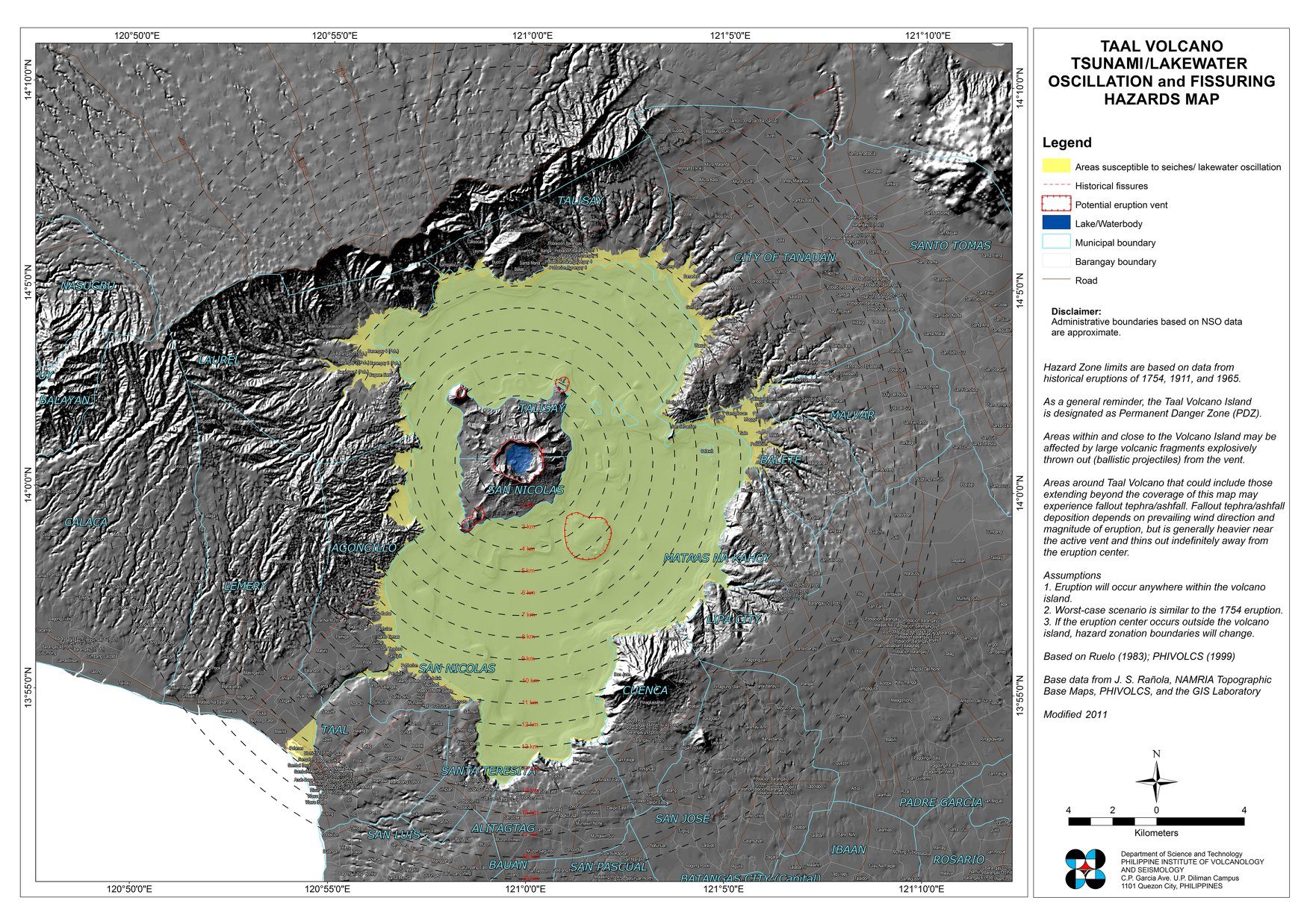
What are the type of hazards?
According to Phivolcs, Taal Volcano’s hazards include:
- Base surges or clouds of hot gases, ash, and rocks traveling horizontally at speeds of more than 80 kilometers per hour
- Seiches or lake water oscillation or explosions and earthquakes accompanying the eruption
- Ashfall and volcanic rock fragments
- Lava flow (hot molten rocks)
- Strong earthquakes
Phivolcs has tagged the entire volcano island as a permanent danger zone while buffer zones cover several lakeshore barangays in Talisay, Agoncillo, San Nicolas, and Laurel in Batangas province.
To prevent risks and damage, Phivolcs developed maps that show possible areas affected by each indicated hazard. The maps are based on information recorded during the 1754 eruption.
What should the public do now?
Authorities have advised the public to remain vigilant as the alert level on Taal Volcano continues to rise. It remains at Alert Level 4.
The Batangas PDRRMC estimated that up to 200,000 people could be affected in the event of a major eruption.
Thousands of residents have fled towns near Taal Volcano. According to the National Disaster Risk Reduction and Management Council, at least 6,000 people have evacuated.
Ashfall, meanwhile, has been reported in several areas outside Batangas, including Metro Manila.
The Department of Health warned of potential health effects of ashfall. It urged people to stay indoors. For those who need to step out, wearing masks (particularly the N95 kind) is highly recommended. (READ: How to stay safe during volcanic ashfall) – with reports from Pia Ranada and Pauline Macaraeg/Rappler.com
Read Rappler explainers on Taal Volcano:
Add a comment
How does this make you feel?
There are no comments yet. Add your comment to start the conversation.