SUMMARY
This is AI generated summarization, which may have errors. For context, always refer to the full article.
MANILA, Philippines – Super Typhoon Yolanda (international codename Haiyan), possibly the strongest typhoon to ever make landfall in recent history, left a trail of death and destruction in its wake.
With reports slowly trickling in from the typhoon zone, Eastern Visayas is emerging as the worst-hit area.
The region isn’t a stranger to typhoons, but this particular system has brought unimaginable devastation to an already impoverished region.
Here are some facts about Eastern Visayas:
Terrain
Eastern Visayas is located on the eastern edge of the Visayas island chain, facing the Pacific Ocean. The islands of Samar, Leyte, and Biliran are the main land masses. It covers an area of 21,562.9 square kilometers (2.15 million hectares).
According to the regional office of the National Economic and Development Authority (NEDA), the region’s terrain is relatively flat near and along the coasts, with the mountainous areas mostly located in the middle portion of Samar and Leyte islands.
The southern and southwestern portions of Leyte are mountainous, while its northern portion is extensively flat. Samar, on the other hand, has a lot of mountainous ranges with forest and deep valleys.
Around 52.2% of the region is forest land.
Political divisions
Officially known as Region VIII, Eastern Visayas has 6 provinces, 12 districts, 7 cities, 136 municipalities, and 4,390 barangays.
- Biliran (capital Naval): lone district, 8 municipalities, 132 barangays
- Eastern Samar (capital Borongan City): lone district, 22 municipalities, 1 city, 597 barangays
- Leyte (capital Tacloban City): 5 districts, 40 municipalities, 3 cities, 1,641 barangays
- Northern Samar (capital Catarman): 2 districts, 24 municipalities, 569 barangays
- Samar (formerly Western Samar) (capital Catbalogan City): 2 districts, 24 municipalities, 2 cities, 951 barangays
- Southern Leyte (capital Maasin City): lone district, 18 municipalities, 1 city, 500 barangays
Tacloban City is the region’s administrative center.
Population
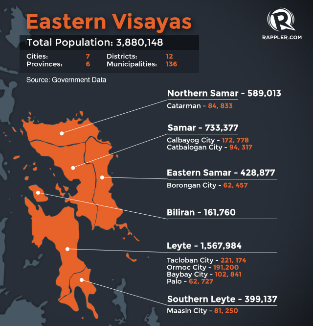
Based on the 2010 census, Eastern Visayas has a total population of 3,880,148. The population for each province is as follows:
- Biliran – 161,760
- Eastern Samar – 428,877
- Leyte – 1,567,984
- Northern Samar – 589,013
- Samar – 733,377
- Southern Leyte – 399,137
Most of the people live in the following cities and towns:
- Tacloban City (Leyte) – 221,174
- Ormoc City (Leyte) – 191,200
- Calbayog City (Samar) – 172,778
- Baybay City (Leyte) – 102,841
- Catbalogan City (Samar) – 94,317
- Catarman (Northern Samar) – 84,833
- Maasin City (Southern Leyte) – 81,250
- Palo (Leyte) – 62,727
- Borongan City (Eastern Samar) – 62,457
- Laoang (Northern Samar) – 58,037
Politics
The following are the officials of each province and district of the region, all elected in this year’s midterm elections:
Governors:
- Gerardo Espina Jr. – Biliran
- Conrado Nicart Jr. – Eastern Samar
- Leopoldo Dominico Petilla – Leyte
- Jose Ong Jr. – Northern Samar
- Sharee Ann Tan – Samar
- Roger Mercado – Southern Samar
Congressmen:
- Rogelio Espina – Biliran, lone district
- Ben Evardone – Eastern Samar, lone district
- Ferdinand Martin Romualdez – Leyte, 1st district
- Sergio Apostol – Leyte, 2nd district
- Andres Salvacion – Leyte, 3rd district
- Lucy Torres-Gomez – Leyte, 4th district
- Jose Carlos Cari – Leyte, 5th district
- Raul Daza – Northern Samar, 1st district
- Emil Ong – Northern Samar, 2nd district
- Mel Senen Sarmiento – Samar, 1st district
- Milagrosa Tan – Samar, 2nd district
- Damian Mercado – Southern Leyte, lone district
Poverty
Eastern Visayas registers the 3rd highest percentage of poverty incidence among families in 2012, at 37.2%. Percentage per province are:
| Province | Per Capita Poverty Threshold (PhP), 2012 | Poverty Incidence among Families (%), 2012 |
|---|---|---|
| Biliran | 8553 | 20.7 |
| Eastern Samar | 10054 | 59.4 |
| Leyte | 8593 | 31.9 |
| Northern Samar | 9511 | 43.7 |
| Samar (Western Samar) | 7881 | 36 |
| Southern Leyte | 9805 | 36.4 |
Economy
The Department of Agriculture’s 2011 report said agriculture, fishery and forestry accounted for 20.49% of the regional economy.
In that year, palay and coconut were the leading commodities to agricultural production of Eastern Visayas. The region was 7th in palay production and 2nd in coconut production.
The agricultural land area in Eastern Visayas covers 723,048 hectares, or 31% of the region’s total land area of 2,325,395 hectares.
In the agency’s September report, low volume of fish catch and limited supply of fishery products were noted due to expensive fishing trips and rough seas.
Disaster preparedness
In September, the Department of Public Works and Highways reactivated its “Quick Response Team,” which will focus on monitoring flood-prone areas and to undertake clearing of roads from debris, and emergency opening of damaged roads due to slips/slides to at least one lane for regular traffic to pass. – Reynaldo Santos Jr. / Rappler.com
Help the victims of Typhoon Yolanda (international codename: Haiyan). Visit Rappler’s list of ongoing relief operations in your area. Tell us about your relief and recovery initiatives, emailmove.ph@rappler.com or tweet us @moveph.
Visit rappler.com/typhoon-yolanda for the latest updates on Typhoon Yolanda.
More from our coverage:
- #ReliefPH: Victims of Typhoon Yolanda need your help
- Iloilo under state of calamity
- President’s ‘pork,’ savings to fund Yolanda relief efforts
- Tacloban hospital faces medicine shortage
- Land route from Manila to Tacloban now passable – Roxas
- Worried Pinoys use social media to find loved ones
- Tacloban Diary: I saw death, I fear anarchy
- TIMELINE: Super Typhoon Yolanda
- WRAP: Hundreds feared dead as Yolanda exits PH
Add a comment
How does this make you feel?
There are no comments yet. Add your comment to start the conversation.