SUMMARY
This is AI generated summarization, which may have errors. For context, always refer to the full article.
MEDAN, Indonesia – Indonesia and the Philippines are now moving forward with open-access disaster-risk information systems to face possible disasters in the future.
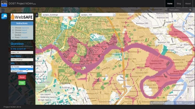
The Philippines’ Project NOAH (Nationwide Operational Assessment of Hazards), has recently launched WebSAFE, a new tool that produces hazard impact scenario maps including visualizations on the possible extent of a disaster and its impact on human population in affected areas.
WebSAFE is a software that analyzes the impact of disasters based on available hazard and infrastructure maps. It is adapted from Indonesia’s software INASAFE and was a part of collaboration with World Bank’s Global Facility for Disaster Reduction and Recovery (GFDRR).
But unlike INASAFE, which is only used by officials in Indonesian National Board for Disaster Management (BNPB), WebSAFE will be incorporated in Project NOAH website within July for everyone to access the information. It will allow people to know hazards around them and give them ideas on how to prepare for possible disasters.
Dr. Mahar Lagmay, Executive Director of Project NOAH, said that WebSAFE will not only be important during emergencies.
“We need to incorporate [WebSAFE] in our website. The goal is to let each local government unit have access to it (so) they will be able to know what they need (to do) during disasters. And this is not just for emergency and imminent danger only. It can also be used for land use planning and zoning,” said Lagmay.
INASAFE or WebSAFE is just one of the tools that both countries have been using to make disaster risk information available to the public. Aside from WEBSAFE, Project NOAH is also using LiDAR equipment, a technology that uses light planes to map flood prone areas in 3D image under the DREAM-LiDAR (Disaster Risk Exposure Assessment for Mitigation – Light Detection and Ranging) Project.
LiDAR technology is capable of simultaneous land and water mapping through 3D imagery at a very rapid rate. It is also considered to be the most effective technique for flood hazard mapping.
Indonesia, as a country that is also regularly hit by disasters, took one more step forward in developing an open-access disaster-risk information system. Agus Wibowo, the Data Head of the Geospatial Division in the BNPB, told Rappler that Indonesia has moved to crowdsourced data mapping for disaster management.
Wibowo mentioned Sijampang, an open-source Android application which is developed by Indonesia’s Agency for the Development and Assessment of Technology (BPPT) to inform people about the rain and floods occurrence in Indonesia.
“Sijampang allows users to get any information about rain and flood occurrence in Jakarta. At the same time, users can also send information if they see rain in their areas. Their informations are then included to Sijampang maps,” said Wibowo.
Dr. Firman Hadi, geospatial scientist from Bandung Institute of Technology in Indonesia, added that there is still a challenge with this disaster-risk information system. Hadi mentioned while the use of satellite imagery to map disaster-prone areas is a step forward, he highlighted unpredictable weather as a problem.
“When the flood happens in rainy season, satellite could not produce image because there are more clouds in the atmosphere,” Hadi said. – Rappler.com
Add a comment
How does this make you feel?
There are no comments yet. Add your comment to start the conversation.