SUMMARY
This is AI generated summarization, which may have errors. For context, always refer to the full article.
 How high can you go? The peak of Mt Apo, the highest mountain in the country, towers at 2,954 meters (almost 3 km) above sea level, and overlooks Davao City to the northeast, Digos City to the southeast, and Kidapawan City to the west.
The view from the top must be breathtaking. I’ve been told that there is a climbing trail easy enough for first-timers, and this is definitely on my bucket list! For now, let’s conquer this mountain in a different way.
Imagine taking a gigantic knife and cutting the mountain in half, slicing all the way through the island of Mindanao and its surrounding bodies of water. What would you get? Something like this:
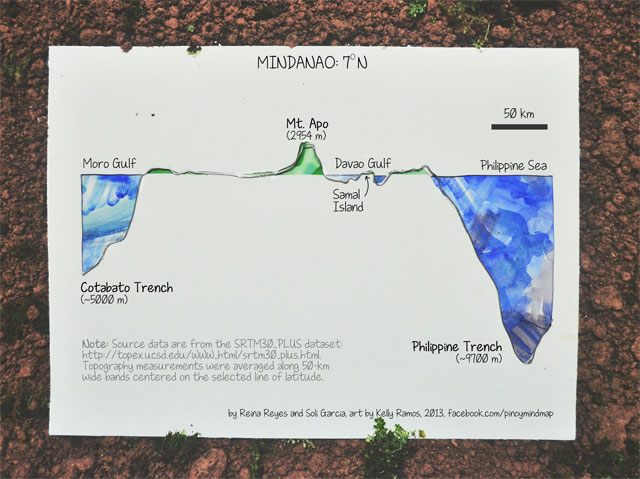
For this piece, Kelly has carefully shaped an ordinary steel wire to trace topography measurements extracted by our geophysicist friend, Soli, from the SRTM30_PLUS dataset (which combines land data from the NASA Shuttle Radar Topography Mission (SRTM) with ocean data from several satellite-based and shipboard bathymetry surveys).
This slice through the Philippines, centered at a latitude of 7 degrees North, crosses through Mt. Apo, 4 provinces (Maguindanao, Cotabato, Davao del Sur, and Davao Oriental), 3 major bodies of water (Moro Gulf, Davao Gulf, and the Philippine Sea) and a small island (Samal in the middle of the Davao Gulf!). From end to end, it covers a distance of around 400 km (note the 50 km scale bar at the upper right hand corner). (Astute readers can further note that the horizontal scale here is around 11 times larger than the vertical scale.)
The cone of Mt Apo indeed rises to an impressive height above the surrounding land. Yet its majesty is dwarfed by the sheer size of the deep-sea trenches looming underneath, just a few hundred kilometers away on either side. To the West, the Cotabato Trench under the Moro Gulf reaches an average depth of 5,000 meters at this latitude. To the East, the Philippine Trench under the Philippine Sea — one of the deepest trenches in the world — reaches almost twice as deep, with an average depth of 9,700 meters (and over 10,000 meters at its deepest point).
If Mt Apo were to be planted at the bottom of the ocean floor on the Cotabato Trench, its peak would reach about halfway to the surface — and only a third of the way up for the Philippine Trench! That we find these extremes of highs and lows in such close proximity is not a coincidence, but is a sign of the dynamic geological activity that has slowly but dramatically shaped our archipelago over millions of years.
In particular, the process that caused the formation of the Philippine Trench — the subduction of the Philippine Sea Plate underneath the Philippine Mobile Belt — has also created ideal conditions for the formation of volcanoes inland — giving rise to Mt Apo! Although there is no record of any eruptions (within the past 600 years), Mt Apo is classified as a young stratovolcano, and Phivolcs lists it as potentially active.
Mt Kanlaon, the highest mountain in the Visayas, is an active volcano formed by a similar process — in this case, the subduction of the Southeast Sulu Sea Basin under the Philippine Mobile Belt — that formed the Negros Trench west of the Visayas. Here is what a slice through Mt Kanlaon looks like:
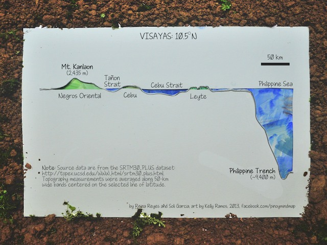
From west to east, we cut through the Tañon Strait between Negros island and Cebu, then Cebu Strait between Cebu and Leyte. Off to the east, we again encounter the Philippine Trench, here just slightly shallower, with an average depth of 9,400 meters — still deep enough to engulf the equivalent of 3 Mt Kanlaon’s!
Finally, let’s take a slice through Mt Pulag, the highest mountain in Luzon, and the third highest in the country* at 2,922 meters high.
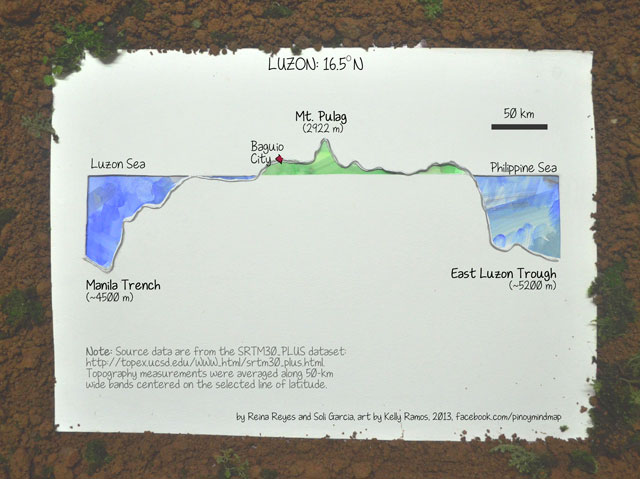
Notice that Mt Pulag itself rests on the Cordillera highlands, and next to it we find a couple of other peaks within the Cordillera Central mountain range. Off the west coast of Luzon, we find the Manila Trench under the Luzon Sea, and off the east coast is the East Luzon Trough under the Philippine Sea. These trenches are much shallower than their southern counterparts, but are still deep enough to fully submerge all of the Cordillera mountains.
Unlike Mt Apo and Mt Kanlaon, Mt Pulag is not volcanic in origin. In fact, the rocks that comprise Mt Pulag and much of the Cordillera highlands used to be deep underwater! They were gradually raised to the elevation we find today over millions of years of tectonic uplift. It is thought that Luzon is also surrounded by subduction on both sides, like Visayas and Mindanao, but the nature of this process is less well understood.
Indeed, as we have glimpsed here, the Philippines is remarkably rich in interestingly complex geological phenomena that invite — and deserve — further study. A better understanding of these processes would not only help better explain our country’s extreme highs and lows, but would also aid in delineating the natural hazards — volcano eruptions, earthquakes, tsunamis — that they, unfortunately, but inevitably, give rise to. – Rappler.com
‘Pinoy Mind Map’ is a collaboration between scientist Reina Reyes and artist Kelly Ramos. They embrace their geekiness and artsiness, respectively, and combine them to produce data art pieces inspired by the Filipino experience. They can be reached at the blog’s Facebook page: facebook.com/pinoymindmap.
Soli Garcia is currently pursuing a Ph.D. in Earth Sciences at the Scripps Institution for Oceanography, University of California, San Diego.
*Editor’s Note: An earlier graphic showed the height of Mt Kanlaon as 2,954 m. The graphic has been replaced to reflect Kanlaon’s actual height, 2,435 m. In addition, Mt. Dulang-dulang is the second highest mountain in the country, beating Mt. Pulag by 16 m (about two stories high) at 2,938 m. We earlier said Pulag is the second highest. Thanks for the readers who pointed it out!
Add a comment
How does this make you feel?
There are no comments yet. Add your comment to start the conversation.