SUMMARY
This is AI generated summarization, which may have errors. For context, always refer to the full article.
![[OPINION] How Natib volcano and her 2 sisters came to be](https://www.rappler.com/tachyon/2021/06/tl-natib-volcano-SQ.jpg)
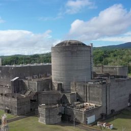
The following is the eighth in a series of excerpts from Kelvin Rodolfo’s ongoing book project Tilting at the Monster of Morong: Forays Against the Bataan Nuclear Power Plant and Global Nuclear Energy.
If you don’t know much geology, to understand why Mount Natib and her sister volcanoes exist, and how the Bataan Nuclear Power Plant (BNPP) can be devastated by “reverse faulting” or tsunamis, requires a serious stretch of the imagination. The greatest demand made on people new to geology is to start thinking in terms of very slow processes, operating centimeters or inches per year, accomplishing enormous feats over tens or hundreds of millions of years: raising a deep-sea floor into great mountain chains, cracking continents into pieces that move thousands of miles apart as new ocean basins grow between them; destroying entire ocean basins elsewhere.
Plate tectonics theory
Earth’s rocky crust is underlain by deeper, denser rock, called the lithosphere, or “rock sphere,” about a hundred kilometers thick. The lithosphere and crust are made of seven great and many smaller “plates” that slowly evolve and move relative to each other. “Tectonics” just means geological activity like mountain-building.
The plates are underlain by the asthenosphere, another layer about 700 kilometers thick. Astheno- means “weak” in Greek, because part of the layer is molten rock, allowing it to play two crucial roles.
This cartoon summarizes the theory in circled, numbered steps:
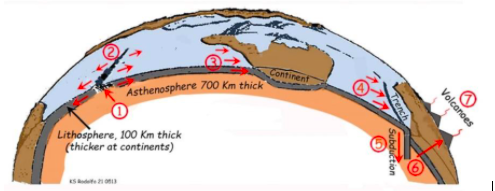
- At a “spreading center” usually in the ocean, molten parts of the asthenosphere rises as lava through a crack in the lithosphere. The lava solidifies there, making a new lithosphere that stands high as an ocean ridge and oceanic volcanoes because it is still swollen with heat. The new rocks and minerals absorb hot volcanic fluids, mainly water.
- Long before it cools, this new lithosphere splits at the spreading center into halves that move away from each other, making room for a still newer lithosphere to form as the process continues.
- The second role of the asthenosphere: being somewhat weak and pliable, it allows the plates to slowly slide over it. Continents embedded in the drifting lithosphere move passively with it. As the lithosphere migrates away from the spreading center it cools and shrinks, so the sea floor progressively deepens.
- After migrating for millions of years, the lithosphere, now hundreds of kilometers away from the ridge, has cooled enough to become denser than the underlying asthenosphere. The Earth is not getting any bigger, and so room for the new lithosphere is made by destroying older lithosphere elsewhere, usually far from where it was formed.
- Where such an old, dense plate collides with another plate, it is forced to “subduct” – sink back down into the Earth’s interior. Remember: the rates of all these motions are only a few inches or centimeters per year! So: Mother Earth, like a living being, is slowly but constantly rejuvenating her thick rocky skin, growing it in some places, destroying it elsewhere.
- Earth’s temperature increases 25°C for every kilometer of depth. Returning into the planet’s hot interior, the lithosphere heats up. The fluids that the rock absorbed while still young and near the ridge begin to cook out of it. When and where a slab has sunk deeper than about a hundred kilometers, some of these escaping fluids rise into the overlying asthenosphere, helping to make new molten rock called “magma.” Small amounts of it, enriched in water and other gases, percolate up through the rocks behind the trench, and accumulate in pool 10 kilometers or so below the surface.
- From time to time, some of the pressurized magma punches through the overlying plate, making volcanoes like Pinatubo, Natib and Mariveles.
The crazy tectonics of the Philippines
So far, the process seems fairly straightforward. But the Philippines is where three major tectonic plates, the Pacific, Eurasian, and Australian plates, all meet, collide, jostle, and slide past each other. All that activity makes our region the world’s most chaotic assemblage of small volcanic–island arcs, trenches, spreading centers, and small basins. No wonder we suffer such frequent seismic and volcanic disasters.
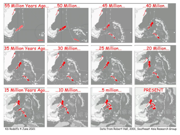
Our geologic history from as far back as we can see reflects that slow-motion chaos:
This is why Filipinos really should know some plate tectonics, to understand some of the most important forces that affect us, and to recognize the insanity of activating the BNPP or building a nuclear power plant anywhere in our archipelago.
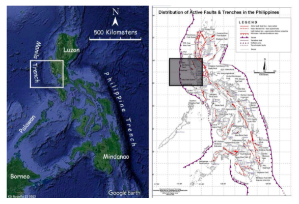
The left frame is an image of our terrain, both the land and under the ocean. The right frame at the same scale is the map of tectonic features compiled by the Philippine Institute of Volcanology and Seismology (Phivolcs). It’s not here for you to study closely, just to give you a sense of how amazingly complex Philippine geology is.
The Manila Trench west of Luzon is about 1,100 kilometers long. Its extent from the south of Taiwan to where it ends off northern Mindoro were nicely defined in 2001 in a geophysical analysis of northern Luzon by a Phivolcs team led by Bart and Leo Bautista. They used the distribution and behaviors of our many regional earthquakes, combined with the textures and shapes of the seafloor west of Luzon. A prime example of how excellent Philippine science can be, their report stands the test of time very well. It is relied on heavily by nervous tsunami specialists in China, Taiwan, Vietnam, Singapore, and Thailand.
But for now, we will concentrate only on the area of western Bataan and Zambales, marked as rectangles on the maps.
Plate subduction beneath Zambales and Bataan
West of the Philippines is a small lithospheric plate that got its name from the overlying South China Sea, long before the Philippine government, reacting to China’s expansionism, started calling it the “West Philippine Sea.” It is basically passive while the Philippine lithosphere pushes northwestward against it about 9 to 5 centimeters a year. Being denser than the complex rock mass we call the “Philippine Mobile Belt,” the South China Sea Plate is forced to thrust under it into Earth’s hot interior.
Geological Philippine response to Chinese political aggression? Just kidding…
Where the South China Sea Plate starts to go down is marked by the Manila Trench, a long, deep furrow. The South China Sea is about one and a half kilometers deep; the greatest depth of the trench is almost five and a half kilometers.
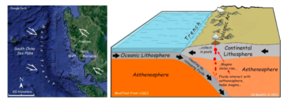
Where the top of the China Sea Plate has been shoved down into the increasingly-hot Earth about a hundred kilometers deep, it is heated enough to sweat out its fluids. These fluids interact with the asthenosphere under the Philippines, making rising blobs of magma that accumulate in pools some 10 kilometers beneath the surface, as the cartoon shows.
From time to time, magma rises from a pool to cause a volcanic eruption. That is why Mts. Pinatubo, Natib, and Mariveles line up parallel to the Manila Trench.
The subduction started sometime 22 to 25 million years ago. It continues, as the Philippine lithosphere inexorably drives against the South China Sea Plate.
Now, using your God-given common sense, tell me: do you think Pinatubo, Natib, Mariveles, or some new volcano will ever erupt again, or not?
The Manila Trench subduction poses another terrific hazard to the BNPP: “megathrust” earthquakes, the most powerful kind, and the tsunamis they generate. We look at them in our next foray. – Rappler.com
Keep posted on Rappler for the next installment of Rodolfo’s series.
Born in Manila and educated at UP Diliman and the University of Southern California, Dr. Kelvin Rodolfo taught geology and environmental science at the University of Illinois at Chicago since 1966. He specialized in Philippine natural hazards since the 1980s.
Previous pieces from Tilting at the Monster of Morong:
- [OPINION] Tilting at the Monster of Morong
- [OPINION] Mount Natib and her sisters
- [OPINION] Sear, kill, obliterate: On pyroclastic flows and surges
- [OPINION] Beneath the waters of Subic Bay an old pyroclastic-flow deposit, and many faults
- [OPINION] Propaganda about faulting, earthquakes, and the Bataan Nuclear Power Plant
- [OPINION] Discovering the Lubao Fault
- [OPINION] The Lubao Fault at BNPP, and the volcanic threats there
Add a comment
How does this make you feel?

![[OPINION] Who decides whether Bataan should go nuclear?](https://www.rappler.com/tachyon/2023/08/imho-bataan-nuclear-powerplant.jpg?resize=257%2C257&crop=271px%2C0px%2C720px%2C720px)
![[OPINION] Nuclear energy should not become major part of Philippine energy system](https://www.rappler.com/tachyon/2023/01/nuclear-energy-january-26-2023.jpg?resize=257%2C257&crop=205px%2C0px%2C900px%2C900px)

![[Time Trowel] There is more to archaeology than Indiana Jones’ pistol and whip](https://www.rappler.com/tachyon/2023/12/tl-timetrowel.jpg?resize=257%2C257&crop=245px%2C0px%2C720px%2C720px)

There are no comments yet. Add your comment to start the conversation.