SUMMARY
This is AI generated summarization, which may have errors. For context, always refer to the full article.
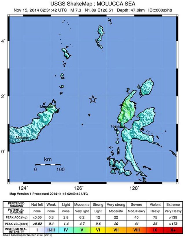
JAKARTA, Indonesia (3rd UPDATE) – A powerful 7.1-magnitude* earthquake rocked the Maluku Islands in eastern Indonesia Saturday, November 15, sparking a tsunami warning for areas up to 300 kilometers (185 miles) away and causing panicked people to flee their homes.
There were no immediate reports of casualties or damage after the undersea quake struck at a depth of 46 kilometers (28 miles) northwest of Kota Ternate, a town in the Malukus, at 0231 GMT, the US Geological Survey said.
“Tsunami waves are possible for coasts located within 300 kilometers,” said the Pacific Tsunami Warning Center.
The center said tsunami waves could hit parts of Indonesia, as well the Philippines, Japan, Taiwan and islands in the South Pacific.
On the tiny Sangihe Islands close to the epicenter in Indonesia, people ran out of their homes when the quake hit, Toni Supit, head of the islands’ Sitaro district, told Agence France-Presse (AFP).
“People in coastal areas felt the strong quake, which lasted for quite some time, and they immediately went to the sea to see if the water was receding abnormally, which is a sign of an incoming tsunami,” he said.
Life was returning to normal after the initial shock and people were returning to their homes, he said, but added that local authorities were encouraging people to stay away from beaches until the tsunami warning was lifted.
Tsunami waves between 30 centimeters (12 inches) and one meter could hit parts of Indonesia, said the Pacific Tsunami Warning Center.
“We have issued an early tsunami warning,” an official from Indonesia’s meteorological agency told AFP.
People in the northern Maluku Islands and in the north of central Sulawesi island were in particular being asked to stay away from the coast, added Mochammad Riyadi, head of the earthquake and tsunami department at Indonesia’s weather agency.
Indonesia sits on the Pacific “Ring of Fire” where continental plates collide, causing frequent seismic and volcanic activity.
A huge undersea quake in 2004 triggered a tsunami that killed more than 170,000 people in Aceh province, on western Sumatra island, and tens of thousands more in other countries with coasts on the Indian Ocean.
A 6.1-magnitude quake that hit inland in Aceh in July last year left at least 30 people dead and thousands homeless.
It caused a mosque to collapse in one village, killing 6 children as they took part in a Koran reading session. – Rappler.com
*Editor’s Note: The US Geological Survey initially reported a 7.3-magnitude earthquake.
Add a comment
How does this make you feel?
There are no comments yet. Add your comment to start the conversation.