SUMMARY
This is AI generated summarization, which may have errors. For context, always refer to the full article.

MANILA, Philippines (UPDATED) – Office of the Civil Defense Undersecretary Alexander Pama advised tourists and motorists on Friday, October 16, to postpone travels to Northern Luzon over the weekend as Typhoon Lando (international codename: Typhoon Koppu) approached the country.
“Kung hindi naman importante ang biyahe sa norte ay ipagpaliban na lang muna po,” Pama said. (If the travel is not important, then your are advised to postpone it.)
Typhoon Lando is expected to make landfall between 4 am to 8 am Sunday, October 18. The Japan Meteorological Agency classified Lando as a typhoon with a strong intensity.
Given the radius of the storm, at 250 kilometers, Pama said that rains should be expected as early as Saturday noon, October 17, in the northern and central parts of Luzon.
“Ang hinihingi lang po namin ay paghandaan ang bagyo at sumunod sa mga lokal na awtoridad,” Pama said. (What we’re asking for is [for everybody] to prepare for the typhoon and to follow local authorities.)
@reyaika @rapplerdotcom @ProjectAgos advisable pa ba tumuloy kme sa baguio tom morning?
— caroline velmonte (@dvampsis23) October 16, 2015
‘Red Alert’
In the Cordilleras, the management of Mount Pulag National Park released an advisory for climb organizers and hikers to stay off the mountain from October 16 to 18.
The Mount Pulag Protected Areas Management, led by Superintendent Emerita Albas, issued the advisory on Friday after warnings from the Cordillera Regional Disaster Risk Reduction and Management Council (CRDRRMC) about the tropical cyclone.
CRDRRMC Chairman and Office of Civil Defense Regional Director Andrew Alex Uy said a red alert status was now in effect as storm warning signal Noumber 1 was raised over the provinces of Kalinga, Ifugao and Mountain Province on Friday morning.
According to Pama in Manila, Typhoon Lando is anticipated to get stronger with more rains.
As of 4 pm Friday, the eye of Lando was located at 510 km East of Baler, Aurora, with a maximum sustained winds of 130 km/h near the center, and gustiness up to 160 km/h. (READ: NDRRMC national headquarters on red alert over Typhoon Lando)
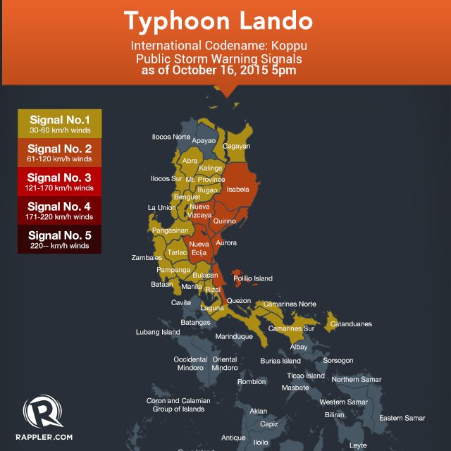 Currently, Public Storm Warning Number 2 (61-120 km/h expected in 24 hours) is raised over Aurora, Isabela, Quirino, Nueva Vizcaya, Nueva Ecija, and Northen Quezon, including Polilio Island.
Meanwhile, Signal Number 1 has been raised over more areas (30-60 km/h expected in 36 hours):
- CAR: Abra, Kalinga, Mt. Province, Ifugao, Benguet
- Region 1: Ilocos Sur, La Union, Pangasinan
- Region 2: Cagayan
- Region 3: Bulacan, Pampanga, Tarlac, Zambales
- Region 4A:Bataan, Rizal, Laguna, rest of Quezon
- Region 5: Camarines Norte, Camarines Sur, Catanduanes
- Metro Manila
The state weather bureau will issue another bulletin on Typhoon Lando on Saturday, 11 am. – with a report from Jessa Mardy Polonio/Rappler.com
Add a comment
How does this make you feel?
There are no comments yet. Add your comment to start the conversation.