SUMMARY
This is AI generated summarization, which may have errors. For context, always refer to the full article.
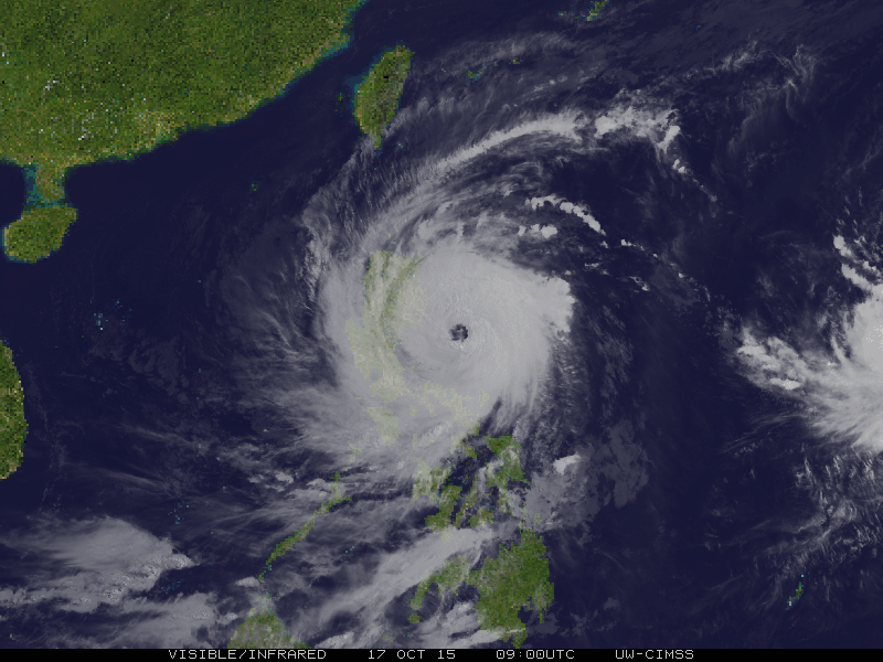
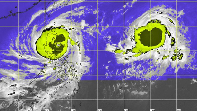
MANILA, Philippines – The United States Navy’s Joint Typhoon Warning Center (JTWC) upgraded Typhoon Lando (Koppu) to super typhoon status on Saturday at 11 pm, October 17.
Independent local weather organization Weather Philippines followed suit an hour after, 12 am, Sunday, October 18, calling Lando “a dangerous Super Typhoon” as it continues to move slowly westward in the past 6 hours approaching the shoreline of Aurora.
“This cyclone will bring powerful winds and heavy rains across the eastern sections of Northern Luzon today through Sunday,” Weather Philippines said in its advisory.
In its 11 pm bulletin, however, state weather bureau PAGASA maintained that Lando was still a typhoon. It spotted the storm at 135 km east northeast of Baler, Aurora or 90 km east southeast of Casiguran, Aurora (16.0°N, 122.9°E).
Lando further intensified as it threatens Aurora, Isabela, and Northern Quezon, according to PAGASA. It continued to pack maximum sustained winds of 185 km/h near the center and gustiness of up to 220 km/h.
PAGASA raised storm warning signals in 36 areas. The list can be found below along with PAGASA’s explanation of the effects of the wind under different storm signals.
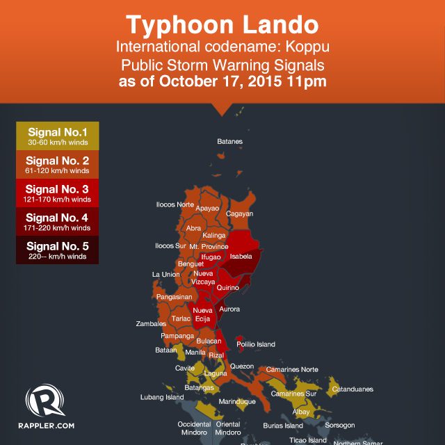
Public Storm Warning Signal No. 4 (171-220 km/h, expected in 12 hours)
Aurora, Southern Isabela
Impacts of the wind:
• Very heavy damage to high-risk structures
• Heavy damage to medium-risk structures;
• Moderate damage to low-risk structures
• Considerable damage to structures of light materials (up to 75% are totally and partially destroyed); complete roof structure failures.
• Many houses of medium-built materials are unroofed, some with collapsed walls; extensive damage to doors and windows
• A few houses of first-class materials are partially damaged
• All signs/billboards are blown down. There is almost total damage to banana plantation,
• Most mango trees, ipil-ipil and similar types of large trees are downed or broken.
• Coconut plantation may suffer extensive damage.
• Rice and corn plantation may suffer severe losses.
Public Storm Warning Signal No. 3 (121-170 km/h, expected in 18 hours)
Rest of Isabela, Quirino, Nueva Vizcaya, Nueva Ecija, Ifugao, and Northern Quezon including Polillo Islands
Impacts of the wind:
• Heavy damage to high-risk structures;
• Moderate damage to medium-risk structures;
• Light damage to low-risk structures
• Increasing damage (up to more than 50%) to old, dilapidated residential structures and houses of light materials. Majority of all nipa and cogon houses may be unroofed or destroyed
• Houses of medium strength materials (old, timber or mixed timber-CHB structures, usually with G.I. roofings); some warehouses or bodega-type structures are unroofed.
• There may be widespread disruption of electrical power and communication services.
• Almost all banana plants are downed
• Some big trees (acacia, mango, etc.) are broken or uprooted
• Dwarf-type or hybrid coconut trees are tilted or downed.
• Rice and corn crops may suffer heavy losses
• Damage to shrubbery & trees with foliage blown off; some large trees blown down.
Public Storm Warning Signal No. 2 (61-120 km/h, expected in 24 hours)
Cagayan including Calayan and Babuyan group of Islands, Benguet, Mt. Province, Abra, Kalinga, Apayao, Ilocos Norte, Ilocos Sur, La Union, Pangasinan, Zambales, Tarlac, Pampanga, Bulacan, Rizal, rest of Quezon, Camarines Norte and Metro Manila
Impacts of the wind:
• Light to Moderate damage to high-risk structures;
• Very light to light damage to medium-risk structures;
• No damage to very light damage to low-risk structures
• Unshielded, old dilapidated schoolhouses, makeshift shanties, and other structures of light materials are partially damaged or unroofed.
• A number of nipa and cogon houses may be partially or totally unroofed.
• Some old galvanized iron (G.I.) roofs may be peeled or blown off.
• Some wooden, old electric posts are tilted or downed.
• Some damage to poorly constructed signs/billboards
• In general, the winds may bring light to moderate damage to the exposed communities. Most banana plants, a few mango trees, ipil-ipil and similar types of trees are downed or broken
• Some coconut trees may be tilted with few others broken
• Rice and corn may be adversely affected
• Considerable damage to shrubbery and trees with some heavy-foliaged trees blown down.
Public Storm Warning Signal No. 1 (30-60 km/h expected in 36 hours)
Batanes, Bataan, Cavite, Laguna, Batangas, Lubang Island, northern Oriental Mindoro, Marinduque, Camarines Sur, Albay and Catanduanes
Impacts of the wind:
• Very light or no damage to low-risk structures,
• Light damage to medium to high-risk structures
• Slight damage to some houses of very light materials or makeshift structures in exposed communities. Some banana plants are tilted, a few downed and leaves are generally damaged
• Twigs of small trees may be broken.
• Rice crops, however, may suffer significant damage when it is in its flowering stage.
PAGASA said Lando is expected to make landfall in the Aurora area early Sunday morning, October 18. – Rappler.com
Add a comment
How does this make you feel?
There are no comments yet. Add your comment to start the conversation.