SUMMARY
This is AI generated summarization, which may have errors. For context, always refer to the full article.
MANILA, Philippines – Just like Nepal, which was struck by major earthquakes in the last 3 weeks, the Philippines is also due for a powerful one.
The “Big One,” which experts say may happen in our lifetime, could strike once the West Valley Fault moves.
The West Valley Fault, which traverses various parts of Metro Manila and surrounding provinces, is expected to greatly affect the country since the region is not only highly populated, it also hosts the seat of government and the country’s business capital.
Before the Philippine Institute of Volcanology and and Seismology (Phivolcs) released its latest and more detailed maps of the Valley Fault System, quite a number of studies had been conducted, simulating the impact of an earthquake in Metro Manila. (READ: Fault-finders, storm-chasers: Hazard mapping in the PH)

How prepared is Metro Manila for a strong quake?
The MMEIRS study is prepared to have plans and strategies in place should a strong quake rock Metro Manila. It’s time to review it.
In 2004, Phivolcs and the Metropolitan Manila Development Authority (MMDA), together with Japan International Cooperation Agency (JICA), conducted a study called the Metro Manila Earthquake Impact Reduction Study (MMEIRS). It analyzed different earthquake scenarios in Metro Manila.
In 2010, further studies were conducted as scientific agencies, called the Collective Strengthening on Community Awareness on Natural Disasters (CSCAND), started the Greater Metro Manila Risk Assessment Project Risk Analysis Project (GMMA-RAP). It allowed agencies to create maps that determine the depth of hazards present in an area, the extent and the frequency of hazards, and also the worst case scenario through modeling.
The 3-year project, funded by the AusAID through the UNDP, focuses on Metro Manila, but also includes portions of Bulacan, Rizal, Cavite, and Laguna.
Various information campaigns have been done to disseminate findings from these studies and educate people on how to prepare for this potentially devastating earthquake.
But are Filipinos really ready for it?
Here’s what you need to know about the West Valley Fault earthquake scenarios and what you need to know to survive the “Big One.”
The West Valley Fault has a 400-year cycle
The West Valley Fault, a 100-kilometer fault, is one of the segments of an active fault, the Valley Fault System.
The West Valley Fault transects portions of:
- Quezon City
- Marikina
- Makati
- Pasig
- Taguig
- Muntinlupa
- Bulacan (Doña Remedios Trinidad, Norzgaray, San Jose Del Monte City)
- Rizal (Rodriguez)
- Laguna (San Pedro City, Biñan, Sta Rosa, Cabuyao, Calamba)
- Cavite (Carmona, General Mariano Alvarez, Silang)
Phivolcs recently released new, high resolution maps of this fault system that show details down to street level. You can check if your community is one of those near the fault line through the Atlas here: Download the West Valley Fault Atlas
The fault, which has moved 4 times in the last 1,400 years, moves roughly every 400 years, according to Phivolcs Director Renato Solidum.
The last major earthquake generated by this fault was in 1658, or 357 years ago. This means the metro is already due for the next big quake.
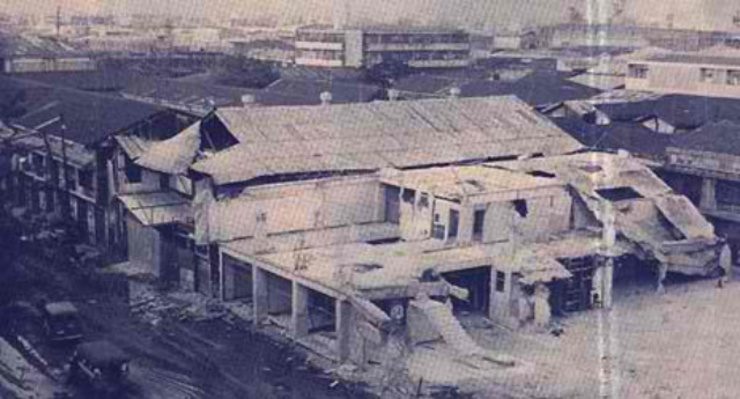
It is not the only fault line that could affect the metropolis. The last big earthquake that caused damage in Metro Manila was the one that destroyed the Ruby Tower in the 1960s. That earthquake was caused by a fault line in Casiguran, Aurora, north of Metro Manila.
(The 1990 Luzon Earthquake, which severely damaged the cities of Baguio, Cabanatuan, and Dagupan, was also felt in Metro Manila, but did not do damage to the Philippine capital.)
In the studies conducted, however, what emerged as the worst case scenario is a magnitude 7.2 earthquake from the West Valley Fault on a weekday and at night. Why night time? Partly because the studies found that the buildings most at risk of damage in the metropolis are residential buildings, according to Solidum. (READ: INFOGRAPHIC: How powerful is a magnitude 7.2 earthquake)

Sign that the West Valley Fault moved
Given that it is not the only fault line that could affect Metro Manila, how do you know if it is the West Valley Fault that moved?
You will know by detecting the type of motion you feel when the earthquake strikes.
According to Solidum, those near the epicenter of a quake will first feel an up and down ground motion, followed by a horizontal ground motion.

Those farther from the epicenter will only feel a horizontal ground motion.

If the West Valley Fault moves, the whole of Metro Manila will be affected in varying degrees. These areas may feel that up and down motion.
| Caloocan | Paranaque |
| Las Pinas | Pasay |
| Malabon | Pasig |
| Makati | Pateros |
| Mandaluyong | Quezon City |
| Manila | San Juan |
| Marikina | Taguig |
| Muntinlupa | Valenzuela |
| Navotas |
Those living in provinces near the metro – such as Bulacan, Rizal, Cavite, and Laguna – may also feel the up and down motion.
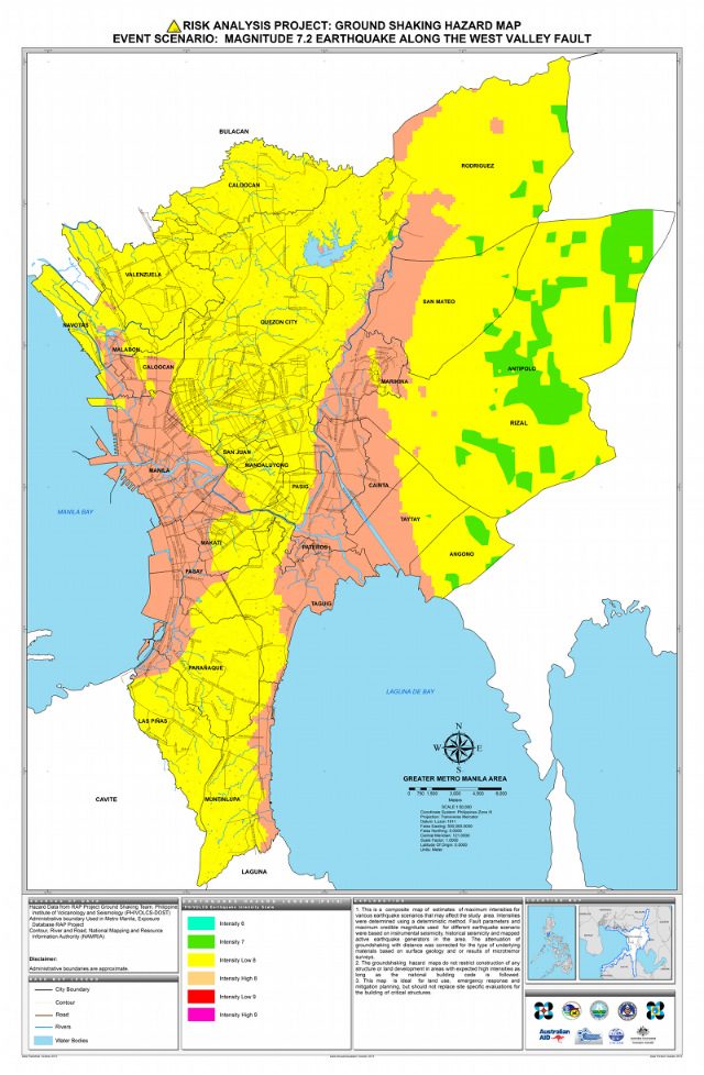
The areas that will feel the strongest ground shaking (Intensity High 8 in the map), however, will not just be those near the fault itself, namely Marikina, Cainta, half of Taytay, Pateros, and Taguig.
The cities of Manila, Makati, Malabon, Pasay, and Caloocan, though relatively far from the actual fault line, will feel the same intensity levels as those near the fault line.
According to Solidum, this is because the foundation of those areas, especially Manila, are thick sediments that “amplify ground shaking.”
The Manila Cathedral, located within the Intramuros area in the city of Manila, has been destroyed by earthquakes multiple times because of this.
Effects of an earthquake on the West Valley Fault
Just like the Nepal earthquake, the effects of a magnitude 7.2 earthquake on a highly populated area like Metro Manila will include strong ground shaking, damaged infrastructure and utilities, and a potentially huge casualty count.
-
Damaged buildings, homes, other infrastructure
At the time the MMEIRs study was conducted, there were 1,325,896 residential buildings, 981 mid-rise buildings, 119 high-rise buildings, and 1,826 public-purpose buildings.
Public-purpose buildings at the time included hospitals (177), schools (1,412), fire stations (124), police stations (43), city and municipal halls (53).
Of these, the study projected, residential buildings would sustain bulk of the damage from the earthquake. Details of damage projections below:
-
Residential buildings – 339, 800 (25.6%) partly damaged; 168,300 (12.7%) heavily damaged
-
Mid-rise buildings (10-30 stories) – 27% partly damaged, 11% heavily damaged
-
High-rise buildings (30-60 stories) – 2% heavily damaged, 12% partly damaged
-
Public-purpose buildings – 8-10% heavily damaged, 20-25% partly damaged
The quality of construction and the type of building materials used play a big role in a building’s chances of surviving the earthquake, according to experts at Phivolcs.
Unfortunately, many houses and buildings do not follow standards. (READ:12-point checklist for an earthquake-resistant house)
Simulations conducted as part of the GMMA-RAP study show potential damages per area given various scenarios. Potential damages from a magnitude 7.2 earthquake on the West Valley Fault are shown in the map below.
As a general rule, older, poorly designed buildings and those built of inferior materials are more vulnerable to collapse, according to Solidum.
-
Damaged power lines, fire breakouts
At the time the MMEIRs study was conducted, some 4,482 kilometers of electrical/power lines connected the different parts of the city to the main electrical power sources. The MMEIRs study says 30 kilometers of this massive transmission and distribution system could be damaged if a magnitude 7.2 earthquake strikes.
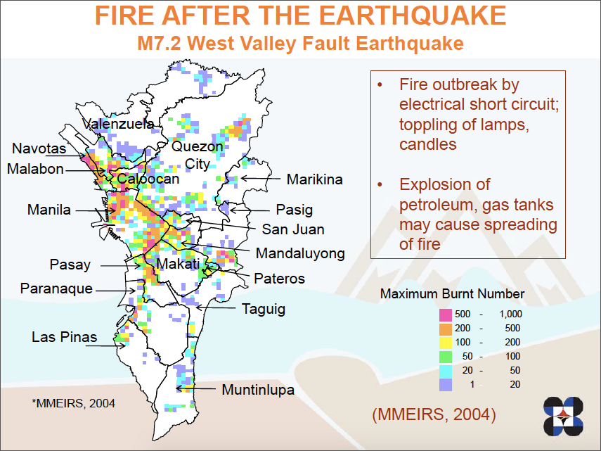
Particularly vulnerable to fire are the urban poor areas where illegal and substandard electrical connections are common. Damaged electrical lines could trigger fire to break out in various parts of the city which could result in more casualties, according to the study.
It can be difficult for authorities to address these breakouts as public-purpose buildings, including fire stations, are among those expected to be damaged by the earthquake.
Mobility within the city will also be severely affected as some roads, bridges and flyovers are expected to sustain damages during the quake.
-
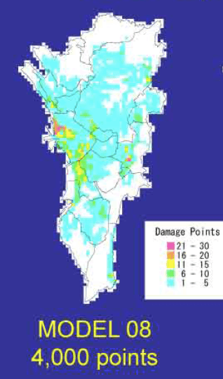
Water supply, communication lines
At the time of the MMEIRS study, the total length of water distribution pipes in Metro Manila was estimated at 4,615 kilometers. This system will be broken at 4,000 different points, according to the study.
Angat Dam, where 97% of Metro Manila gets its water supply, is also near the faultline and may also be affected by a strong ground shaking, resulting to a potential water leakage.
Like in Nepal, communication lines within the city will also be greatly affected.
Based on the MMEIRS, Metro Manila’s communication backbone consists of over 9,445 kilometers of aerial cables and almost 4,000 kilometers of underground cables. In the earthquake’s aftermath, 95 kilometers of this will be damaged making communication impossible.
-
Human impact
The impact of an earthquake emanating from a fault line that cuts across Metro Manila is definitely more devastating than that which happened in Nepal on April 25.
The Nepal quake, whose epicenter was located 80 kilometers away from the Nepalese capital Kathmandu, resulted in over 8,000 casualties. Compared to Manila, Kathmandu is less dense, with only roughly a million residents.
Metro Manila, during daytime, has a population of roughly 14 million, with a night time population of about 11 million.
The GMMA-RAP simulation map below shows potential casualties per square kilometer in case a 7.2 magnitude earthquake strikes at 7 pm, when most people are already at home. You can use the search bar to check potential casualties in your community or barangay.
Bulk of the casualties are expected to result from building collapse. The rest will be from fire and related hazards.
Based on the MMEIRS, a magnitude 7.2 earthquake from the West Valley Fault in this mega city will leave 33,500 people dead.
An additional 18,000 could perish as fire breaks out in various parts of the city mostly due to damaged electrical wirings. On top of these, some 113, 600 more will be injured.
Apart from expected casualties, such an earthquake, according to the MMEIRS study, could leave 3.15 million people homeless.
As in Kathmandu, experts say hospitals may also be either incapacitated due to power and water supply failure as well as damages from the earthquake or overwhelmed by the number of patients pouring in.
What needs to be done
The new, more detailed maps should help people become more aware of the danger zones in their communities.

#TalkThursday: Metro Manila earthquake scenarios
Rappler talks to Phivolcs Director Renato Solidum about what could happen if a 7.2-magnitude earthquake hits Metro Manila
More than knowing where the hazards are and the impact of a potential earthquake on their neighborhood, however, people need to know what can be done to reduce potential casualties and prepare for the “Big One.”
Solidum stressed the importance of following the Building Code, making sure the code is updated and knowing what to do and where to go when an earthquake strikes.
“Shaking does not kill, collapsing buildings do,” he said in an earlier interview with Rappler. (WATCH: #TalkThursday: Metro Manila earthquake scenarios)
Solidum also advises families to prepare by knowing the safest areas in their houses and to conduct regular earthquake drills at home, in schools, and offices. – with Gwen de la Cruz, Gemma Bagayaua Mendoza, and Wayne Manuel/Rappler.com
Learn more about how you, your family, and your community can do to prepare:
A list of things to do to prepare when an earthquake strikes
A checklist to identify if your house is earthquake-resistant
A list of things your family can do to prepare for an earthquake
A 40-minute conversation with Phivolcs Director Renato Solidum and safety and disaster risk reduction advocate Martin Aguda on how the public should prepare for the “Big One”
Phivolcs director Renato Solidum talks about the different earthquake scenarios that can happen in Metro Manila
The Philippine Institute for Volcanology and Seismology (Phivolcs) is a Project Agos partner. The project is supported by the Australian Government.
Add a comment
How does this make you feel?
There are no comments yet. Add your comment to start the conversation.