SUMMARY
This is AI generated summarization, which may have errors. For context, always refer to the full article.
What’s the weather like in your area? Tweet us the situation: Use #weatheralert and tag @rapplerdotcom.

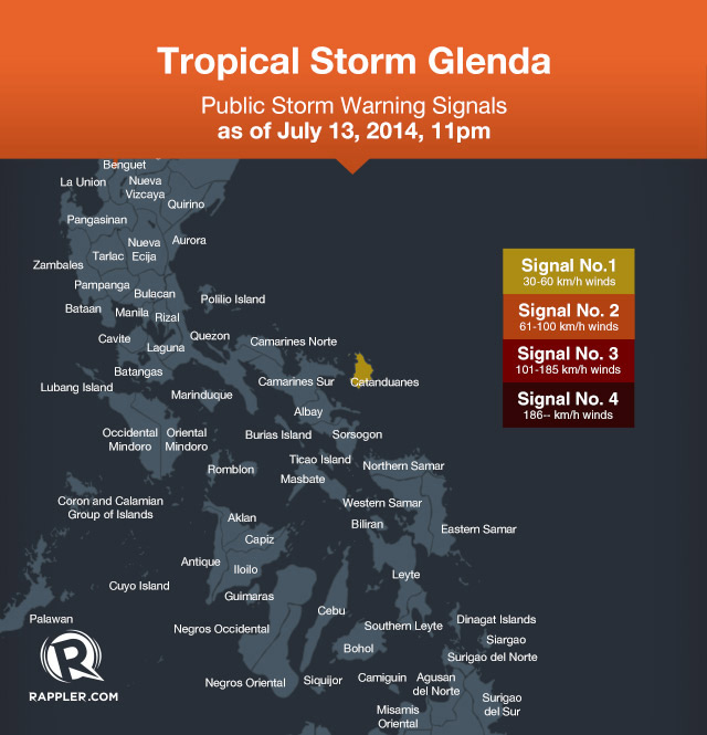
MANILA, Philippines – Public Storm Signal No 1 was declared over Catanduanes in Bicol region on the night of July 13 as Tropical Storm Glenda (international name Rammasun) approaches the Philippines.
This means the province of Catanduanes should expect 30 to 60 kilometers per hour (kph) winds within the next 36 hours.
Philippine state weather bureau PAGASA, in its July 13, 11 pm update, said the storm was spotted 940 kilometers east of Virac, Catanduanes at 10 pm.
Glenda registered maximum sustained winds of 65 kph near the center with gustiness of up to 80 kph.
It is expected to move west at a speed of 30 kph. Areas within the 400-kilometer diamater of the storm may experience moderate to heavy (7.5 to 15 millimeters an hour) of rainfall.
PAGASA warned that the storm will make sea travel risky in the Eastern coasts of Luzon and Visayas.
It alerted the public, local government officials and the National Disaster Risk Reduction and Management Council (NDRMMC) to take necessary action to prepare for the weather system’s effects.
The next update will be issued at 5 am on Monday, July 14.
Landfall by Wednesday
Glenda is expected to make landfall in Quezon province on Wednesday, July 16.
Until then, it is likely to bring heavy rainfall over Bicol and northern Samar. If it maintains its track, it could be over Metro Manila on Wednesday.
Independent weather monitoring agency Weather Philippines said moderate to heavy rains (30 to 55 mm) will likely fall in certain areas in Bicol from Tuesday morning to Wednesday morning. These areas are: Catanduances; Camarines Norte; the towns of Caramoan, Garchitorena and Siruma in Camarines Sur.
Flood and landslides are expected in Region III and some areas of Region I and Region II. – Rappler.com
Learn how to prepare for the coming storm on Rappler’s Project Agos microsite.
Add a comment
How does this make you feel?
There are no comments yet. Add your comment to start the conversation.