SUMMARY
This is AI generated summarization, which may have errors. For context, always refer to the full article.
What’s the weather like in your area? Tweet us the situation: Use #weatheralert and tag @rapplerdotcom
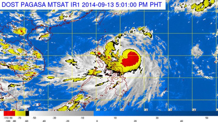
MANILA, Philippines (UPDATED) – State weather bureau PAGASA has raised storm Signal No. 2 over Cagayan and Isabela, as Tropical Storm Luis (Kalmaegi) intensified further on Saturday afternoon, September 13.
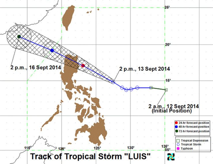
As of 4 pm on Saturday, the eye of the storm was located at 364 kilometers northeast of Virac, Catanduanes. It is seen to move west northwest at 20 km per hour.
Luis packs maximum sustained winds of 110 km per hour near the center, and gustiness of up to 140 km per hour. Heavy to intense rainfall (7.5 to 20 mm per hour) is expected within the storm’s 400-km diameter.
Signal No. 1 was also raised over the following areas:
- Calayan and Babuyan Group of Islands
- Apayao
- Kalinga
- Mountain Province
- Ifugao
- Nueva Vizcaya
- Quirino
- Aurora
- Catanduanes

Residents in low-lying and mountainous areas in areas under Signal Nos. 1 and 2 should watch out for possible landslides and flashfloods.
In addition, residents in coastal areas under signal number 2 are alerted against storm surges.
Fishing boats and other small seacrafts are advised not to set sail into the seaboards of Visayas and the eastern seaboard of southern Luzon and Mindanao.
Luis is expected to be at 138 km northeast of Casiguran, Aurora, by Sunday afternoon, September 14; at 238 km west northwest of Laoag City by Monday afternoon, September 15; and, at 481 km west northwest of Laoag City by Tuesday afternoon, September 16.
The next bulletin on Tropical Storm Luis will be issued at 11 pm on Saturday.
Sunday weather
Isabela and Cagayan will experience stormy weather with rough to very rough seas. Meanwhile, all areas under signal no. 1 will have rains with gusty winds.
It will be cloudy with moderate to occasionally heavy rains and thunderstorms – which may trigger flashfloods and landslides – in the Bicol Region and the provinces of Samar and Quezon.
The rest of Luzon and Visayas will be cloudy with light to moderate rainshowers and thunderstorms. Meanwhile, Mindanao will have partly cloudy to cloudy skies with isolated rainshowers or thunderstorms.
Here is the weather forecast across the country for Sunday, September 14:
| City | Forecast | Temperature Range |
|
| Metro Manila |  |
Cloudy skies with rainshowers and/or thunderstorms |
24°C-31°C |
| Tuguegarao |  |
Stormy | 24°C-29°C |
| Laoag | |
Cloudy skies with rainshowers and/or thunderstorms |
25°C-30°C |
| Baguio | |
Stormy | 16°C-24°C |
| Subic/Olongapo; Clark/Angeles | |
Cloudy skies with rainshowers and/or thunderstorms |
24°C-30°C |
| Tagaytay | |
Cloudy skies |
21°C-29°C |
| Lipa | |
Cloudy skies with rainshowers and/or thunderstorms |
23°C-32°C |
| Legazpi | |
Cloudy skies with rainshowers and/or thunderstorms |
24°C-31°C |
| Puerto Princesa | |
Cloudy skies |
24°C-30°C |
| Iloilo/Bacolod | |
Cloudy skies |
24°C-30°C |
| Metro Cebu | |
Cloudy skies with rainshowers and/or thunderstorms |
24°C-29°C |
| Tacloban | |
Cloudy skies with rainshowers and/or thunderstorms |
24°C-29°C |
| Cagayan de Oro |  |
Partly cloudy to cloudy skies with isolated rainshowers or thunderstorms |
22°C-32°C |
| Metro Davao | |
Partly cloudy to cloudy skies with isolated rainshowers or thunderstorms |
24°C-32°C |
| Zamboanga | |
Partly cloudy to cloudy skies with isolated rainshowers or thunderstorms |
25°C-32°C |
– Rappler.com
Add a comment
How does this make you feel?
There are no comments yet. Add your comment to start the conversation.